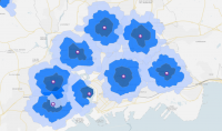
Noise Pollution Mapping

Noise pollution mapping is a way to show how loud different places are. It uses data to make maps that highlight noisy areas. These maps help us understand where noise is a big problem.
What Does a Noise Pollution Map Show?

A noise pollution map shows where sounds are loudest in an area. It uses colors to represent different noise levels. For example, red might mean very loud, while blue is quiet.
These maps often include sounds from roads, trains, and airports. By looking at a sound pollution map, you can see which parts of a city are noisiest. Just like this National Transportation Noise Map.
This helps city planners make better decisions. They can create quiet zones or improve building designs. So, noise pollution maps are very useful for reducing noise in our environments.
Who Uses a Noise Pollution Map?
We use noise pollution maps for a variety of different reasons. But here are the main users for sound pollution maps:

- City planners: They use noise maps to design urban spaces that minimize noise pollution. For example, they might prefer building residential areas away from noisy highways.
- Community activists: Armed with data from noise maps, activists push for changes to reduce noise pollution. They can lobby for the construction of sound barriers or stricter regulations on noise.
- Real estate agents: Agents use noise maps to provide potential buyers with the noise environment of properties. This can influence purchasing decisions in favor of quieter locations.
- Government officials: Officials use noise maps to enforce noise regulations. This can develop new policies for noise control, and plan public works projects that consider the impact of noise.
- Residents: People living in noisy areas use noise maps to learn more about their noise environment. Noise maps can help them make better personal decisions about where to live.
Sound Pollution Maps
Noise pollution mapping helps us understand and tackle noise in our surroundings. By visualizing noise in decibels (dBA), urban planners can make cities quieter and healthier for people.
Have you ever used a noise pollution map? How did you use it? Please let us know in the comment section below.


