Raster Clip in GIS
Learn how to clip rasters in ArGIS using the raster clip tool in ArcToolbox as well as the clip button as part of the Raster Functions.
Learn how to clip rasters in ArGIS using the raster clip tool in ArcToolbox as well as the clip button as part of the Raster Functions.
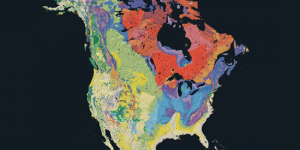
Geology maps depict where the underlying rock formations are. It displays rocks of different ages showing eras, periods and epochs.

The image analysis toolbar can generate NDVI maps in ArcGIS. NDVI shows areas of high and low vegetation and requires red and NIR bands.
This list of earth-shattering remote sensing applications will change the way you feel about how this industry is changing our world and the way we think.
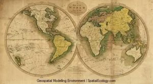
Hawth’s Tool’s successor is Geospatial Modelling Environment. GME provides an assortment of movement, conversion, geometry and statistical tools.
Create thousands of maps instantly with data driven pages in ArcGIS. Learn more about adding dynamic text, zooming to extents and exporting PDF mapbooks

Turbo-charge your search for free GIS data with this list of 10 free, downloadable global GIS datasets from highly reputable sources – vector and raster.

This guide shows how Mean Absolute Error in GIS is used. We give a step-by-step instructions how to calculate MAE in Excel and a quick formula to use.

Configure your time series animation in ArcGIS with this tutorial. Visualize geographic events (snow melt, forest fire, disease) in time
Natural Earth data is a free raster and vector (cultural and physical) data package containing the most common elements that you need to create a map.