Fort Worth Texas Map

Map of Fort Worth
This Fort Worth map shows highways/roads, reference information, and things to do. If you want to interactively view the city, you can explore the Google Maps of Fort Worth, Texas.
Our map of Fort Worth Texas is an easy-to-use and informative tool that will help you plan your trip. Plus, it’s just a short distance to Dallas, Texas, just 30 miles (50 km) east via I-30 E.
Discover the best things to do and see in the Fort Worth area in Texas. This map includes tourist information, such as how to get to the city’s most popular attractions, museums, and shopping areas.
Jump To: Interactive Map | Printable Road Map | 10 Things to Do | Reference Map
Fort Worth map collection

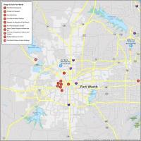
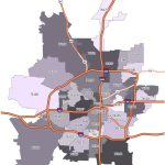
Interactive Map of Fort Worth
This map includes all the attractions, hotels, restaurants, and more that you will need to plan your trip. Whether you’re planning a day out or you’re on vacation, this map will help you find your way around.
This map is like having an interactive tour of the city which includes museums, sports venues, and lots of shopping. You have everything you need to know so you can get around and have a great time.
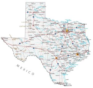
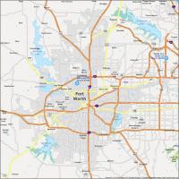
Fort Worth Road Map
If you’re in town for a visit, you’ll love how much you can do in such a small space. With that in mind, we’re here to help you get your bearings with a road map. Explore everything Fort Worth has to offer with this detailed map.
Know where to go and where to avoid with our detailed map of the city, which includes interstate highways, major roads, and transportation options. But if you’re traveling outside the city, download our Texas road map for free.
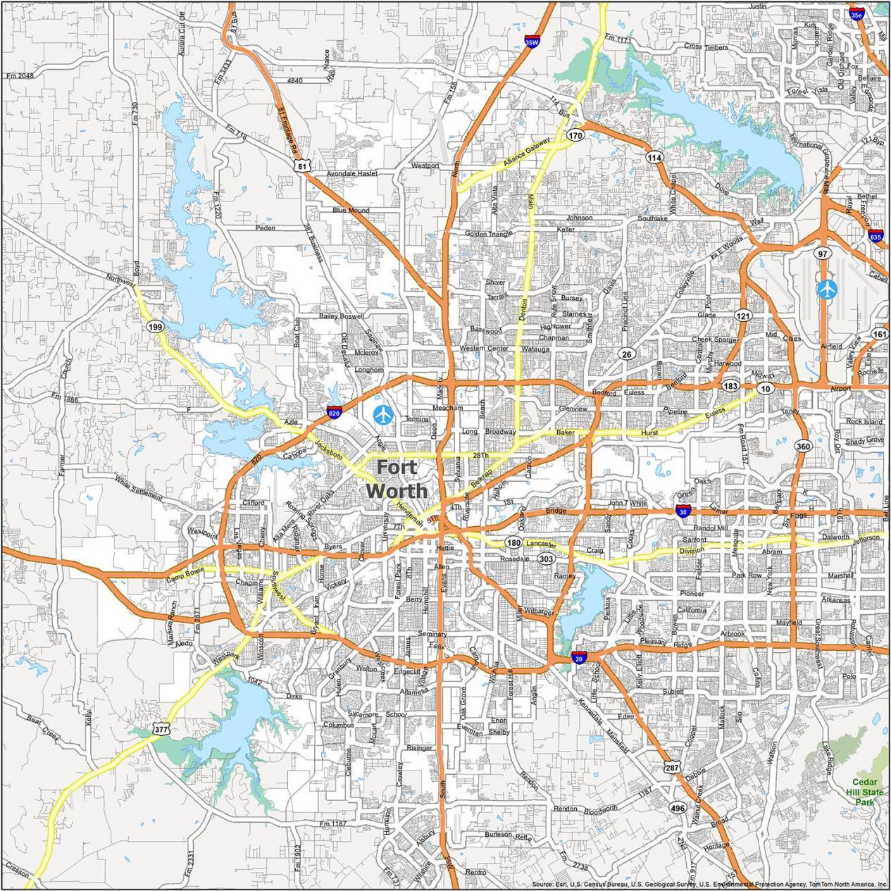
Interstate Highways: I-20, I-30, I-35W, I-820
US Highways: 80, 81, 97, 114, 121, 170, 180, 183, 199, 287, 303, 347 Spur, 360, 377, Benbrook Hwy, Jacksboro Hwy, Mansfield Hwy
Freeways/Parkways: Alliance Gateway Fwy, North Fwy, Martin Luther King Fwy, Pioneer Pky, South Fwy
Major Roads: 4th St, 5th St, 6th St, 7th St, 28th St, Alta Mere Dr, Beach St, Belknap St, Bellaire Dr, Berry St, Bluff St, Camp Bowie Blvd, Commerce St, Ephriham Ave, Forest Park Blvd, Henderson St, Houston St, Hulen St, Lake Worth Blvd, Lancaster Ave, Main St, River Oaks Blvd, Riverside Dr, Rosedale St, Saginaw Blvd, Southwest Blvd, University Dr, Weatherford St
10 Things To Do in Fort Worth
Explore what the city has to offer and discover its hidden gems. It’s no secret that Fort Worth is a hotbed of art and culture, though it can be difficult to find a way to experience all the offerings.
Whether you’re a fan of local music, art, history, or dining, the city’s offerings are vast and constantly changing. This Fort Worth map highlights some of the most popular and interesting places to visit in the city.

Fort Worth is an old-west style city, so it’s nicknamed “Cowtown”. If you ever travel to Forth Worth, we recommend these top 10 things to do.
- Fort Worth Stockyards
- Kimbell Art Museum
- Fort Worth Zoo
- Fort Worth Water Gardens
- Modern Art Museum of Fort Worth
- Fort Worth Botanic Garden
- Amon Carter Museum of American Art
- Fort Worth Museum of Science and History
- Ripley’s Believe It or Not!
- Fort Worth Nature Center & Refuge
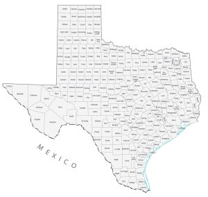
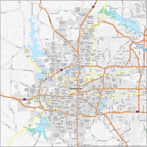
Fort Worth Reference Map
This guide will help you learn more about Fort Worth’s neighborhoods. Make the most of your next trip to Fort Worth by exploring the city with this reference map. Whether you’re in the city or just visiting, the map is the perfect companion to help you plan your vacation. Learn about its lakes, parks, and populated areas with this map.
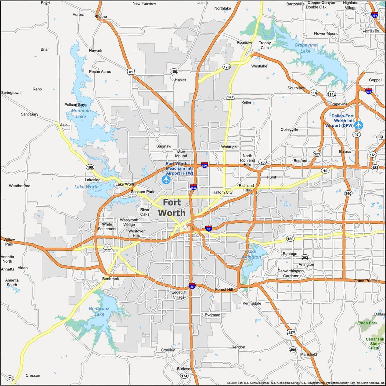
Airports: Dallas/Fort Worth International Airport (DFW)
Cities: Aledo, Arlington, Aurora, Azle, Bedford, Benbrook, Blue Mound, Burleson, Cedar Hill, Colleyville, Coppell, Cresson, Crowley, Dallas, Dalworthington Gardens, Euless, Everman, Forest Hill, Fort Worth, Grand Prairie, Grapevine, Haltom City, Haslet, Highland Village, Hurst, Irving, Justin, Keller, Kennedale, Lake Worth, Lewisville, Mansfield, Midlothian, New Fairview, Newark, North Richland Hills, Pelican Bay, Reno, Rhome, Richland Hills, River Oaks, Roanoke, Saginaw, Sansom Park, Southlake, Springtown, Watauga, Weatherford, Westworth Village, White Settlement, Willow Park
Towns: Annetta, Annetta North, Annetta South, Bartonville, Boyd, Copper Canyon, Double Oak, Edgecliff Village, Flower Mound, Lakeside, Northlake, Pantego, Sanctuary, Trophy Club, Westlake, Westover Hills
Census-designated place (CDP) Briar, Lantana, Pecan Acres, Rendon