Louisville Zip Code Map
Louisville Zip Code Table
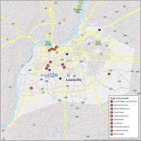
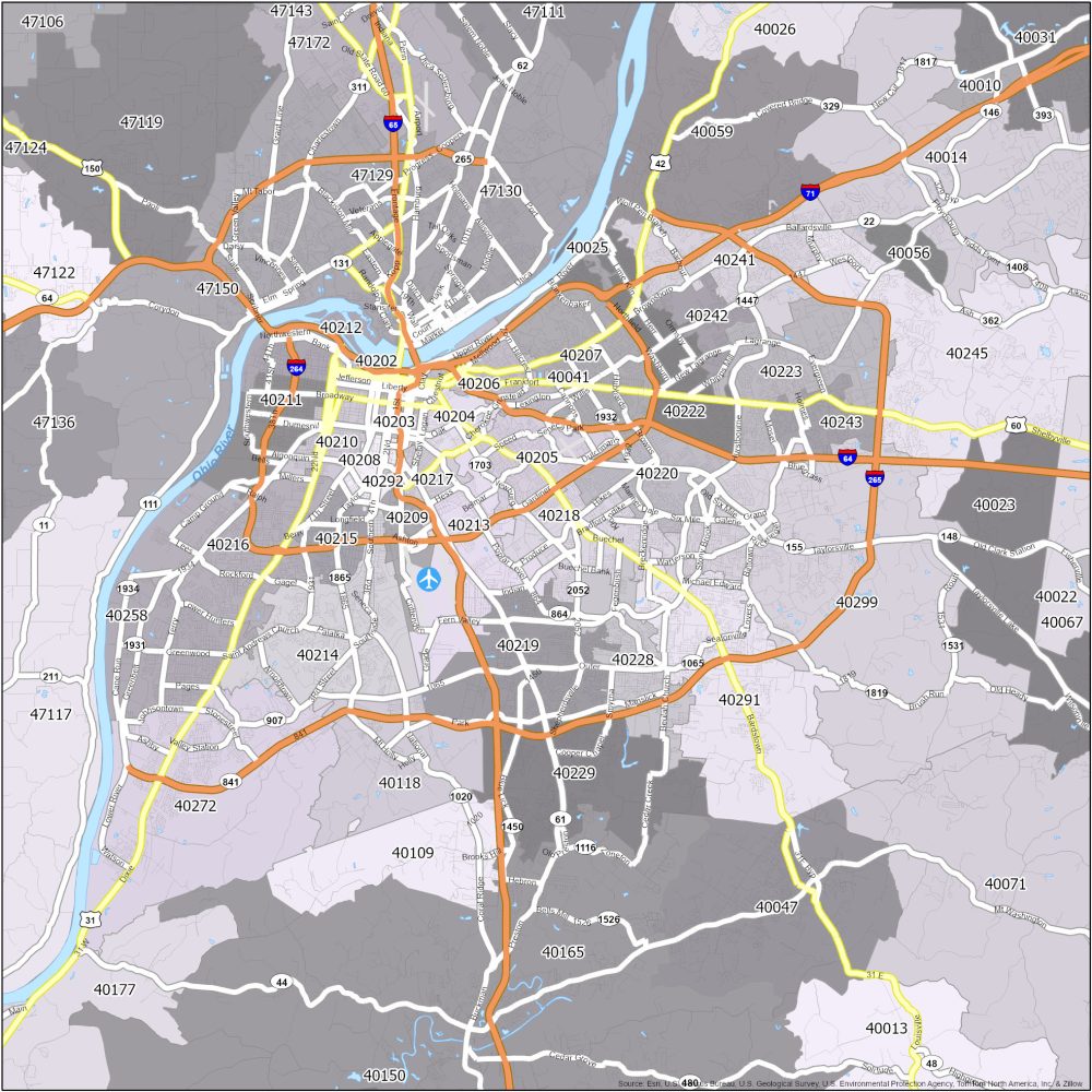
Presented above is a color-coded zip code map of Louisville. This is how to see postal regions and interstate highways in the city. This Louisville zip code map is for anyone who wants to send letters by mail.
| Zip Code | Name | State | Population | Square Miles |
|---|---|---|---|---|
| 40202 | Louisville | KY | 8,181 | 2.37 |
| 40203 | Louisville | KY | 19,196 | 2.73 |
| 40204 | Louisville | KY | 15,075 | 3.03 |
| 40205 | Louisville | KY | 23,127 | 6.86 |
| 40206 | Louisville | KY | 20,749 | 6.89 |
| 40207 | Louisville | KY | 29,854 | 12.56 |
| 40208 | Louisville | KY | 14,116 | 2.35 |
| 40209 | Louisville | KY | 1,245 | 2.84 |
| 40210 | Louisville | KY | 14,623 | 3.59 |
| 40211 | Louisville | KY | 21,694 | 7.65 |
| 40212 | Louisville | KY | 16,950 | 6.91 |
| 40213 | Louisville | KY | 17,273 | 12.29 |
| 40214 | Louisville | KY | 45,694 | 15.81 |
| 40215 | Louisville | KY | 22,540 | 3.66 |
| 40216 | Louisville | KY | 41,878 | 16.39 |
| 40217 | Louisville | KY | 12,618 | 2.38 |
| 40218 | Louisville | KY | 31,650 | 8.48 |
| 40219 | Louisville | KY | 38,593 | 14.14 |
| 40220 | Louisville | KY | 34,557 | 7.71 |
| 40222 | Louisville | KY | 23,209 | 11.72 |
| 40223 | Louisville | KY | 23,406 | 12.82 |
| 40228 | Louisville | KY | 16,921 | 8.68 |
| 40229 | Louisville | KY | 38,695 | 18.07 |
| 40241 | Louisville | KY | 30,514 | 12.05 |
| 40242 | Louisville | KY | 10,521 | 3.38 |
| 40243 | Louisville | KY | 11,070 | 4.09 |
| 40245 | Louisville | KY | 34,842 | 34.91 |
| 40258 | Louisville | KY | 26,776 | 13.09 |
| 40272 | Louisville | KY | 37,412 | 36.18 |
| 40291 | Louisville | KY | 38,460 | 25.04 |
| 40292 | Louisville | KY | 0 | 0.09 |
| 40299 | Louisville | KY | 43,109 | 53.05 |