Understanding Map Scale in Cartography
Understanding the importance of map scale
Map scale is an essential cartographic tool for understanding the map we interact with. Because when it comes to maps, not all are created equal.
Different maps offer different levels of detail depending on the scale of the map. Understanding map scales and the differences between them is key to making sure you have the right map for your needs.
This article will provide an introduction to exploring the 3 types of map scales. By the end of this article, you’ll have a better understanding of different map scales. You’ll also learn about the important role they play in understanding the world around us.
What is a map scale?
A map scale is a way of measuring the distance or area depicted on a map using numbers. Understanding the scale of a map is important because it allows you to properly interpret its content. For instance, USGS topographic maps are all defined with a specific map scale.
You can think of map scales as a type of measurement tool in the same way as you would think of a ruler or a tape measure. For example, if a map of a town has a scale of 1:30,000, it means that 1 centimeter on the map represents 30,000 centimeters in real life. In other words, 3 centimeters on the map would be about 300 meters in real life.
If a map has a larger scale, it means that it has more detail, but it will also have less scope. Alternatively, a smaller-scale map will have less detail, but it will also be more expansive. For example, a 1:10,000,000 map will show you an entire country. Whereas a scale of 1:100 can represent someone’s backyard.
Types of map scales
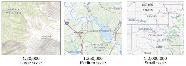
In general, we classify maps as either small-scale, medium-scale, or large-scale. There are no rules to classify a map into a type of map scale. But here are some general guidelines you can follow.
Large-scale maps
A large-scale map is a map that shows a smaller geographic area in greater detail than a small-scale map. These maps can be useful for tracking traffic, planning development, etc.
Large-scale maps are for smaller areas such as towns, parks, or campuses. It often includes features such as street names, building outlines, and land use information. This means that it shows more information about the area being mapped.
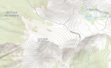
Although there are no set limits for large-scale maps, such maps are usually produced on a scale of 1:250,000 or larger. It often includes topographical details, roads, and other man-made features.
Medium-scale maps
These maps are used to represent an area at a larger scale than a large-scale map, yet smaller than a small-scale map. Medium-scale maps are often used for regional planning, resource management, and general overviews.
These maps are usually detailed enough to provide the physical features of an area, such as roads, rivers, and other terrain elements. But they don’t have finer details like bike paths, parking lots, or trails.
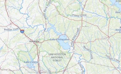
There is no standard for a medium-scale map, but they typically range from 1:250,000 to 1:1,000,000. Medium-scale maps are typically used to represent geographic regions larger than a city or town. But they’re usually smaller than an entire nation or country, such as a state or province.
Small-scale maps
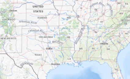
A small-scale map is a type of map that represents a larger geographic area with less detail and accuracy. Such maps typically show generalized features rather than specific details. Common small-scale maps include world maps, topographic maps, and political maps.
Small-scale maps are generally used to depict the entire region or continent. There are no defined limits but this type of map may have a scale of 1:1,000,000 or smaller. As such, this means that each unit of measurement on the map is much larger than on a large-scale map.
Small-scale maps tend to have less detailed information than their large-scale counterparts. But they can still provide valuable information. They are specifically useful for providing reference locations given a larger geographic extent.
Examples of types of maps
Here are some examples of various types of maps and whether or not to consider them small-scale, medium-scale, or large-scale maps. Remember that there are no standards and that these are basic guidelines.
| Map Type | Scale Limits | Representation |
| Small-scale map | 1:1,000,000 or smaller | World maps, continents, large countries, or oceans |
| Medium-scale map | 1:250,000 to 1:1,000,000 | Countries, states, provinces, or large mountain ranges |
| Large-scale map | 1:250,000 or larger | Cities, counties, municipalities, towns, parks, or campuses |
How to use map scale in cartography
Understanding map scale is important for you as a map user and for anyone who wants to make sense of maps.
It’s an important cartographic element that can greatly improve your understanding of the level of detail in a map. Maps differ greatly in terms of scale, from 1:100,000,000 (a map of the whole world) to as small as a backyard.
As you explore different maps, you can see that no two maps are alike. Different scales present different features. Each one has its own advantages and disadvantages.
Now that you know about different types of maps, you can begin to appreciate the concept of map scales.


Thank you for a great article
You’re right RC, mistake in calculation.
Alright! Truth to power. Kinda.
Mistake in “calculation”
Clip from text above:
“1:30,000, it means that 1 centimeter on the map represents 30,000 centimeters in real life (3 centimeters on the map would be about 300 meters in real life).”
1 cm –> 300 m or 3 cm –> 900 m