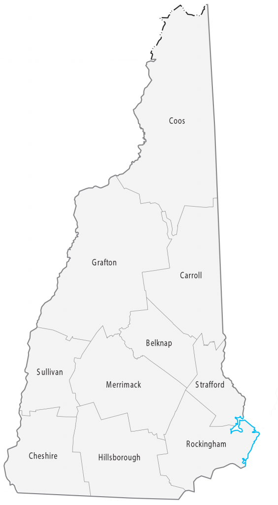
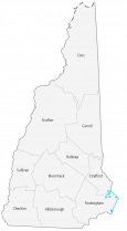
New Hampshire County Map
About the map
This New Hampshire county map displays its 10 counties. New Hampshire’s tally of only 10 counties ranks fifth fewest in all of the United States. Only Connecticut, Hawaii, Rhode Island, and Delaware have fewer counties than New Hampshire.
Hillsborough County is the most populous county in New Hampshire because it’s home to Manchester. But the state capital, Concord, is in Merrimack County. The least populated county in New Hampshire is Coos County with just over 31,000 people.
For size, Coos County in the north of New Hampshire is the largest county and occupies an area of over 1830 square miles. But the smallest county is Strafford County, which is only 380.8 square miles in area.
You are free to use our county map of New Hampshire for educational and commercial uses. Attribution is required. How to attribute?
New Hampshire county list
| FIPS Code | Name | Land (sq mi) | Water (sq mi) | Population (2024) |
|---|---|---|---|---|
| 33-001 | Belknap County | 401.8 | 68.2 | 65,257 |
| 33-003 | Carroll County | 931.9 | 61.6 | 52,580 |
| 33-005 | Cheshire County | 706.7 | 22.2 | 78,078 |
| 33-007 | Coos County | 1794.6 | 35.7 | 31,094 |
| 33-009 | Grafton County | 1708.6 | 41.1 | 93,045 |
| 33-011 | Hillsborough County | 876.5 | 15.9 | 430,462 |
| 33-013 | Merrimack County | 932.9 | 22.1 | 157,869 |
| 33-015 | Rockingham County | 695.4 | 99.9 | 322,433 |
| 33-017 | Strafford County | 367.6 | 15.0 | 134,202 |
| 33-019 | Sullivan County | 537.5 | 14.6 | 44,012 |