What Is Oblique Imagery?

DEFINITION:
Oblique imagery is a type of aerial or satellite image that is taken at an angle, rather than straight down at nadir.
What is the difference between vertical and oblique imagery?
Simply put, oblique imagery is all about angles. While traditional images are taken from directly above, oblique images capture them at an angle.
So, instead of viewing the roof of a building, oblique images show the sides of buildings too. This gives us a new perspective that top-down images cannot capture.
What angles are oblique images? They’re usually taken downward between 40° to 50° angles. But they can also be high oblique imagery, which includes the horizon.

What are the benefits of oblique imagery?
Think of oblique images as the middle ground between a map and a ground-level photo. Its main advantage is its ability to capture new information that would otherwise be missed.
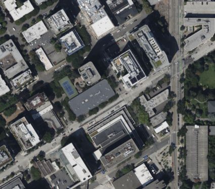
What types of information can you see in the oblique imagery that you can’t see in the nadir imagery?
Oblique Imagery:
- Shows sides of objects (e.g., buildings, mountains).
- Helps gauge height and depth.
- Offers a more realistic view, like seeing it in person.
- Good for understanding a building’s design or a mountain’s steepness.
Nadir Imagery:
- Top-down view, directly overhead.
- Great for maps and layout views.
- Shows patterns and arrangements clearly (e.g., roads, fields).
- Lacks perspective on height or depth.
The table above compares when you should consider using oblique and nadir imagery.
How can you use oblique imagery?
Here are some of the major use cases for oblique imagery:
Urban planning: Helps city planners see buildings and streets from different angles. Planners use it to see how new buildings will fit into existing cityscapes.

Real estate: Shows potential buyers what a property looks like from the side, not just the top. This makes it possible to see the architectural details of houses.
Emergency response: Gives rescuers a clearer idea of what they’re dealing with, like after a natural disaster. You can see house colors and other features to identify addresses.
Environmental studies: Scientists use it to study landscape changes, like erosion. With oblique imagery, they can see the sides of hills or valleys, which you can’t see in nadir imagery.
Construction Monitoring: Tracks progress on construction projects. Oblique imagery provides a comprehensive view of the site and possibilities to measure height.
Each of these factors contributes to the growing usage of oblique imagery.
Oblique imagery equipment and software
Capturing oblique imagery isn’t as simple as tilting a camera. It requires specialized equipment and software to put it in geographic space.
Here are some of the main software packages that can handle this type of imagery:
Bing Maps

Bird’s Eye Imagery is a nice new feature in Bing Maps. What does it do? You can view cityscapes and neighborhoods from a slant perspective.
Keep in mind that it doesn’t have oblique imagery everywhere in the world. Just check out some of the major cities and you’ll likely find it there.
Eagleview Pictometry

ConnectExplorer is a web-based application. Everything is stored in the cloud. So, that means all you have to do is connect from a web browser.
This is how to access your local imagery. Eagleview Pictometry allows you to zoom, pan, and change perspectives. You can also measure distance, area, and height with the measurements and annotations tools.
ArcGIS Pro Image Space Analyst
Image Space Analysis allows you to view oblique imagery in ArcGIS Pro. It does this by using an image coordinate system (ICS) from your image metadata.
When you use Image Space Analyst, you can change your image to perspective mode. Once you do this, mensuration tools provide vertical tools for height and volume.
Low oblique vs high oblique
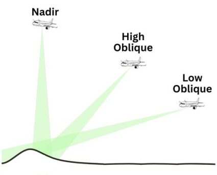
The difference between low oblique and high oblique imagery lies in the angle of the camera relative to the horizon.
Low oblique imagery uses a camera angled enough to avoid including the horizon in the frame. This means that it’s focusing at an angle more closely on the subject.
On the other hand, a high oblique imagery includes the horizon in the photograph. Low oblique images are less common in GIS, as images are typically between angles of 40° to 50°.
Is there such a thing as oblique videos?
As technology advances, so too does the utility of oblique imagery. One such way is through oblique videos with full motion video (FMV).

How is full motion video different from regular video? It dynamically captures the geographic footprint. This means that it’s able to link what’s shown in the video with what’s on the ground.
Innovations in drone technology are making oblique imagery easier. It opens up new possibilities, as GIS continues to integrate this technology.
Oblique imagery: Let’s wrap this up
Oblique imagery gives us a special look at our landscape. It shows the sides and heights of things, which we can’t see from straight above.
This is helpful for people working in building, selling houses, or helping in emergencies.
That’s about all we have to say about oblique imagery. Do you have any questions or comments? Please let us know in the comment section below.


