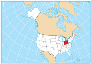
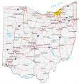
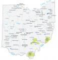
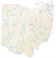
Ohio County Map

About the map
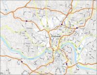
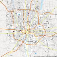
This Ohio county map displays its 88 counties. Ohio’s 88 counties rank as the 13th highest out of all states. The state capital, Columbus is located in Franklin, Ohio. This is the most populated county with over 1.3 million residents.
In fact, both Franklin County and Cuyahoga County are in the top 50 for the highest population in the United States. The least populated county in Ohio is Vinton County with just over 13,000 residents.
For size, counties in Ohio are quite uniform in area. They really don’t have any stand-outs for size and range anywhere between 200 to 750 square miles. While Lake County is the smallest county in Ohio, Ashtabula County is the largest.
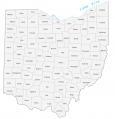

You are free to use our county map of Ohio for educational and commercial uses. Attribution is required. How to attribute?
Ohio County List
| FIPS Code | Name | Land (sq mi) | Water (sq mi) | Population (2024) |
|---|---|---|---|---|
| 39-001 | Adams County | 583.9 | 2.4 | 27,671 |
| 39-003 | Allen County | 402.5 | 4.3 | 100,866 |
| 39-005 | Ashland County | 423.0 | 3.8 | 52,420 |
| 39-007 | Ashtabula County | 702.1 | 665.8 | 96,906 |
| 39-009 | Athens County | 503.6 | 4.8 | 63,218 |
| 39-011 | Auglaize County | 401.4 | 0.5 | 45,922 |
| 39-013 | Belmont County | 532.1 | 9.1 | 64,692 |
| 39-015 | Brown County | 490.0 | 3.4 | 44,292 |
| 39-017 | Butler County | 466.6 | 3.4 | 399,542 |
| 39-019 | Carroll County | 394.6 | 4.3 | 26,460 |
| 39-021 | Champaign County | 429.0 | 0.8 | 38,907 |
| 39-023 | Clark County | 396.9 | 5.7 | 134,985 |
| 39-025 | Clermont County | 452.1 | 7.7 | 214,123 |
| 39-027 | Clinton County | 408.7 | 3.6 | 42,019 |
| 39-029 | Columbiana County | 531.9 | 2.8 | 99,823 |
| 39-031 | Coshocton County | 563.9 | 3.5 | 37,003 |
| 39-033 | Crawford County | 401.8 | 0.9 | 41,626 |
| 39-035 | Cuyahoga County | 457.2 | 788.3 | 1,240,594 |
| 39-037 | Darke County | 598.1 | 1.6 | 51,462 |
| 39-039 | Defiance County | 411.4 | 2.7 | 38,644 |
| 39-041 | Delaware County | 443.2 | 14.2 | 237,966 |
| 39-043 | Erie County | 251.4 | 374.4 | 73,841 |
| 39-045 | Fairfield County | 504.4 | 4.2 | 167,762 |
| 39-047 | Fayette County | 406.4 | 0.7 | 28,782 |
| 39-049 | Franklin County | 532.4 | 11.2 | 1,356,303 |
| 39-051 | Fulton County | 405.4 | 1.8 | 42,028 |
| 39-053 | Gallia County | 466.5 | 4.7 | 28,886 |
| 39-055 | Geauga County | 400.3 | 8.0 | 95,362 |
| 39-057 | Greene County | 413.6 | 2.6 | 172,347 |
| 39-059 | Guernsey County | 522.3 | 6.0 | 38,219 |
| 39-061 | Hamilton County | 405.9 | 6.7 | 837,359 |
| 39-063 | Hancock County | 531.3 | 2.3 | 75,016 |
| 39-065 | Hardin County | 470.4 | 0.2 | 30,402 |
| 39-067 | Harrison County | 402.3 | 8.4 | 14,042 |
| 39-069 | Henry County | 416.0 | 3.7 | 27,536 |
| 39-071 | Highland County | 553.1 | 4.7 | 43,785 |
| 39-073 | Hocking County | 421.3 | 2.3 | 27,429 |
| 39-075 | Holmes County | 422.6 | 1.4 | 44,668 |
| 39-077 | Huron County | 491.5 | 3.3 | 58,168 |
| 39-079 | Jackson County | 420.3 | 1.2 | 32,723 |
| 39-081 | Jefferson County | 408.1 | 2.8 | 63,900 |
| 39-083 | Knox County | 525.5 | 4.1 | 63,848 |
| 39-085 | Lake County | 229.3 | 749.9 | 232,360 |
| 39-087 | Lawrence County | 453.4 | 3.9 | 55,829 |
| 39-089 | Licking County | 682.4 | 4.9 | 184,898 |
| 39-091 | Logan County | 458.4 | 8.3 | 46,085 |
| 39-093 | Lorain County | 491.2 | 432.2 | 322,030 |
| 39-095 | Lucas County | 340.7 | 255.1 | 426,291 |
| 39-097 | Madison County | 465.8 | 0.8 | 45,531 |
| 39-099 | Mahoning County | 411.5 | 13.7 | 225,786 |
| 39-101 | Marion County | 403.8 | 0.4 | 64,976 |
| 39-103 | Medina County | 421.4 | 1.6 | 184,625 |
| 39-105 | Meigs County | 430.1 | 2.9 | 21,491 |
| 39-107 | Mercer County | 462.4 | 11.0 | 42,648 |
| 39-109 | Miami County | 406.5 | 3.1 | 111,950 |
| 39-111 | Monroe County | 455.7 | 1.7 | 13,051 |
| 39-113 | Montgomery County | 461.5 | 2.9 | 537,443 |
| 39-115 | Morgan County | 416.4 | 5.4 | 13,532 |
| 39-117 | Morrow County | 406.1 | 1.1 | 35,927 |
| 39-119 | Muskingum County | 664.5 | 8.0 | 86,582 |
| 39-121 | Noble County | 398.0 | 6.6 | 14,269 |
| 39-123 | Ottawa County | 254.7 | 330.3 | 39,692 |
| 39-125 | Paulding County | 416.4 | 2.4 | 18,755 |
| 39-127 | Perry County | 407.9 | 4.6 | 35,682 |
| 39-129 | Pickaway County | 501.2 | 5.3 | 62,158 |
| 39-131 | Pike County | 440.3 | 3.7 | 27,065 |
| 39-133 | Portage County | 487.4 | 16.7 | 163,839 |
| 39-135 | Preble County | 424.2 | 2.3 | 40,801 |
| 39-137 | Putnam County | 482.5 | 1.8 | 34,206 |
| 39-139 | Richland County | 495.2 | 4.9 | 124,853 |
| 39-141 | Ross County | 689.2 | 3.8 | 76,046 |
| 39-143 | Sandusky County | 408.5 | 9.3 | 58,866 |
| 39-145 | Scioto County | 610.2 | 5.9 | 71,798 |
| 39-147 | Seneca County | 551.0 | 1.8 | 54,730 |
| 39-149 | Shelby County | 407.7 | 3.0 | 47,952 |
| 39-151 | Stark County | 575.3 | 5.3 | 374,091 |
| 39-153 | Summit County | 412.8 | 7.3 | 538,370 |
| 39-155 | Trumbull County | 618.0 | 18.5 | 200,300 |
| 39-157 | Tuscarawas County | 567.4 | 4.0 | 92,048 |
| 39-159 | Union County | 431.7 | 5.1 | 71,721 |
| 39-161 | Van Wert County | 409.2 | 1.3 | 28,887 |
| 39-163 | Vinton County | 412.4 | 2.6 | 12,545 |
| 39-165 | Warren County | 401.2 | 6.1 | 256,059 |
| 39-167 | Washington County | 632.0 | 8.0 | 58,332 |
| 39-169 | Wayne County | 554.9 | 1.9 | 116,632 |
| 39-171 | Williams County | 420.7 | 2.4 | 36,554 |
| 39-173 | Wood County | 617.2 | 3.3 | 133,077 |
| 39-175 | Wyandot County | 406.9 | 0.7 | 21,394 |