How the Public Land Survey System (PLSS) Works
Imagine. Centuries ago, surveyors set foot on vast, uncharted lands. With chains and links in hand, they began the monumental task of sectionalizing the United States into a cadastral grid. This was the dawn of the Public Land Survey System (PLSS).
The PLSS divides land in the United States into townships, ranges, and sections. It was established by the Land Ordinance of 1785 as a standardized system for surveying and distributing public land.
This article describes how the Public Land Survey System (PLSS) works.
Principal Meridian and Baseline
Where is the point of origin of the PLSS grid? First, the PLSS uses a principal meridian and baseline for controlling survey lines of a large tract. While the baseline runs east-west, the principal meridian runs north-south. The image below illustrates the orientation of the principal meridian and baseline.
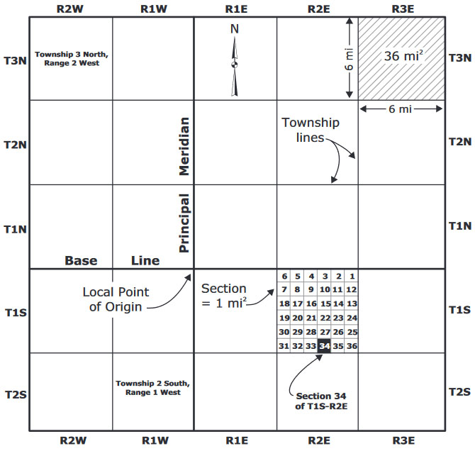
Where both the baseline and principal meridian intersect is the local point of origin. The PLSS establishes lines parallel (standard parallels) to the baseline at 24- or 30-mile intervals, which form a grid.
Townships and Ranges
After the initial survey, the PLSS splits land into townships. Because each side is 6 miles long, a township is a total of 36 square miles.
You can identify townships with two index values:
- Townships: The Township number tells you how far north or south it is from the baseline.
- Ranges: The Range number tells you how far east or west it is from the Principal Meridian.
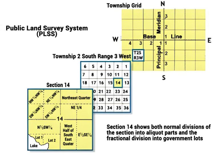
In the screenshot below, the township is T2S, R3W (Township 2 South, Range 3 West). This means it’s the second row of townships south of the baseline. It’s also the third row of ranges west of the Principal Meridian.
Sections
Sections are even smaller than townships. The PLSS divides each township into 36 sections. Each section covers one square mile (640 acres).
The PLSS numbers each 1-square-mile section sequentially starting with 1 in the northeast corner of a township. As shown below, it moves in east-west rows. Then, it wraps back and forth until it fills in the entire township.
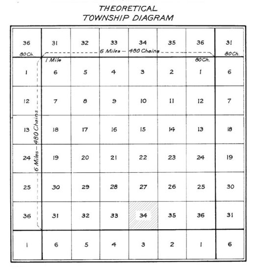
We’ve highlighted Section 34, T2S, R2E above. In long form, this is Section 34 (of) Township 2 South (of) Range 2 East.
Quarter Sections
Finally, the PLSS splits each section into four smaller quarter sections. Each quarter section measures 160 acres.
The example below shows section 34. As you can see, it’s split into 4 quarter sections (NW ¼, NE ¼ SW ¼, and SE ¼). For instance, the bottom-left quarter is SW ¼, Section 34, T1S, R2E.
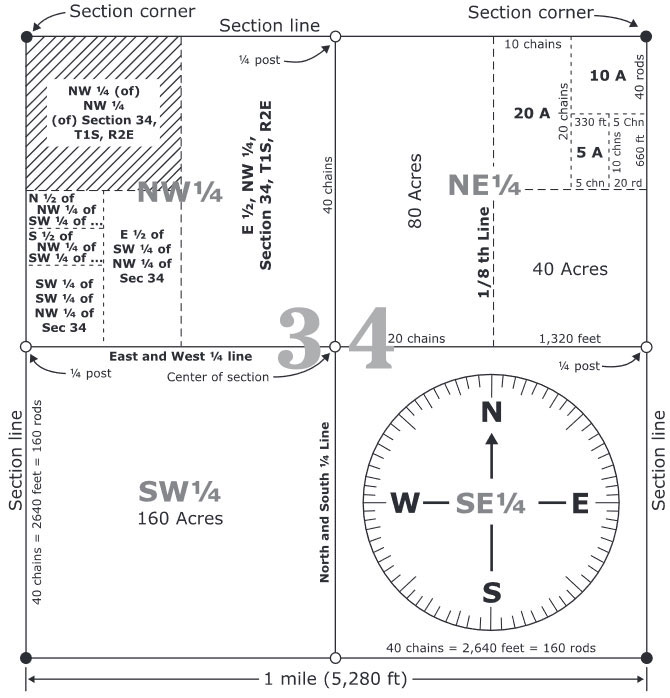
Not only can you describe units as ¼ sections, but you can split them as ½ sections. For example, we can identify the two left-side squares of a quarter section as W ½, Section 34, T1S, R2E.
Lots and Subdivisions
If you have a subdivision of land, surveyors can split ¼ sections into even smaller lots. You can describe a land parcel based on the smallest subdivision. Think about a neighborhood development with individual lots.
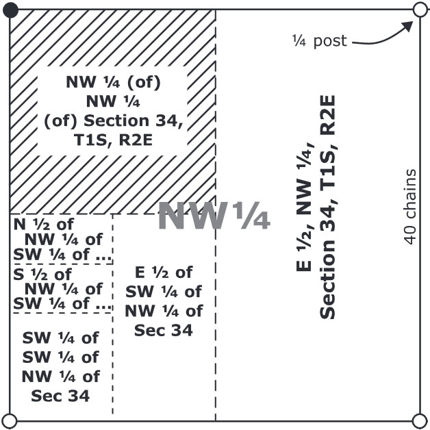
If you look at the hatched parcel in the screenshot below, we can describe it as NW ¼ (of) NW ¼ (of) Section 34, T1S, R2E. This means that it’s the northwest quarter of the northwest quarter of Section 34, Township 1 South, Range 2 East.
In a land titles system, you can identify each lot with its own unique ID. This helps keep records and the legal integrity of property ownership and boundaries.
How the Public Land Survey System (PLSS) Works
The Public Land Survey System (PLSS) maps out every inch of public land. This is the base of the cadastral system in the United States.
By establishing townships, ranges, sections, and quarter sections, the PLSS provides clarity in property boundaries.
Do you have any questions about the cadastral system? Please let us know your land title mapping questions with a comment below.


I don’t understand how surveyors dealt with hills and valleys, or streams and rivers. They laid out basically a flat surface. Chaining out a flat surface is one thing, but how can that work going up or down hill? the distance would not be the same.
The surveyors were instructed to measure “level” distances and made adjustments in the field to the chaining methods to account for slopes. I don’t have the exact details of how that was done, but the old manuals have been available online and could be checked as to the exact techniques. It would be very interesting, but I don’t have the time to look it up right now.
In a legal description how would you interpret a comma?
Example: That part of the Northwest Quarter (NW1/4), Northwest Quarter (NW1/4) of Section thirteen (13), Township Sixteen (16) North, Range Twenty (2), East
Do you consider the comma as a “and” or “including” part of the legal?
Is NeNeNw of section 36 1S7E a true 10 acres?
In theory, a quarter-quarter-quarter is 10 acres. In practice, however, it is unlikely to be a “true”, i.e., exactly 10 acres. If you’re inquiring about a particular land parcel (you didn’t provide the state or the PM, so it’s hard to know), your best bet is to look up the parcel in the county’s tax records. Many counties, but not all, have their land parcel maps available online.
Hello,
Are 40 corners assigned gps coordinates? How are 40 corners located by a surveyor?
Thank You,
Richard Whittington