What is Geodata? A Guide to Geospatial Data
DEFINITION:
Geodata (Geographic Data) is any data that has information about location on Earth, typically stored in vector, raster and attribute data.
What is Geodata?
Geodata is location information stored in a Geographic Information System (GIS). By viewing data with a geographic component, we see it through a different lens.
Geodata tackles the problem of location because geographic problems require spatial thinking. Let’s dive into the types, themes, and sources of geodata.
Types of Geographic Data
There are different types of geographic data and each of these has its own unique value in how you use them.
Whether the data is from government, private sources, or open data, it’s important to understand the type of data, where it comes from, how it is collected, and what it can be used for.
From vector to raster, or web-based to multi-temporal, here are some of the most common types of data along with their benefits and drawbacks.
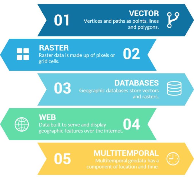
1. Vector Files
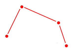
Vector data consists of vertices and paths. The three basic types of vector data are points, lines, and polygons (areas). Each point, line, and polygon has a spatial reference frame such as latitude and longitude.
First, vector points are simply XY coordinates. Secondly, vector lines connect each point or vertex with paths in a particular order. Finally, polygons join a set of vertices. But it encloses the first and last vertices creating a polygon area.
2. Raster Files
Raster data is made up of pixels or grid cells. Commonly, they are square and regularly spaced. But rasters can be rectangular as well. Rasters associate values with each pixel.
Continuous rasters have values that gradually change such as elevation or temperature. But discrete rasters set each pixel to a specific class. For example, we represent land cover classes to a set of values.
3. Geographic Database
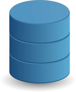
The purpose of geographic databases is to house vectors and rasters. Databases store geographic data as a structured set of data/information.
For example, Esri geodatabases, geopackages, and SpatiaLite is the most common type of geographic database. We use geographic databases because it’s a way to put all data in a single container.
Within this container, we can build networks, create mosaics, do versioning, and manage complex spatial relationships, enabling comprehensive analysis and representation of geographical data.
4. Web Files
As the internet becomes the largest library in the world, geodata has adapted with its own types of storage and access.
For example, GeoJSON, GeoRSS, and web mapping services (WMS) were built specifically to serve and display geographic features over the internet.
Additionally, online platforms such as Esri’s ArcGIS Online allow organizations to build data warehouses in the cloud.
5. Multi-temporal
Multi-temporal data attaches a time component to information. But multi-temporal geodata not only has a time component but a geographic component as well.
For example, weather and climate data track how temperature and meteorological information change in time in a geographical context. Other examples of multi-temporal geodata are demographic trends, land use patterns, and lightning strikes.
READ MORE: The Ultimate List of GIS Formats and Geospatial File Extensions
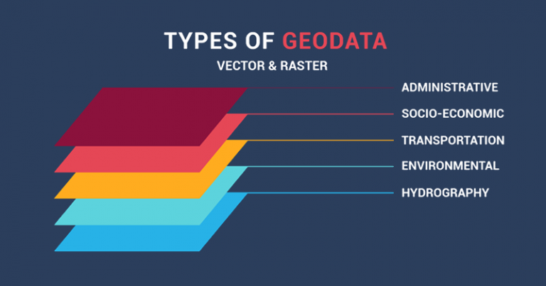
Geodata Themes
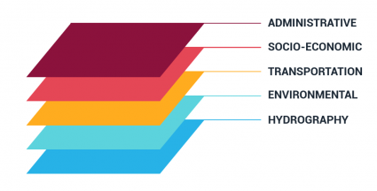
The truth is that you can group geodata into as many themes as you want.
They can be as broad or as narrow as your liking.
Here are examples of geographic themes:
Cultural
- Administrative Data:
- Boundaries: Information about political boundaries, administrative divisions, and jurisdictions at various levels (national, regional, local).
- Cities and Urban Planning: Data related to city layouts, zoning regulations, land use, and urban development plans.
- Administrative Centers: Locations of government offices, administrative buildings, and public service facilities.
- Socioeconomic Data:
- Demographics: Information about population characteristics, such as age, gender, ethnicity, and education levels.
- Economy: Data on economic indicators, employment rates, industries, businesses, and economic activity.
- Crime and Public Safety: Geospatial data related to crime rates, law enforcement presence, and public safety initiatives.
- Transportation Data:
- Roads and Highways: Mapping road networks, types of roads, and transportation corridors.
- Railways: Locations of railway tracks, stations, and transportation hubs.
- Airports and Ports: Data on airports, seaports, heliports, and their infrastructure.
- Public Transportation: Information about bus routes, subway lines, and other public transportation options.
- Healthcare and Social Services:
- Healthcare Facilities: Locations of hospitals, clinics, medical centers, and healthcare services.
- Social Services: Mapping social service centers, community centers, shelters, and support organizations.
- Education and Research:
- Educational Institutions: Data on schools, universities, colleges, research centers, and educational facilities.
- Research Institutes: Locations of research institutions, libraries, and scientific organizations.
- Recreational and Cultural Amenities:
- Parks and Recreation Areas: Mapping parks, green spaces, recreational facilities, and outdoor amenities.
- Cultural Venues: Data on theaters, music venues, cinemas, and cultural attractions.
- Infrastructure and Utilities:
- Utilities: Information about water supply, electricity, gas, and telecommunications infrastructure.
- Infrastructure Projects: Data on ongoing and planned infrastructure projects, such as roads, bridges, and public facilities.
- Land Ownership and Use:
- Land Tenure: Data on land ownership, land use regulations, and property rights.
- Agricultural Zones: Mapping agricultural areas, farmlands, and crop distribution.
- Emergency Services and Disaster Response:
- Fire Stations and Police Stations: Locations of emergency service facilities.
- Disaster Response Centers: Data on disaster management and emergency response hubs.
Physical
- Environmental Data:
- Agriculture and Croplands: Data on agricultural land use, crop types, irrigation, and farming practices.
- Climate Data: Mapping climate zones, temperature patterns, precipitation levels, and climate change indicators.
- Hydrography Data:
- Oceans and Seas: Mapping ocean currents, marine ecosystems, underwater features, and maritime boundaries.
- Lakes and Reservoirs: Data on the locations and sizes of lakes, reservoirs, and water bodies.
- Rivers and Waterways: Information about river courses, watersheds, and river-related infrastructure.
- Elevation Data:
- Terrain and Topography: Mapping landforms, slopes, and elevation changes in the landscape.
- Relief and Contours: Data on elevation contours, hillshade models, and relief visualization.
- Land Cover and Land Use:
- Vegetation Types: Mapping different types of vegetation, forests, grasslands, and ecosystems.
- Urban Areas: Data on built-up areas, urban sprawl, and suburban development.
- Geological and Geophysical Data:
- Geological Formations: Mapping geological features, rock formations, and geological hazards.
- Earthquake Data: Locations of earthquake epicenters, fault lines, and seismic activity.
- Mineral Resources:
- Mineral Deposits: Data on locations of valuable minerals, ores, and mineral extraction sites.
- Mining Operations: Mapping active and historical mining sites and quarries.
- Water Resources:
- Groundwater Aquifers: Data on underground water sources and aquifer locations.
- Water Bodies Classification: Mapping freshwater bodies, wetlands, and coastal zones.
- Air Quality and Pollution:
- Air Quality Monitoring Stations: Locations of monitoring stations for air pollutants.
- Pollution Hotspots: Mapping areas with high pollution levels, industrial emissions, and smog.
- Natural Hazards:
- Flood Zones: Data on flood-prone areas, floodplains, and riverine flooding risk.
- Tsunami Vulnerability: Mapping coastal areas susceptible to tsunamis and tidal waves.
- Ecological Habitats:
- Biodiversity Hotspots: Locations of areas with high biodiversity and unique ecosystems.
- Protected Areas: Data on national parks, wildlife reserves, and conservation zones.
- Glaciers and Polar Regions:
- Glacial Extent: Mapping glaciers, ice caps, and polar ice sheets.
- Polar Stations: Locations of research stations in Arctic and Antarctic regions.
- Hydrology and Watersheds:
- Watershed Boundaries: Mapping boundaries of watersheds and drainage basins.
- River Networks: Data on river networks, tributaries, and streamflow patterns.
- Soil Type and Degradation:
- Soil Types and Characteristics: Information about soil composition, soil fertility, and soil erosion susceptibility.
- Erosion Risk Areas: Mapping areas prone to soil erosion and degradation.
- Soil Salinity: Data on regions with high soil salinity and its impact on agriculture.
Sources for Geodata
Are you trying to find open, authoritative geodata to use in your maps? Before the concept of open data took off, organizations were protecting data as if it were Fort Knox. Since then, we are in a much better position.
Currently, there’s no single website that holds all the geodata in the world. Instead, they branch out into what they are most specialized in.
For example, OpenStreetMap data is the largest crowd-sourced GIS database in the world providing countless applications for the public.
From NASA and USGS to the United Nations, these 10 free GIS data sources list the best vector and raster to boost your geodata repertoire.
Finally, over 1000 satellites orbit the Earth collecting imagery of our planet. These 15 free satellite imagery sources give you the most up-to-date bird’s eye view of it all.


very nice lesson so thank you so much
Good, thanks
Excelente información, gracias por la publicación.