An Introduction to Web Mapping Services (WMS)

DEFINITION:
WMS (Web Mapping Service) is a standard way to share maps over the internet. Other related services include WFS, WCS, WPS, WMTS, and WCPS.
What is a Web Mapping Service (WMS)?
A web mapping service (WMS) consists of geospatial data hosted through the Internet with standards set by the Open Geospatial Consortium (OGC).
WMS enables the exchange of spatial information and viewing over the web in the form of a map or image to your web browser.
There are many different types of web mapping services. For example, some of the most common formats are WMS, WFS, WCS, WPS, WMTS, and WCPS.
But what are the differences between them? And what are the benefits and limitations of each type? Read on to find out how you can choose the best web service for your needs.
Web Mapping Service (WMS)
A Web Mapping Service (WMS) is the most widely used and most straightforward form for displaying GIS data on the web. It offers a variety of benefits, including the ability to provide a geospatial view of your GIS data.
A WMS provides data as a visual representation through the internet with basic querying options. A WMS gives basic zooming, panning and assists organizations to serve GIS data as images with quick rendering speeds.
You should choose a WMS service for any of the following options:
- Render data quickly
- Perform basic querying
- Produce simple maps
- Maintain styles when published
Overall, a WMS allows people to view information about their own geographic locations based on the OGC standards for WMS.
Web Feature Service (WFS)
A Web Feature Service (WFS) provides essential tools for businesses and individuals who want to create interactive maps with a variety of features including search capabilities, filtering, sorting options, and more.
If you want to perform any type of action such as editing data, a WFS gives you access to vector data (not raster). By using the GetFeatures request, you will be able to retrieve features for advanced features, and much more.
It’s recommended to use a WFS in any of the following circumstances:
- Create, manipulate, and delete features
- Perform advanced querying to retrieve feature information
- View and edit attribute table records
If you want access to the features so you can manipulate them in any way, a WFS is the best way to go. This type of mapping service follows the OGC standards for WFS.
Web Coverage Service (WCS)
A Web Coverage Service (WCS) is similar to a WFS. Instead, you can request multidimensional raster data. For instance, you can use it for satellite imagery, aerial photography, elevation hillshades, or temperature grids.
The term WCS originates from gridded coverages, which refer to any type of raster-based image. Although this type of format is less common compared to a WMS or WFS, it works well for satellite imagery or any type of raster image.
You’ll want to use a WCS in any of the following circumstances.
- Represent multidimensional formats like netCDF, HDF, or GRIB
- Contains multi-year data like temperature data
- Analyze raster data
The WCS standard is not as common as other web services. But the OGC standards of WCS define the protocol for using it.
Web Processing Service (WPS)
When you want to serve and execute a geoprocessing tool for access across a network, it’s the Web Processing Service (WPS) that defines all the inputs and outputs to perform a GIS operation.
For example, geoprocessing services can include anything from overlay, proximity, and routing tools based on the standardized WPS XML schema related to geospatial data.
Here are the following situations you may want to use a Web Processing Service (WPS).
- Perform geospatial analysis for anyone without the proper software
- Accept a standard set of inputs and outputs
- Simplify a spatial operation as a widget in a web map
The OGC standards for the WPS define a protocol for inputs and outputs for geo-algorithms.
Web Map Tile Service (WMTS)

A Web Map Tile Service (WMTS) is a relatively newer standard web service developed in 2010. The idea for this type of web service is similar to a WMS. But it’s a protocol designed for a 2D tiled schema that is 256 x 256 pixels in size.
One of the benefits of using a WMTS is that it can be pre-rendered on the server-side map tiles at different scales and cached on the client side. As a result, this results in faster delivery, less bandwidth, and a better user experience for its quick loading.
You may want to consider using a WMTS in any of the following situations:
- Provide optimal speed for viewing cached image tiles
- Display large amounts of data over the internet but has limited capability for analysis
- Serve base maps with optimal performance
To learn more about the OGC WMTS protocol, you can find out more about its schema from the Open Geospatial Consortium.
Web Coverage Processing Service (WCPS)
The Web Coverage Processing Service (WCPS) was developed in 2008 and is a mix of WCS and WPS. The primary usage of the WCPS standard is for multi-dimensional coverages such as sensor data, imagery, or statistical analysis.
Although this format has a role in remote sensing imagery, it goes beyond a simple coverage grid (WCS). For example, you can use a WCPS to calculate Normalized Difference Vegetation Index (NDVI) values from a multi-spectral satellite.
Even though it’s not as popular as the other web service standards, here are some of its users.
- Extract and analyze server-side multi-dimensional coverage repositories
- Perform an advanced 4-D climate model with multi-dimensional data
- Provide extra flexibility for preprocessing and data reduction
The OGC WCPS protocol is one of the newer types of web services available but is less useful than others.
Differences between WMS, WFS, WCS, WPS, WMTS, and WCPS
Here is a table that outlines the characteristics of various web services used in geospatial applications:
| Service | Acronym | Purpose | Data Type Support | Example Use Cases |
|---|---|---|---|---|
| Web Mapping Service | WMS | Serve maps as images for visualization | Maps, Layers, Images | Displaying maps with layers and symbology |
| Web Feature Service | WFS | Serve geospatial features for querying | Vector Features | Retrieving, querying, and editing geographic features |
| Web Coverage Service | WCS | Serve multi-dimensional data (rasters) | Raster Data | Accessing and analyzing raster data |
| Web Processing Service | WPS | Execute geospatial processes remotely | Geoprocessing Tasks | Running geospatial analyses and algorithms |
| Web Map Tile Service | WMTS | Serve pre-rendered map tiles for speed | Maps, Layers | Efficiently displaying maps with cached tiles |
| Web Coverage Processing Service | WCPS | Execute complex operations on raster data | Raster Data | Advanced analysis and processing of raster coverages |
These web services are useful in sharing, analyzing, and visualizing geospatial data and processes over the Internet. Each service is tailored to specific tasks and data types, enhancing the capabilities of geospatial applications and systems.
Where do web mapping services fit into GIS Servers
It’s important to understand that a WMS, WFS, WPS, or any type of web mapping service is output from a GIS Server such as Geoserver or ArcGIS Server.
For instance, a GIS server reads inputs from a variety of GIS formats. For example, it can read from PostGIS, ArcSDE, Shapefiles, Geopackages, or raster data.
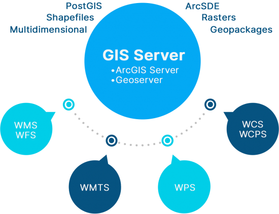
Then, it outputs the data as a web service such as a WMS or WFS, which are the two primary geospatial web services. There are a number of different types of mapping services. But all serve their own purpose.
Remember that a web mapping service is not only designed for the internet. But can also integrate seamlessly with other software applications such as GIS (geographic information systems).
Open Geospatial Consortium (OGC)

The role of the Open Geospatial Consortium (OGC) is they are like the “keepers of geospatial data standards”, free and available for no cost.
No matter the source of the data, OGC helps geospatial data integrate with each other. If it comes from different sensors, software, and even different languages, OGC sets the standards for sharing data so everyone can communicate.
Basically, OGC helps so all servers, sensors, and any geospatial data formats speak the same language of “where”.
Any type of web service (WMS, WFS, WCS, etc) is primarily available through interfaces that support Open Geospatial Consortium (OGC) geospatial standards.
Web mapping services applications
Web services have a variety of purposes including any of the following:
There are countless ways to implement a web service. But each one has its own advantages and disadvantages.
An Introduction to Web Mapping Services (WMS)
Web mapping services have been revolutionized by the strides made in technology, and now you can serve almost any type of GIS data on the web.
Whether you want to build a web service for simple display, editing features, or even to perform a geoprocessing operation, you can with a web mapping service.
But with so many options available to us (WMS, WFS, etc), we can choose what type of web service best suits our needs.
We hope this introduction to web mapping services has clarified the benefits and limitations of each type of service. If you have any questions, please send us your comments below.


1. Is it possible to use WMS data in an offline machine?
2. One the WMS service is downloaded, where does this data reside on a Linux machine?
Sorry, I’ve never done it before. Let me know if it’s possible.