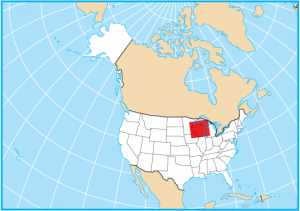
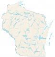
Wisconsin County Map

About the map
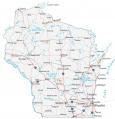
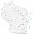
This Wisconsin county map displays its 72 counties. Wisconsin’s tally of 72 counties makes it the 19th highest in the United States. Major counties in Wisconsin include Milwaukee County, Dane County, and Waukesha County.
For size, Marathon County is the largest county with an area of about 1576 square miles. Then, Bayfield, Marinette, and Sawyer County are the next largest. On the other hand, the smallest county in Wisconsin is Ozaukee County right next door to Milwaukee County. Ozaukee County occupies an area of just 234 square miles.
The most populous county in Wisconsin is Milwaukee County, which has close to 950,000 people. Its population makes it 53rd among all counties in the United States. Conversely, Florence County is the least populated in Wisconsin with less than 4500 residents.

You are free to use our county map of Wisconsin for educational and commercial uses. Attribution is required. How to attribute?
Wisconsin County List
| FIPS Code | Name | Land (sq mi) | Water (sq mi) | Population (2024) |
|---|---|---|---|---|
| 55-001 | Adams County | 645.7 | 41.8 | 21,352 |
| 55-003 | Ashland County | 1045.0 | 1247.4 | 16,196 |
| 55-005 | Barron County | 863.0 | 26.7 | 46,810 |
| 55-007 | Bayfield County | 1477.9 | 563.8 | 16,838 |
| 55-009 | Brown County | 530.1 | 85.6 | 273,909 |
| 55-011 | Buffalo County | 675.8 | 33.8 | 13,464 |
| 55-013 | Burnett County | 821.6 | 58.7 | 17,187 |
| 55-015 | Calumet County | 318.3 | 78.8 | 53,602 |
| 55-017 | Chippewa County | 1008.4 | 32.9 | 67,323 |
| 55-019 | Clark County | 1209.7 | 9.0 | 34,801 |
| 55-021 | Columbia County | 765.5 | 30.4 | 58,113 |
| 55-023 | Crawford County | 570.6 | 28.6 | 16,008 |
| 55-025 | Dane County | 1196.5 | 41.0 | 588,347 |
| 55-027 | Dodge County | 875.7 | 31.4 | 88,635 |
| 55-029 | Door County | 482.0 | 1888.3 | 30,512 |
| 55-031 | Douglas County | 1304.3 | 175.4 | 44,276 |
| 55-033 | Dunn County | 850.2 | 13.7 | 46,135 |
| 55-035 | Eau Claire County | 637.9 | 7.3 | 108,830 |
| 55-037 | Florence County | 488.1 | 9.3 | 4,673 |
| 55-039 | Fond du Lac County | 719.6 | 46.3 | 104,269 |
| 55-041 | Forest County | 1014.2 | 32.3 | 9,506 |
| 55-043 | Grant County | 1146.9 | 36.5 | 52,330 |
| 55-045 | Green County | 584.0 | 0.5 | 37,183 |
| 55-047 | Green Lake County | 349.5 | 30.6 | 19,370 |
| 55-049 | Iowa County | 762.7 | 5.4 | 23,963 |
| 55-051 | Iron County | 758.2 | 161.0 | 6,235 |
| 55-053 | Jackson County | 987.2 | 13.3 | 21,027 |
| 55-055 | Jefferson County | 556.5 | 26.3 | 86,245 |
| 55-057 | Juneau County | 767.0 | 38.1 | 26,590 |
| 55-059 | Kenosha County | 271.9 | 482.2 | 168,754 |
| 55-061 | Kewaunee County | 342.5 | 741.8 | 20,751 |
| 55-063 | La Crosse County | 451.8 | 28.2 | 121,060 |
| 55-065 | Lafayette County | 633.6 | 1.0 | 17,306 |
| 55-067 | Langlade County | 870.7 | 17.1 | 19,535 |
| 55-069 | Lincoln County | 878.7 | 28.1 | 28,461 |
| 55-071 | Manitowoc County | 589.3 | 904.8 | 81,513 |
| 55-073 | Marathon County | 1545.3 | 31.1 | 139,091 |
| 55-075 | Marinette County | 1399.4 | 150.5 | 42,343 |
| 55-077 | Marquette County | 455.7 | 8.8 | 15,743 |
| 55-078 | Menominee County | 357.6 | 7.3 | 4,286 |
| 55-079 | Milwaukee County | 241.5 | 948.0 | 924,740 |
| 55-081 | Monroe County | 900.9 | 7.2 | 46,370 |
| 55-083 | Oconto County | 997.5 | 151.4 | 40,037 |
| 55-085 | Oneida County | 1113.9 | 122.6 | 38,175 |
| 55-087 | Outagamie County | 637.6 | 7.0 | 195,390 |
| 55-089 | Ozaukee County | 233.0 | 883.2 | 93,956 |
| 55-091 | Pepin County | 232.0 | 16.7 | 7,555 |
| 55-093 | Pierce County | 573.9 | 18.0 | 43,380 |
| 55-095 | Polk County | 914.1 | 42.3 | 45,831 |
| 55-097 | Portage County | 800.9 | 21.9 | 72,040 |
| 55-099 | Price County | 1254.0 | 24.0 | 14,087 |
| 55-101 | Racine County | 332.6 | 459.6 | 198,651 |
| 55-103 | Richland County | 586.1 | 3.1 | 17,123 |
| 55-105 | Rock County | 718.1 | 8.0 | 165,461 |
| 55-107 | Rusk County | 913.5 | 17.3 | 14,168 |
| 55-109 | St. Croix County | 722.4 | 13.2 | 97,954 |
| 55-111 | Sauk County | 831.5 | 17.6 | 66,486 |
| 55-113 | Sawyer County | 1257.6 | 92.6 | 18,835 |
| 55-115 | Shawano County | 893.2 | 16.2 | 41,299 |
| 55-117 | Sheboygan County | 511.5 | 759.7 | 118,331 |
| 55-119 | Taylor County | 975.0 | 9.5 | 20,167 |
| 55-121 | Trempealeau County | 733.0 | 9.0 | 30,801 |
| 55-123 | Vernon County | 791.6 | 24.8 | 31,351 |
| 55-125 | Vilas County | 857.7 | 160.0 | 23,948 |
| 55-127 | Walworth County | 555.4 | 21.2 | 106,029 |
| 55-129 | Washburn County | 797.1 | 56.2 | 16,982 |
| 55-131 | Washington County | 430.6 | 5.0 | 138,727 |
| 55-133 | Waukesha County | 549.7 | 30.8 | 417,029 |
| 55-135 | Waupaca County | 747.7 | 17.5 | 51,171 |
| 55-137 | Waushara County | 626.2 | 11.2 | 25,079 |
| 55-139 | Winnebago County | 434.7 | 143.9 | 173,307 |
| 55-141 | Wood County | 793.0 | 16.2 | 73,943 |
According to your numbers, Pepin County is actually the smallest county by land area.
I guess it depends if you include water vs land area.
It’s the smallest with or without water included.