How to Fill NoData for Raster Data
How to Fill NoData for Raster Data
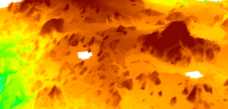
There are a couple of options to fill NoData cells for a raster image.
ArcGIS Generalization toolset has the “nibble” and “expand” tools to fill in NoData holes.
If you have a raster with gaps in it, you can use the open-source software QGIS with the GDAL Fill NoData tool
The quickest (and dirtiest) method is using the free SAGA GIS software’s Close Gaps tool. (It’s worth it to download because of how quickly you can get this done.)

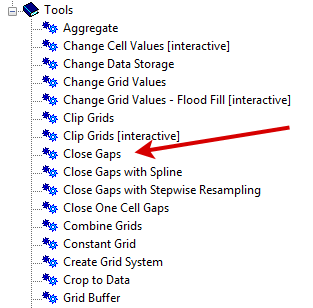
SAGA GIS Close Gaps Tool
Don’t get turned off downloading another software package because this will probably be a much quicker method than what you will find in the next 10 minutes. SAGA GIS is completely open-source. It comes with a wide spectrum of useful tools for geoscientific analysis.
With a bit of trial and error, we’ve found the most effective way to fill in NoData cells is using the Close Gaps tool.
You can find the Close Gaps tool in the Grid toolbox.
Change the input raster to your DEM or any raster data set with holes.
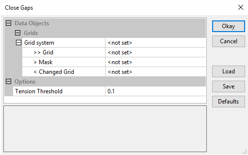
Click the Okay button and you’re done.
That’s all there is to it.
What’s Next?
While ArcGIS lets you nibble and expand to eat away at NoData holes.
SAGA GIS gets the job done – quick and dirty.
Download SAGA GIS and give this tutorial a try.
Remember this tip next time you have gaps and want to replace NoData values in a raster data set.


Hi there, I am suffering from the same issue and tried to use your method to fill the gap in my raster but SAGA goes un respond and for reason, there is no output I will be happy if you could provide an example that how could we fill the gap in our raster?
did not work
Do you know what interpolation SAGA uses?