GIS Analyst Job: What to Expect
GIS analysts are well-rounded, tech-saavy spatial individuals with a wide range of skills. They are multi-tasking, multi-disciplinary and fast-on-their-feet.

GIS analysts are well-rounded, tech-saavy spatial individuals with a wide range of skills. They are multi-tasking, multi-disciplinary and fast-on-their-feet.
The focus of uDig (User-friendly Internet GIS) is placed on database viewing and editing as well as a rich collection of GIS functionality.
Ellipsoids, survey benchmarks and triangulation – these are the ingredients for geodetic datums. NAD27, NAD83 and WGS84 are common datums in North America.

Imagine you can earn a GIS online certificate at some of the best institutes in the world without leaving your country… or even the comfort of your own home.
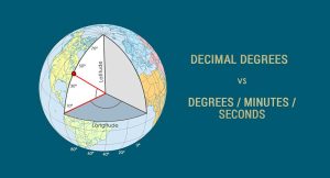
We can find any location on Earth using latitude and longitude coordinates. And we measure those coordinates with decimal degrees or degrees/minutes/seconds

If your letters and words are all uppercase or lowercase in a field, and you want to capitalize the first letter of each word, use this Python code block.

When selective availability was enabled, this added 50 meters of error horizontally and 100 meters vertically to GPS signals.

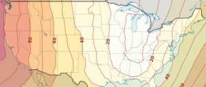
The Greenwich Meridian (or Prime Meridian) is a zero degrees longitudinal It is the start-point which we measure 180 degrees east and west.

From A to Z, we deliver stunning visualizations and meanings with the GIS Dictionary – Definition Glossary. Sharpen your skills with new GIS terminology.

Dark object subtraction, radiative transfer models and atmospheric modelling are common techniques used to for atmosphere correction in remote sensing.