Greenwich Meridian (Prime Meridian)

What is the Greenwich Meridian?
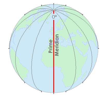
Longitude lines like the Greenwich Meridian run north-south and converge at the poles.
Lines of longitudes run between -180° and +180°. But there’s a special longitudinal line where all x-coordinates start at 0°.
This special north-south line is where we measure east and west and is the Prime Meridian.
We also call it the Greenwich Meridian because it runs through Greenwich, England.
Greenwich Meridian (Prime Meridian)
Everywhere on Earth has a position because we can assign them geographic coordinates. We measure these coordinates as lines of latitude and longitude.
The 0° line of longitude starts at the Prime Meridian. It’s also called the Greenwich Meridian because it runs through Greenwich, England. Then, we can measure 180° to the west or 180° to the east.
Lines of latitude start at the equator. Everything above the equator is from 0-90° north. But everything below the equator is from 0-90° south.
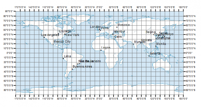
Latitudes and longitudes make up our geographical coordinate system. For example, WGS84, NAD83, and NAD27 are common coordinate systems.
Geographic Coordinate Systems (GCS)
We use an ellipsoid to approximate the surface of Earth. It’s not a perfect sphere because it flattens a bit at the poles. Then, we use the ellipsoid to reference all latitude and longitude coordinates to it.
A datum describes the shape of the Earth in mathematical terms. Each datum specifies:
- Radius
- Inverse flattening
- Semi-major and semi-minor axis
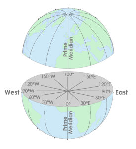
Longitudes:
X-coordinates are between -180° and +180°, which are called longitudes.
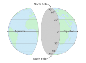
Latitudes:
Y-values are between -90° and +90° degrees, which are lines of latitudes.
Coordinates pairs (X, Y) represent positions in two-dimensional space. But triplets (X, Y, Z) also contain a height value for elevation.
While the X-value represents the east-west position, the Y-value represents the north-south position. The Z-value generally refers to the elevation at that point location.
Summary: Greenwich Meridian (Prime Meridian)
The 0-degree line of longitude that passes through the Royal Observatory in Greenwich, England is the Greenwich Meridian.
It’s also called the Prime Meridian.
This line is the starting point for longitudinal lines that run north-south and converge at the poles.
The Greenwich Meridian (or prime meridian) is a 0° line of longitude from which we measure 180° to the west and 180° to the east. These measurements are the basis of our geographic reference grid.


Please assist. I’m seeking the location of the country Mexico in longitude and latitude coordinates
Although Mexico is a large country… Mexico City is roughly a central point for reference: Latitude 19.4326° N, Longitude -99.1332° W.
Beautiful article! Thank you!
I want to stand on the prime meridian line at N Greenwich in the UK, then go to France, Spain, Algeria, Ghana, Mali, Togo, Burkina Faso Countries falling on S of the prime meridian. Touring countries falling on the prime meridian.
Thank you for this tour, I’m studying GIS, and this was helpful in understanding geographic coordinate systems.
Really enjoyed this site. I learned so much more about what we saw.
I would love to see more pictures of the area described above
My husband and I took a small motor boat up the river to Greenwich, England to the Royal Observatory Greenwich. While there we stood directly on the Prime Meridian Line. (So Neat) just to be there. The tour in the Observatory seeing all the clocks from the beginning when it developed was so wonderful.