GIS Analyst Job: What to Expect

What does it take to be a GIS analyst?
A GIS analyst is a well-rounded, tech-savvy spatial individual with a wide range of skills. Also, they are multi-tasking, multi-disciplinary, and fast on their feet. Companies hire GIS analysts to:
- Create geospatial data sets
- Prepare maps for publication
- Monitor and administer databases
But GIS analysts also often prepare reports, perform research, and give professional opinions. As a GIS analyst, you could be working in almost every discipline for spatial data management.
For example, local and national governments use GIS to manage infrastructure, land records, economic development, and much more. Let’s get started looking at the exciting job of being a GIS analyst.
How do GIS analyst salaries stack up?
As you can see in the salary pyramid, GIS analysts are in the 60,000 to 75,000$ USD range. But of course, it depends on your location. Also, it depends if you work in an urban or rural environment.
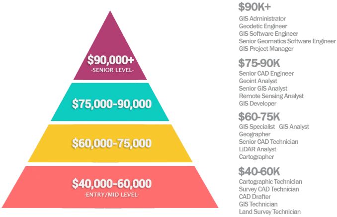
Similar to GIS technicians, GIS analysts are entry positions. After you get your foot in the door, you can climb the GIS career ladder. For example, GIS analysts often transition into management and programming. There are also specialized fields like photogrammetry, LiDAR, and remote sensing.

In terms of total jobs in the field of GIS, 25% of jobs in the United States have the title “GIS Analyst”[1]. Similar to GIS technicians, this job type integrates well with CAD and engineering.
The pros and cons of GIS analyst jobs
GIS analysts are fairly satisfied with their line of work. Often, GIS analysts enjoy their workplace diversity. For example, you will rarely be doing the same monotonous tasks week after week. Unless you are in a digitizing type of role, you often create maps, write code, and are challenged daily.
As new and innovative technologies pave their way into GIS, this only means more growth in the field. Because of the youth of GIS as a discipline, there are always exciting new developments in GIS. For example, web map platforms like ArcGIS Online have really taken off over the last couple of years.

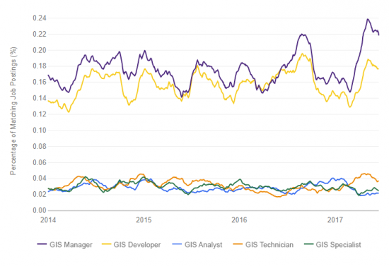
According to Indeed job trends, GIS analysts are less in demand than GIS developers and managers. Often the case, GIS analysts are similar to technicians and specialists with just a different job title. (So you should sum each percent for each role on the line graph below)
Often, GIS analysts are unhappy with a relatively low salary of pay compared with IT. Because GIS analysts are routinely burdened with a diverse workload and new technology, wages aren’t keeping up.
As a disadvantage, GIS analysts sometimes express dissatisfaction about limited career growth. Unless you move into a project management role, there aren’t a lot of other opportunities to pursue.
What are the job duties of a GIS analyst?
Here are some of the typical job duties for a GIS analyst:
CARTOGRAPHY is the study of creating maps. As a GIS analyst, cartography comes in different forms. For example, it could be softcopy mapping, web mapping, or digital maps. For these mapping products, you may have to suggest design and quality control/assurance.
DATABASE MANAGEMENT stores vector and raster data in a relational database management system. Because databases can grow exponentially in size, you may have a role in database administration type of role.
SPATIAL ANALYSIS uses techniques to manipulate, extract, locate and analyze geographic data. GIS analysts use geoprocessing tools and data analysis to explore the relationships between map features.
PROGRAMMING automates redundant GIS processes so companies implement workflows and GIS modeling techniques for normal business operations. For example, typical programming languages in GIS are Python, SQL, JavaScript, C++, Visual Basic, and Java.
Complementary duties
You may or may not have to perform these complementary duties:
REMOTE SENSING: This is the process of using satellite data to classify land cover. Even if you don’t use remote sensing, you probably will do air photo interpretation or use global positioning systems (GPS).
SURVEYING accurately measures three-dimensional points on the land with measuring equipment. Although GIS analysts don’t tend to be in the field often, they manage data collected by surveyors and field staff.
BUSINESS DEVELOPMENT involves project management, technical writing, and team management. Senior GIS analysts can take on a larger role by leading teams and providing opportunities for business development.
What are examples of everyday GIS analyst tasks?
Here are some tasks that you might have to perform as a GIS analyst:
- Develop and maintain GIS data resources for public access.
- Assist with data collection with GPS and field collection with Esri Collector or QField.
- Digitize, create, maintain, display, and update GIS databases to various GIS databases.
- Produce accurate maps and other representations of data for public use and fieldwork activity.
- Ensure data accuracy by going out in the field to resolve conflicts.
- Record and document details of map updates, additions, or deletions.
- Being proficient with Esri ArcGIS 10x with extensions Network Analyst, 3D Analyst, and Spatial Analyst.
- Non-Esri or open source software includes AutoDesk AutoCAD, QGIS, GRASS, CARTO, and Mapbox.

What’s next?
GIS analysts are more than just map makers. For example, it’s common to have some proficiency in remote sensing, CAD, programming, and database management.
And it’s hard to get away with primarily being just THE GIS analyst in your workplace without having a complementary area of expertise.
Whether you’re in environmental protection, transportation, or military intelligence, GIS is often a skill that complements the field you’re working in.
Furthermore, it often requires additional education on top of just GIS. If you’re thinking twice about becoming a GIS analyst, take a look at some of our other job profiles in GIS.
References
1. GIS Certification Institute (GISCI). (2020. January). Retrieved from https://www.gisci.org/


l am student of Master Geography and GIS
I am looking for job regarding Geographical information Systems. I have one year experience in Geographical information Systems.
Thank you so much, I want to study Geographic Information Systems
Thanks for this useful information…I’m pursuing Geospatial Information Science
Very useful information for me. Thank you very much
Thank you for your valuable information.
I am a GIS student and I intend to explore the field
Thank so much for a valuable information
There is also some web mapping and GIS server management and administration that is required of many GIS Analysts. You definitely don’t want to have to wait in the office for someone else to turn something on when staff are waiting for their web maps :-).
Also, a major challenge in any work environment (and this primarily applies to organizations that have not yet fully developed their GIS potential) is reporting to people who have no clue what GIS is, or how it can best be utilized. If one reports to a manager who thinks that GIS is only used to make pretty paper maps, and that manager is convincing other managers that this is true, well, one’s years of GIS experience and skills will typically go to waste, and the job will be incredibly boring.