Degrees/Minutes/Seconds (DMS) vs Decimal Degrees (DD)
For positioning, we can find any location on Earth using latitude and longitude coordinates.
And we measure those coordinates using decimal degrees or degrees/minutes/seconds.
While latitude lines range between -90 and +90 degrees, longitude coordinates are between -180 and +180 degrees.
Do you notice how we use degrees for latitude and longitude coordinates? Let’s start with some key examples of how we use angular units.
A Review on Geographic Coordinate Systems
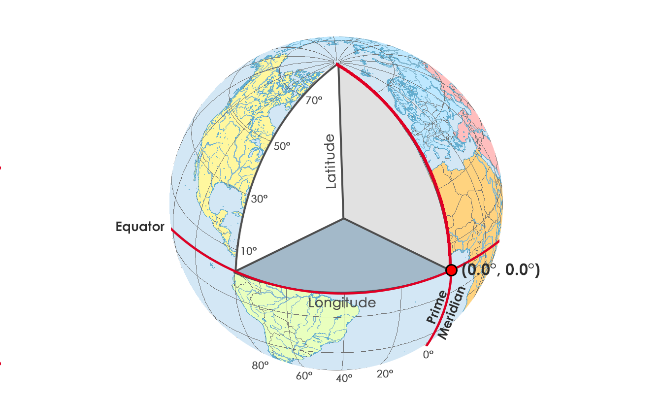
In a geographic coordinate system (GCS), we can reference any point on Earth by its longitude and latitude coordinates. Because a GCS uses a sphere to define locations on the Earth, we use angles measured in degrees from the Earth’s center to any point on the surface.
The coordinates (0°N, 0°E) are where the equator and prime meridian cross. The funny thing is that if you look at this location on a map, it’s all ocean.
But because GIS professionals sometimes mistakenly define their project when adding XY coordinates, (0°N, 0°E) had turned into a fictional location called Null Island.
When we move northward along the prime meridian, the longitude value stays fixed at 0°. But the latitude angle and coordinate increase because we move northward.
If we move northwards at an angle of 51.5°, this positions you on the Royal Observatory in Greenwich, England as pictured below. Actually, this is why the 0° line of longitude is the reference starting point. From the Greenwich Meridian, we can find positions east and west.
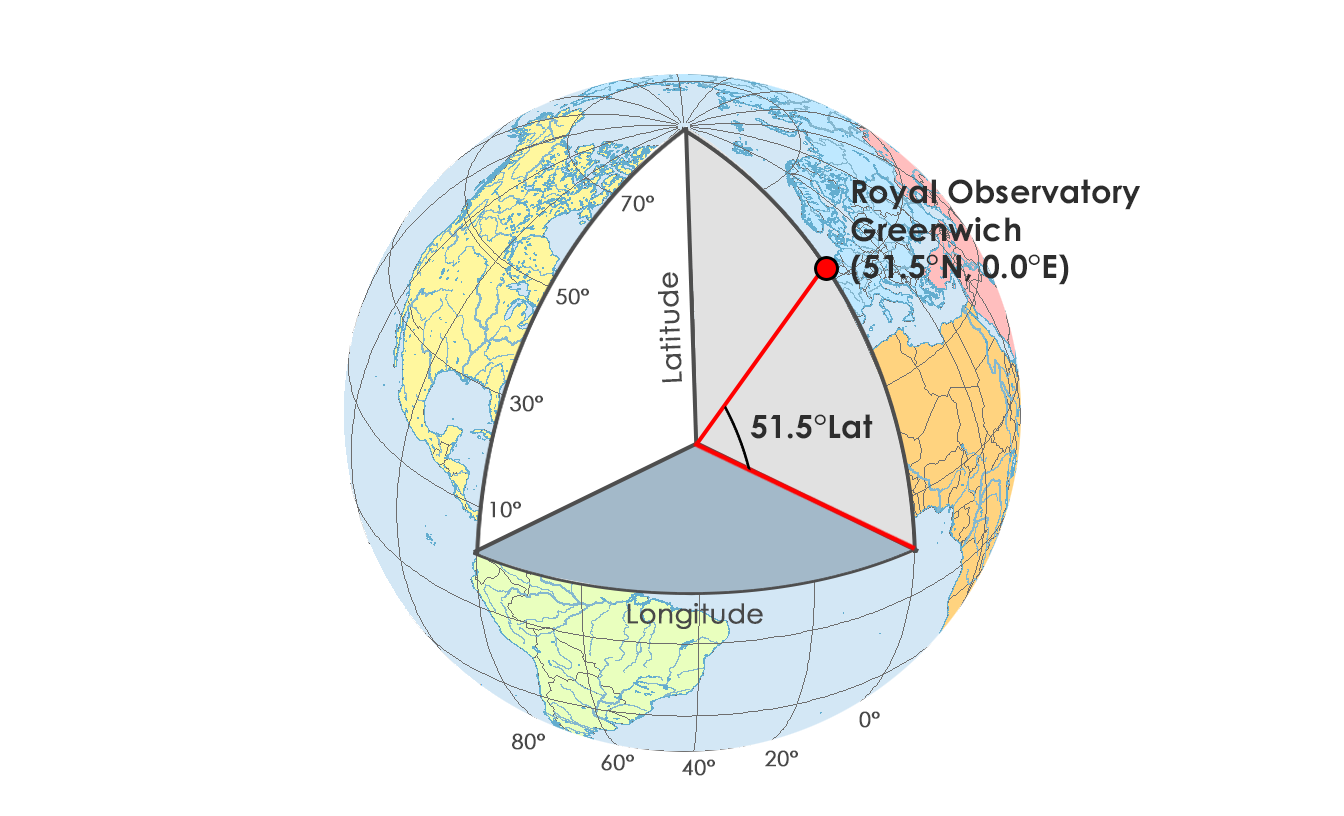
Because the prime meridian is the 0° starting point for longitude coordinates, everything is referenced from here.
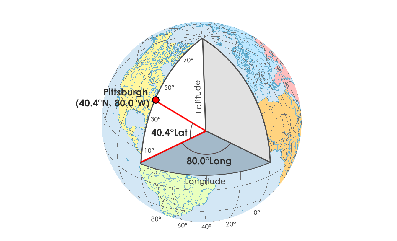
For example, we can change the angle to 80.4° west. This moves us 80.4°W away from the prime meridian. And just by chance, Pittsburgh is located on this line of longitude at about (40.4°N, 80.4°W)
To recap:
The equator is 0° latitude where we measure north and south. This means that everything north of the equator has positive latitude values. Whereas, everything south of the equator has negative latitude values.
Alternatively, the Greenwich Meridian (or prime meridian) is a zero line of longitude from which we measure east and west.
Decimal Degrees vs Degrees/Minutes/Seconds
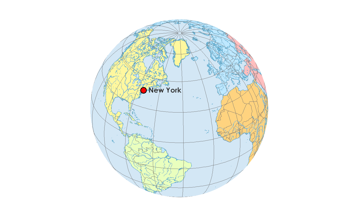
One way to write spherical coordinates (latitudes and longitudes) is using degrees-minutes-seconds (DMS). Minutes and seconds range from 0 to 60. For example, the geographic coordinate expressed in degrees-minutes-seconds for New York City is:
LATITUDE: 40 degrees, 42 minutes, 51 seconds N
LONGITUDE: 74 degrees, 0 minutes, 21 seconds W
But you can also express geographic coordinates in decimal degrees. It’s just another way to represent that same location in a different format. For example, this is New York City in decimal degrees:
LATITUDE: 40.714
LONGITUDE: -74.006
Although you can easily convert coordinates by hand, the FCC has a DMS-Decimal converter tool that can convert between decimal degrees and degrees/minutes/seconds.
Try For Yourself
When you put two coordinates together as a pair (X, Y), you can locate anything on Earth with a geographic coordinate system.
Anything!
You can express coordinates in primarily two different ways. For example, you can use decimal degrees or degrees-minutes-seconds. But there are even new growing ways of addressing the world such as What3Words.
After your locations are in a GCS, geographers often project their locations in a Projected Coordinate System (PCS). PCS like the State Plane Coordinate System (SPCS) or Universal Transverse Mercator (UTM) are always based on a GCS that is based on a sphere.
Learn more about map projections and how to project your data.


I’m wrestling with longitude/latitude formats as used by the aviation industry, i.e. pilots. Your page https://gisgeography.com/decimal-degrees-dd-minutes-seconds-dms/ is helpful. Yet, I’ve found this resource which I presume is widely used by pilots: http://www.airnav.com/airport/ksle which displays coordinates in a different syntax:
RUNWAY 13
Latitude: 44-55.012342N
Longitude: 123-00.435210W
AirNav’s syntax looks to be [Degrees]-[Minutes].[Seconds][Bearing Letter] using the dash and period a delimiters followed by a letter.
I submitted AirNav’s coordinates to https://www.fcc.gov/media/radio/dms-decimal parsed as follows:
latitude box 1: 44
latitude box2: 55
latitude box3: 0.01234
longitude box1: -123
longitude box2: 0
longitude box3: 0.43521
and the page calculated:
latitude: 44.91667 and longitude: -123.000121
(The FCC’s site limited the decimal precision, and I found using the decimal results, the runway was in the nearby pond.)
In view of the above, it would be helpful to point out that the syntax for Degrees-Minutes-Seconds can vary and possibly there is no set standard?
I am trying to get a tatoo of the DMS of an address…How do i go about getting it? its a tatt no room for mistake thank you.
I’ve never heard anyone doing that… But here’s one way:
You can go to Google Maps. Zoom into your address and right-click on the map. You’ll see in the pop-up box the decimal degrees of that coordinate.
Copy those coordinates and then go to the FCC converter – https://www.fcc.gov/media/radio/dms-decimal
On this page, you’ll want to use the second converter – “Decimal Degrees to Degrees Minutes Seconds”. Paste your coordinates and you’re good to go.
This convention seems like an unnecessary complication, without explaining why it is this way, or where the convention comes from.
Explained very nicely.
This site helped my student understand why we were learning DMS to begin with, it eliminated the question before they asked “when am I going to use this?” Or “who uses this?”
Woo! go Pittsburgh
Brilliant, simple and easy to understand. Thank you very much.
Why anyone would use degrees/minutes/seconds instead of just degrees with decimal points is beyond me. DMS is completely useless.
Great clarification! Thank you!
Great! Most useful information for coordinates I have been using for geocaching all these years. David Verbyla’s analogy and explanation made it even more so. Thank you.
Very nice information.
Can anyone tell me who invented decimal degrees? Thanks!
I am trying to decide which reading to use for a personalized gift and see there are 2 variation readings between the decimal degrees and the minutes/seconds degrees.
Can you please tell me which is most commonly used?
Thank you
Students often confuse latitude and longitude. Think of a ladder (it goes up and down), latitude goes north and south. Longitude has a greater range of values than latitude (-180 to + 180 versus -90 to +90), so think long range = Longitude.
Degrees Minutes Seconds of longitude/latitude is analogous to time…there are 60 seconds in a minute and 60 minutes in an hour or in a degree. A longitude of -148 degrees 45 minutes 0 seconds would be -148.75 decimal degrees since 45 minutes is 3/4 of a degree (or hour).
Thanks for the shout out!