Geodetic Datums: NAD 27, NAD 83 and WGS84
Horizontal Reference Datum
When you need to accurately enter latitude and longitude coordinates in a GIS, the first step is to give it a datum. A geodetic datum uniquely defines all locations on Earth with coordinates.
“Where would you be on Earth without having a reference to it?”
Because the Earth is curved and in GIS we deal with flat map projections, we need to accommodate both the curved and flat views of the world. In surveying and geodesy, we accurately define these properties with geodetic datums.
We begin modeling the Earth with a sphere or ellipsoid. Over time, surveyors have gathered a massive collection of surface measurements to more reliably estimate the ellipsoid.
When you combine these measurements, we arrive at a geodetic datum. Datums precisely specify each location on Earth’s surface in latitude and longitude. For example, NAD27, NAD83, and WGS84 are geodetic datums.
A Mammoth Collection of Survey Benchmarks
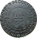
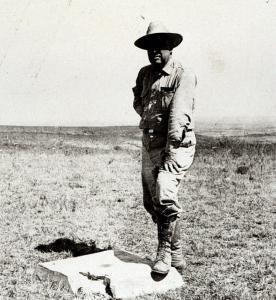
In order to create a geodetic datum, surveyors undertook a mammoth collection of monument locations in the late 1800s. Surveyors installed brass or aluminum disks at each reference location. Surveyors connected each monument location using mathematical techniques like triangulation.
From the unified network of survey monuments, the result of triangulation was the North American Datum of 1927 (NAD 27). After, geodesists developed the more accurate NAD 83, which we still use today. NAD 27 and NAD 83 provide a frame of reference for latitude and longitude locations on Earth.
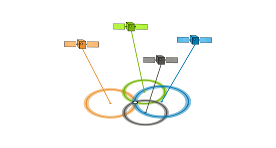
Surveyors now rely almost exclusively on the Global Positioning System (GPS) to identify locations on the Earth and incorporate them into existing geodetic datums. For example, NAD27, NAD83, and WGS84 are the most common geodetic datums in North America.
1. North American Datum 1927 (NAD27)?
NAD27 stands for the North American Datum of 1927. NAD27 is the adjustment of long-baseline surveys. Overall, it established a network of standardized horizontal positions in North America. Most historical USGS topographic maps and projects by the US Army Corps of Engineers used NAD27 as a reference system.
A horizontal datum provides a frame of reference as a basis for placing specific locations at specific points on the spheroid. Geodesists use a horizontal datum as the model to translate a spheroid/ellipsoid into locations on Earth with latitude and longitude lines.
Geodetic datums form the basis of coordinates of all horizontal positions on Earth. We reference all coordinates on Earth to a horizontal datum. The North American Datum of 1927 (NAD27) is one of the main three geodetic datums in North America.
Meade’s Ranch
NAD27 uses all horizontal geodetic surveys collected at this time using a least-square adjustment. This datum uses the Clarke Ellipsoid of 1866 with a fixed latitude and longitude at Meade’s Ranch, Kansas. (39°13’26.686″ north latitude, 98°32’30.506″ west longitude)
Surveyors chose Kansas as a common reference point because it was near the center of the contiguous United States. The latitudes and longitudes of every other point in North America were based on its direction, angle, and distance away from Meade’s Ranch. Surveyors could measure any point with a latitude and longitude away from this reference point based on the Clarke Ellipsoid of 1866.
Surveyors gathered approximately 26,000 stations in the United States and Canada. At each station, surveyors collected latitudes and longitude coordinates. NOAA’s National Geodetic Survey used these survey stations and triangulation to form the NAD27 datum.
As time went on, the number of stations also grew. For example, surveyors benchmarked approximately 250,000 stations. This set of horizontal positions formed the basis for the North American Datum of 1983 (NAD83). In 1983, surveyors eventually replaced the NAD27 with NAD83.
2. North American Datum 1983 (NAD83)?
The North American Datum of 1983 (NAD83) is the most current datum in North America. It provides latitude and longitude and some height information using the reference ellipsoid GRS80. Geodetic datums like the North American Datum 1983 (NAD83) form the basis of coordinates of all horizontal positions for Canada and the United States.
The North American Datum of 1983 (NAD 83) is a unified horizontal or geometric datum and successor to NAD27 providing a spatial reference for Canada and the United States.
NAD83 corrects some of the distortions from NAD27 over distance by using a more dense set of positions from terrestrial and Doppler satellite data. NAD83 is a geocentric datum (referenced to the center of Earth’s mass) offset by about 2 meters. Even today, geodesists are continually improving horizontal geodetic datums.
3. WGS84: Unifying a Global Ellipsoid Model with GPS
It wasn’t until the mainstream use of Global Positioning Systems (GPS) that we developed a unified global ellipsoid model. The radio waves transmitted by GPS satellites enable extremely precise Earth measurements across continents and oceans. Surveyors and geodesists created a global ellipsoid model because of the enhancement of computing capabilities and GPS technology.
This has led to the development of global ellipsoid models such as WGS72, GRS80, and WGS84 (current). The Global Positioning System (GPS) references the World Geodetic System (WGS84) as its coordinate reference system.
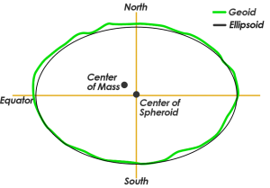
Never before have we been able to estimate the ellipsoid with such precision because of the global set of measurements provided by GPS. It consists of a reference ellipsoid, a standard coordinate system, altitude data, and a geoid. Similar to NAD 83, it uses the Earth’s center mass as the coordinate origin. Scientists believe the error is less than 2 centimeters to the center mass.
What is EPSG4326? Answer: EPSG4326 is just the way to identify WGS84 using EPSG. Here is the spatial reference list.
Geodetic Datums: NAD83 versus NAD27
NAD83 corrects some of the distortions from NAD27 over distance by using a more dense set of positions from terrestrial and Doppler satellite data. Geodesists developed the NAD83 datum using approximately 250,000 stations. This compares to only 26,000 used in the NAD27 datum.
One of the primary differences is that NAD83 uses an Earth-centered reference, rather than a fixed station in NAD27. Surveyors referenced al coordinates to Kansas Meade’s Ranch (39°13’26.686″ north latitude, 98°32’30.506″ west longitude) for the NAD27 datum.
The National Geodetic Survey relied heavily on the use of the Doppler satellite to locate the Earth’s center of mass. However, NAD83 is not geocentric with an offset of about two meters.
North American Datum of 1983 is based on the reference ellipsoid GRS80 which is physically larger than NAD27’s Clarke ellipsoid. The GRS80 reference ellipsoid has a semi-major axis of 6,378,137.0 meters and a semi-minor axis of 6,356,752.3 meters. This compares to the Clarke ellipsoid with a semi-major axis of 6,378,206.4 m and a semi-minor axis of 6,356,583.8 meters.
The Varying Historical Accuracy of the Ellipsoid
Is the Earth Round? Earth bulges out more at the equator than at the poles by about 70,000 feet.
And since the beginning of the 19th century, the dimensions of the ellipsoid have been calculated at least 20 different times with considerably different accuracy.
The early attempts at measuring the ellipsoid used small amounts of data and did not represent the true shape of the Earth. In 1880, the Clarke ellipsoid was adopted as a basis for its triangulation computations.
The first geodetic datum adopted for the United States was based on the Clarke ellipsoid with its starting point in Kansas known as Meades Ranch.
One Datum with Many Versions and Abbreviations
Since 1986, geodesists have made several updates to NAD83. Actually, because of these changes, there is more than one version of NAD83. For example, the National Geodetic Survey has adjusted the NAD83 datum four times since the original geodetic datum estimation in 1986.
| Datum | Description |
|---|---|
| NAD83 (1986) | This version was intended to be geocentric and used the GRS80 ellipsoid. |
| NAD83 (1991, HARN, HPGN) | High Accuracy Reference Network (HARN) and High Precision Geodetic Network reworked geodetic datums from 1986 to 1997. |
| NAD83 (CORS96) | Continually Operating Reference Stations (CORS) are composed of permanently operating Global Positioning System (GPS) receivers. |
| NAD83 (CSRS, CACS) | Canadian Spatial Reference System and Canadian Active Control System with GPS processing. |
| NAD83 (NSRS 2007, 2011) | National Spatial Reference System and current survey standard using multi-year adjusted locations based on GNSS from the CORS. |
The Importance of Datum Transformations

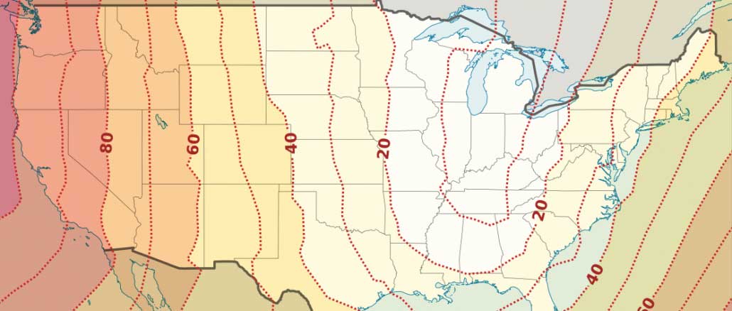
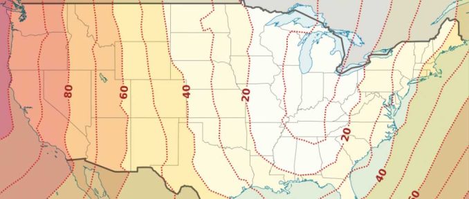
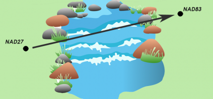
The coordinates for benchmark datum points are typically different between geodetic datums. For example, the latitude and longitude location in a NAD27 datum differs from that same benchmark in NAD83 or WGS84. This difference is known as a datum shift.
Depending on where you are in North America, NAD27 and NAD83 may differ in tens of meters for horizontal accuracy. The average correction between NAD27 and NAD83 is an average of 0.349″ northward and 1.822″ eastward.
It’s important to note that the physical location has not changed. To be clear, most monuments have not moved. Datum shifts happen because survey measurements improve. Also, it happens when there are more of them and methods of geodesy change. This results in more accurate geodetic datums over time. The horizontal datums that form the basis of coordinates of all horizontal positions in North America improve.
Because maps were created in different geodetic datums throughout history, datum transformations are often necessary. Especially, this is true when using historical data. For example, USGS topographic maps generally were published using a NAD27 datum. You would need to apply a datum transformation when working with NAD83 data.
When Do We Need Datum Transformations?
A coordinate transformation is a conversion from a non-projected coordinate system to a coordinate system. A coordinate transformation is done through a series of mathematical equations.
The geodetic datum is an integral part of projections. We reference all coordinates to a datum. A datum describes the shape of the Earth in mathematical terms. A datum defines the radius, inverse flattening, semi-major axis, and semi-minor axis for an ellipsoid. The North American datum of 1983 (NAD 83) is the United States horizontal or geometric datum. It provides latitude and longitude and some height information.
Unfortunately, NAD 83 is not the only datum you’ll encounter. Before the current datum, cartographers created maps using different starting points. And even today, people continue to change geodetic datums in an effort to make them more accurate. A common problem is when different coordinate locations are stored in different reference systems. When combining data from different users or eras, it is important to transform all information into common geodetic datums.
Projected coordinate systems are based on geographic coordinates, which are in turn referenced to a datum. For example, State Plane coordinate systems can either reference the NAD83 or NAD27 geodetic datums.
NAD27 Datum vs NAD83 Datum
The NAD27 datum was based on the Clarke Ellipsoid of 1866:
| Semi-major axis | 6,378,206.4 m |
| Semi-minor axis | 6,356,583.8 m |
| Inverse flattening | 294.98 |
The NAD83 datum was based on the Geodetic Reference System (GRS80) Ellipsoid:
| Semi-major axis | 6,378,137.0 m |
| Semi-minor axis | 6,356,752.3 m |
| Inverse flattening | 298.26 |
When you transform NAD83 and NAD27 geographic coordinates to projected State Plane coordinates, it is the same projection method. However, because the geodetic datums were different, the resulting projected coordinates will also be different. In this case, a datum transformation is necessary.
For any type of work where coordinates need to be consistent with each other, you must use the same geodetic datum. If you are marking property of land boundaries, building roads or planning for coastal inundation scenarios, you must know about and use the correct geodetic datums.
READ MORE: Datum Transformations – Converting Coordinates from NAD27 to NAD83
References
Image credit: NADCON – North American Datum Conversion Utility


Okay.
How do I get GAIA OPTIONS:
decimal degrees
degrees, minutes, seconds
degrees, decimal minutes
UTM coordinates
OR
MGRS coordinates
From:
NAD27 coordinates? There is a free GAIA version, if you want to research any of this. Thanks. Phil
Clarke 1880 was never used in North America. Bessel 1841 was used before Clarke 1866 was adopted because it was based on observations of triangulation arcs of North America.
Cliff Mugnier
One of the most clear, concise, descriptions I have read. Well done.
The photo shown is a benchmark, not a triangulation station. Benchmarks refer to elevation only and not to geographic position.
1 no one cares unless autistic,
2 they’ve mostly all been monumented for coordinates as well now and are regularly used by surveyors for such when setting up RTK base.