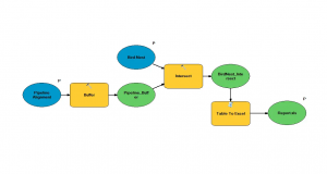
ArcGIS ModelBuilder: How to Create a Custom Toolbox
This example explains how to use model builder in ArcGIS. We show you how to create custom toolboxes and export models as Python scripts.
This example explains how to use model builder in ArcGIS. We show you how to create custom toolboxes and export models as Python scripts.
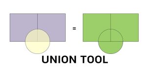
The Union tool combines input data layers into a single composite layer, preserving the boundaries and attributes from all input features.
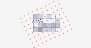
Bilinear interpolation (or bilinear resampling) uses 4 nearest neighbors to generate an output surface when you resample or reproject rasters.
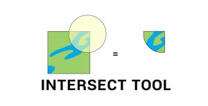
The Intersect Tool in GIS performs a geometric overlap. All features and attributes that overlap will become part of the output feature class.

Distance decay is the idea that the farther away customers are from goods or services, the less likely they will make use of it.
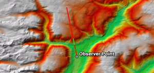
While line of sight determines obstructed and unobstructed on a line, a viewshed dictates surrounding areas as visible or non-visible from an observer POV.
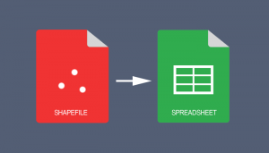
If you use ArcGIS 10.2 and above, you can use the “Table to Excel” tool to convert a shapefile table to Excel spreadsheet & export field aliases / subtypes

A geofence is a virtual geographic boundary. Whether it’s for security, retail or delivery, geofencing gives real-time alerts and increases awareness.
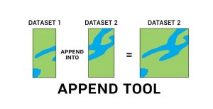
The Append Tool adds data from one or more sources of data and puts it into an existing target dataset, without creating a new dataset.
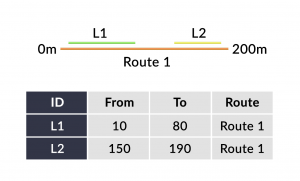
Linear referencing systems (LRS) store relative positions on an existing line feature with m-values for point/line events and linear analysis.