Union Tool in GIS
What is the Union Tool?
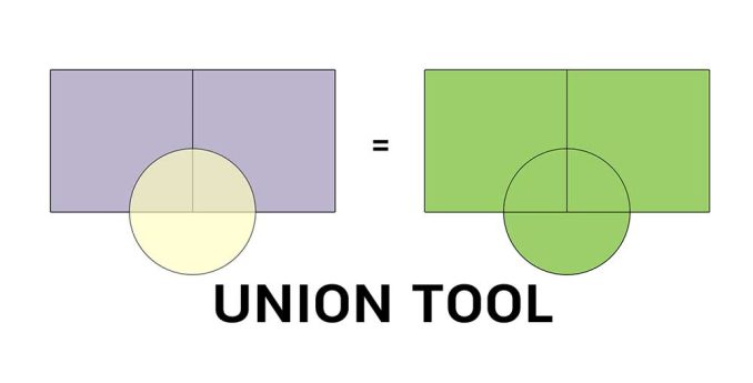
The Union tool combines input data layers into a single composite layer, preserving the boundaries and attributes from all input features.
When features overlap, it creates separate features for them. For non-overlapping parts, these also get passed into the output as well.
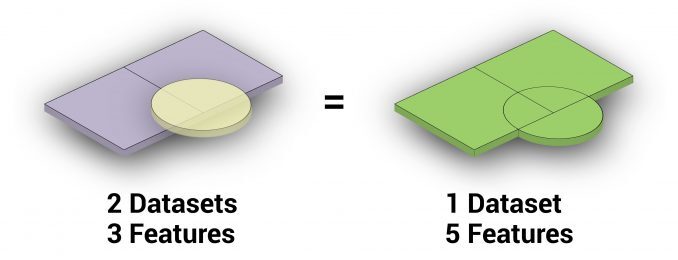
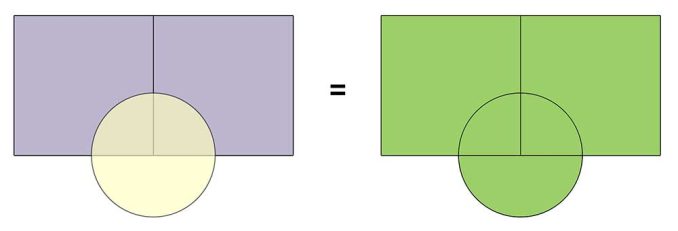
In this example, we have an overlapping circle and two squares. The circle is a single record and the square consists of two separate records.
In this case, the union produces 5 records in total. One feature is from the original circle and two are from the original squares. Finally, the two extra features are attributed to the overlapping portions.
What are some examples of using the Union Tool?
After running the Union Tool, it gets a bit messy. This is especially true because it generates a lot of features and overlaps in the output. For this reason, you have to be careful about how you use this tool.
In particular, you may have to do a lot of data cleanup with your output. For example, it may include using the Dissolve Tool or running topology checks. If the results are too much to handle, then likely you should have used a different geoprocessing tool.
But unioning does play an important role in geospatial analysis. Specifically, it has been especially useful in habitat suitability applications. It’s when you run this tool, you can understand where different habitat types overlap.
How to use Union in ArcGIS
This Overlay Tool is available in both ArcGIS and QGIS. In ArcGIS, you can find it in the Analysis Toolbox part of the Overlay Toolset.
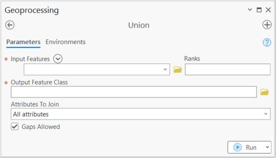
First, add your inputs that you want to run the Union Tool for. The other mandatory field is the name for the output feature class.
You will also have options for how you set the output attributes and whether or not gaps are allowed. You can also change how you rank the input features, which will order how output features are created.
How to use Union in QGIS
In QGIS 3, this tool is available in the Vector Menu | Geoprocessing Tools | Union.
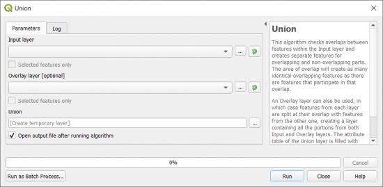
There are not many differences between the tools in these two GIS software packages, except for how you can add multiple inputs in ArcGIS.
QGIS only allows two layers for using the Union Tool. It can get a bit messy sometimes, so maybe this is a preferable option.

Summary: The Union Tool
The Union Tool spatially combines layers into a composite layer.
It sometimes gets a bad reputation because it creates a lot of features – so many that the tool should come with a bottle of antacids.
As long as you use this tool with caution, then you can accomplish the results you need.
Do you use the Union Tool? How do you use it? Please let us know with a comment below.


