10 GIS Career Tips to Help Find a GIS Job

GIS Career Tips Anyone Can Benefit From
You’ve always loved geography.
And you’ve always loved technology.
This is why you’ve pursued a GIS career path.
But if you’re having trouble getting your foot in the door for a GIS job, we have a list of 10 GIS career tips that anyone can learn to do.
Let’s do this:
1. You’re More Than Just a “GIS Technician”
Nowadays, almost every industry is finding new ways to use GIS. Literally, there are thousands of GIS applications in use today. GIS is highly dispersed across sectors within the workforce. For example, government, environmental, and natural resources industries rely on GIS for decision-making. When you can learn GIS, you can advance your career in this growing technological sector.

But there are also the less obvious industries like healthcare, archaeology, and GIS on the farm. These industries are screaming for GIS. Make the business case for GIS at your organization.
Because you really are more than a GIS technician. You tilt the odds in your favor by having expertise in complementary fields like data science.
You can think of GIS as more of a tool to complement forestry, web development, geology, etc. A varied skill set serves you well. Adapt to technology and software change. Don’t ever stop training and don’t ever stop looking for a challenge. What are some of the other popular trending GIS jobs?
DATA SCIENCE: Data science has seen +650% job growth since 2012 (source: LinkedIn) and is estimated to grow by 11.5 million new jobs related to data science by 2026 (source: U.S. Bureau of Labor Statistics).
PROGRAMMING: The U.S. Bureau of Labor Statistics (BLS) projects a 21% growth in employment for software developers from 2018 to 2028. Start learning software development with these GIS programming tutorials. But be careful about listing Python experience on your resume if you don’t want a programming job.
WEB MAP DEVELOPMENT: Web map development is a skill high in demand with JavaScript leading the way as the most popular programming language in web development.
2. Rewrite Your CV/Resume
Most GIS applicants follow 3 steps when applying for a GIS job:
- First, they write their experience and skills in their resume.
- Second, they find a GIS job posting.
- Finally, they send that same resume to the employer and pray for a callback.
But this strategy will only get you screened out because you’re missing the key qualifications. In order to get an interview, you have to tailor your resume (CV) to job postings. For GIS analysts, programmers, cartographer jobs, and any career, this is how to stand out from the crowd.

Here’s what you can do:
- After thoroughly reading a GIS job posting, highlight the required and desired qualifications.
- Next, list your relevant education, volunteer, and work experience, and skills YOU bring to the company.
- Finally, rewrite your CV using the job description as a template and by matching your skills.
If something is important enough to be listed as a desired qualification, it is important enough to include it in your resume. If you rewrite your resume using the job posting as a template, you significantly stack the deck in your favor.
On average, 20% of job applicants get an interview. But this also means that 80% are left empty-handed for a GIS job interview. Don’t get screened out by thoroughly matching your skills to the job qualifications.
If you’re having difficulties re-writing your CV/resume to cater to the needs of each job posting, remember that there are tools like ChatGPT that can help you.
3. Explore Every Opportunity
You will most likely start your GIS career in an entry-level position. To be clear, GIS entry-level jobs are part-time often targeted at recent graduates, and do not include employee benefits.
On the other hand, GIS internships are opportunities offered to potential employees to work for a fixed or limited period of time. These GIS jobs give you mind-numbingly boring tasks. Also, they aren’t good at paying the bills.
But when it’s all said and done, you really just need the opportunity to get your foot in the door. Regardless of your experience, you can test out different opportunities without commitment.
When you’re first starting, apply for everything because getting a GIS job is not easy. But what should you do if there aren’t any GIS entry-level jobs or GIS internships available?
There is a tremendous amount of GIS volunteer opportunities available. Although GIS volunteers freely offer their services, they get something valuable in return. Of course, this is an on-the-job work experience.
For example, here are two popular GIS volunteering organizations:
- GIS CORPS: GIS Corps is one way to tap into GIS volunteering. These volunteering opportunities could be anything from community development to improving health and education for underprivileged communities worldwide.
- URISA: Urban and Regional Information Systems Association (URISA) coordinates short-term, volunteer GIS services for humanitarian relief. Not only are you doing something good for the community, but you are also beefing up your GIS resume. All things considered, it’s a win-win situation for you.
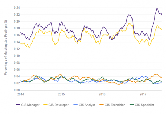
In terms of GIS job trends, GIS developers and managers account for the highest percentage of job postings (Indeed, 2018). But in terms of job duties, GIS technicians, specialists, and analysts are similar. If you summed up their number of job postings, it would be close to the level of managers and developers.
4. Plan Your Career in GIS When You’re in School
It’s never too early to plan for your future GIS career. If you think, live, and breathe GIS, integrate GIS into class projects. This is how to build experience for your future in GIS. Nothing makes a candidate stand out more than having a portfolio of work.

Pad your resume with these skills. Of course, this doesn’t mean you should lie. But it shows you’re eager to learn GIS on your own because employers want to see that.
While you’re at it, create a portfolio of maps. Highlight the best-looking maps and projects for interviews. Be prepared to talk about them. Not only does this show your mapping capability, but it also shows that you’re organized and can work independently.
Do you have a working website for your mapping portfolio? Even better. According to Workfolio, 56% of hiring managers are more impressed by a candidate’s personal website than any other personal branding tool. But only 7% of job seekers actually have a personal website. This is why GIS job seekers should have their own personal portfolio to be distinct and ultimately stand out.
5. Practice Makes Perfect Before the Interview
If you’re rusty in GIS, study up before the interview. Even if you’re not rusty, expect the unexpected for technical questions.
Interviewers will hammer you with technical questions on projections, tools, and databases. Don’t get caught off guard. It’s best to prepare yourself for an onslaught of GIS questions and do some interview prep beforehand.
When you land your dream GIS job, things don’t get much easier. You have to understand GIS inside-out because it’s about thinking critically and solving problems.
At your GIS job, you constantly deconstruct problems and solve them. There’s more than a single way to solve a problem. And more than likely others have solved the problem already.
In your GIS career, Google is your friend. If you hit a roadblock, see how others approach the same problem. Showing you have personal initiative and drive to problem-solve speaks miles.
PRO TIP: Keep up with GIS programming and scripting, specifically Python. This one skill is high in demand and can help you get a GIS job much faster.
6. Be Honest About Your Expected Salary
Here’s a scenario you may be familiar with: You apply for a GIS job you want. Then, you land an interview. But they hit you with the unexpected: “What are your salary expectations for this GIS job?”
Employers ask this question because they can filter candidates with too high expectations. Two unwanted things can happen when you give your GIS job salary expectation:
1. If you answer too high, you can cut yourself from the competition.
2. If you answer too low and undervalue your work potential, you might leave money on the table for the GIS job.
But the best thing is to be honest about your expected salary. So, how do you answer the GIS salary question during interviews? Here are some options to not get tongue-tied:
- Don’t get caught off-guard. Prepare your salary expectations beforehand
- Don’t list a salary range, if you’d be unhappy taking the lowest end of it.
- Research comparable GIS salaries. The labor market sets the price.
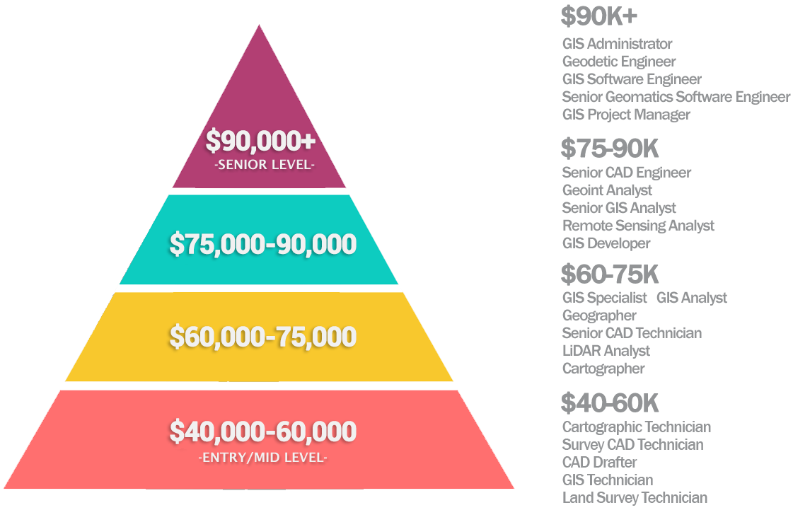
We’ve also scoped out the GIS job salary ranges for analysts, developers, and technicians. Overall, GIS jobs pay anywhere from $40,000 (GIS technicians) to over $100,000 (software engineers). Climb the GIS career ladder and move up the pay scale.
According to the US Bureau of Labor Statistics (BLS), geographers earn an average of $88,900 annually with a 1% job growth outlook. But cartographers and photogrammetrists earn an average of $71,890 per year with a job outlook to grow 3% from 2020 to 2030. This is faster than the average rate of growth.
7. Join Your Local GIS User Group
User groups are the lifeblood of any GIS community. For whatever reason, GIS user groups are usually very active. They’re YOUR community and YOUR chance to really build relationships with your peers.
According to the Federal Reserve Bank of New York, personal referrals from friends who work for employers with job openings are the #1 way to get hired today.
This means that as bad as it sounds: It’s not what you know, it’s who you know. So, the question is, how can you rub shoulders with GIS influencers near you?
One tip is to join your state, provincial, or local GIS user group. Even though some communities are tight-knit, they sometimes offer student opportunities at conferences like scholarships or volunteer presentations. Involvement in a GIS community such as on GIS day and Esri User Conferences goes a long way.
Network or volunteer some time at your local URISA chapter. Explore what projects people are working on in the GIS community. This is a good starting point for getting to know GIS consultants and influencers near you.
8. Relocate To Where GIS Jobs Are
The truth is that sometimes jobs simply don’t come your way. That means for some of us, there’s never been a better time to trailblaze to your next GIS job opportunity. Because we all know there aren’t a lot of GIS jobs where you can work from home. Less so nowadays though. And few people are willing to relocate.
The GIS job market is imbalanced with gaps that need filling. Some states and provinces are in surplus while others are at a loss. So the question is: If you had a job offer in another city, would you take it?
Although relocating will increase your odds of finding a job, it’s not for everyone. It may be a good decision for someone early in their GIS career. On the flip side, someone with 10-20 years of GIS experience may have more ties to their city.
By sheer number, California and Texas are the most widespread with GIS career opportunities. As a whole, The U.S. Bureau of Labor Statistics expects geography positions to grow by 1% by 2030. So, all you might have to do is hang on tight to be hired in a GIS job.
9. Consider GIS Certification
What four-letter acronym demonstrates your education, professional experience, and contributions to the profession of GIS? _ _ _ _
The big four-letter acronym is GISP (Geographic Information Systems Professional). And there are companies out there that look for those four letters after your name.
You better believe it. GIS certification might just give you an edge over other candidates. After they filter out hundreds of candidates, that GIS certification might be the tie-breaker you need.
But remember that GISP isn’t the only GIS certification game in town. In fact, Esri certification has been breaking a lot of ground. After all, it’s Esri software that is most used in workplaces, universities, and colleges.
Showing employers that you’re proficient in ArcGIS with an Esri certificate guarantees they are hiring someone with an advanced skill set. And let’s not forget all the free Esri training available to help you become proficient in your field of study.
There are online GIS certification options too from recognized universities. Because if you want to grow personally and professionally, you can’t just go with the flow. Instead, you need a direction to go in. So, GIS certification might just be the direction you need to go in.
READ MORE: GIS Certification: Is It Worth It?
10. Know the GIS Job Boards and Find Your GIS career
Scan the job boards and try to apply as soon as possible when new GIS jobs open. What are the boards with GIS job listings?
Because GIS is so diverse, there are so many career paths you can take. For example, you can work in cartography, programming, remote sensing, and even data science. Or maybe GIS freelancing?
Don’t limit your job search keywords to just “GIS”. Instead, try to think outside the box. Here’s a list of GIS job search terms that usually go hand-in-hand.
Bonus: Try Thinking Outside the Box
Because GIS is an emerging field, some companies don’t know where or how to use it. Here are some non-GIS jobs where it still has some room to grow:
FIELD WORK: Heavy construction, forestry, environment, archaeology, and mining are industries begging for GIS. For example, you can set up GPS mobile apps in QField or ArcGIS Collector for any type of work. For example, they collect information on invasive species, endangered animals, and site excavations. Best of all, you get a mix of desk work and site visits.
SURVEYING: Surveyors go to construction to update legal boundary lines. No two days are the same for surveyors. Precise locations are taken for site exploration, land subdivisions, and civil engineering projects.
HIGH-LEVEL RESEARCH: As part of a GIS Master’s degree or Ph.D. program, you can get funded for high-level research. For example, you can write a research grant for a GIS-related hypothesis. Your university could point you in the right direction, test your hypothesis, and publish a paper.
DRONE PILOT: When Amazon conceptualized its mail-delivery drone, the GIS industry’s eyes lit up. Drones gather data from the sky in fields like agriculture, search & rescue, and the environment. Even realtors use drones to advertise open houses.
MILITARY OPERATIONS: The military is one of the biggest users of remote sensing and location intelligence. Ever since the Corona spy satellite, there’s been a growing demand for reconnaissance. But overseas deployment may not be in the cards for your life chapter.
Let’s Break It Down for You
Geographic Information Systems might just be the most “booming” career in terms of geography degrees.
If you’re studying geography, you need the right GIS career information.
Hopefully, these time-saving ideas help you pave the way to a bright future career in GIS.
Follow these 10 steps in this GIS career guide and instantly boost your chances of success.
Now, it’s your turn. What are some ways to help your chances of getting a GIS career?
Please let us know with a comment below.


Thank you for these wonderful tips, it’s really helpful.
Happy to help out!
Thank you very much for guiding us. Valuable information.
Thank you very much for guiding us..
I have a Bachelor’s degree in Environmental Science and currently, I am a technician for a massive corporate company. I hate my commute, work-life balance sucks, and I wish to work remotely. I think GIS is an option for me, but I’m not really sure how to get there. My ideas are to get as many relevant certifications as possible, (Python, Esri, GIS, etc.) and hopefully land a remote position that pays at least 25 dollars an hour. I am also a Mom, so the job needs to be stable with benefits. Is this possible, or am I dreaming? If it’s possible, how do you recommend that I get there?
Yes, I personally think it is possible. Remote work is quite common now (or at least a hybrid of remote working) and I believe will continue after the pandemic. There are some companies who switching to long-term remote work, which can at least save them from the cost of having office space. Last I heard, this includes major companies like Microsoft, Apple, Verizon, and Adobe.
Thanks for the practical tips to help me get into the field of GIS. I agree to explore every opportunity as fields like data science and machine learning go hand-in-hand with it.
I want to know that age limit of the government job in Geographic Information Systems. Thank you.
Can you explain how marrying soil science with GIS would make someone unstoppable? Thanks!
Hi. I’m 53 yo and changing careers–I’ve been a pilot/flight instructor, but am (slowly) working towards a degree in Marine Biology. I’m interested in adding a GIS certificate, specifically to use the mapping features for the Biology field. Currently, I’m taking “R” online, but am wondering if Python is something necessary for GIS work? And would taking some CAD courses supplement GIS work in general? Lastly, would having a drone certification blend with GIS work? Thanks!
Hi Diana
These are all great questions and I’ll do my best to answer them.
1. Is Python necessary? No. There’s a lot of GIS professionals who can’t write a line of code in Python. With that said, it would certainly help get a job in GIS. Python is at the top of the list for coding languages so it sounds like you’re on the right track for programming language priorities.
2. Does CAD supplement GIS? I don’t think it would supplement GIS. From my experience, most of the work I’ve done with biologists involve your basic field collection. Perhaps with ArcGIS Collector or Survey123. The observations biologists collect often are QC’d and then published in a Geographic Information System. So I haven’t seen too much CAD coupled with biology. But perhaps someone else might chime in the comments section.
3. Drones and GIS are an up-and-coming field. And it really depends on the company you work at if they will utilize them. For example, agriculture may use a drone to collect near-infrared and calculate NDVI. Farmers can use this data to better understand crop productivity.
Overall, I think all of these skills will help you out. Best of luck!
I am a System Admin, but realized GIS is a crosscutting tool. Having helped set up few GIS systems, I now want to switch career into Data Visualization, focusing on GIS and Remote Sensing. What career path will you advice?
I read the comments, and I am like “wow!” I have worked with GIS for several years, and yeah some days it can be stressful. Some days can be laid back. All in how you do your work. Are there career opportunities out there? You bet! As time goes on there are more and more people getting into GIS, so the market will change. That’s the way it is with every career out there. I compare it to a reversed version of consumer economics- You have a demand, so you create a supply. You get over stocked, prices go down and merchandise goes to the clearance shelves.
I suggest to everyone, get a GIS certification before anything else, and get a degree. Name a degree and I betcha there is a need for GIS in that industry. Who are you gonna hire? A wildlife biologist fresh out of college or a geologist fresh out of college that has a GIS certification and a few years of GIS experience? Now you just changed the playing field. Right now, out of 100 applicants to an entry level position, your GIS cert is gonna kick 70-85 of them right out of the game. Now it’s you versus 14 other applicants. Ok, maybe my numbers are off some, but it’s still true.
I feel sorry for JP, he didn’t use common sense. Cameron, a nurse with a GIS cert? WHO, UNICEF, Doctors Without Borders, just a few potential employers. You’re a nurse, so you know how to take care of yourself.
Just remember- GIS is a tool. Use it accordingly.
I am a Gulf War veteran and worked as a cartographer/terrain analyst while serving in the Marine Corps from 1986-1992. I also have about 46 credit hours and a cert in ACAD. I am very interested in getting back into the field of cartography or GIS. Any advice on how to get there?
Thank you so much! I appreciate all your help. I will definitely come here for GIS questions, if you don’t mind :)
I have graduate coursework in archaeology and lots of experience in field work in cultural resource management. I’ve had introductory course work in ArcGIS, and have used it a little bit in the field.
I’d really like to do more imagery, mapping (I’ve done a lot of field mapping and am really good at it), and analysis. I know the archaeological field can be tight, but could I also get a job in related fields or even unrelated jobs?
I love GIS and am very project oriented and need to know if it’s worth spending money on courses or certificates. I wouldn’t mind just going for a degree in Geology/Geography, I love being in school, but I have degrees already and I really would like to have a career now.
Thanks for any help you can give me
Hi Cori, this is a great idea. It would be interesting to find demand in the various GIS related fields. I’ll see if I can get this information and make a post of it. It probably would take some time, but appreciate the great suggestion
I am currently doing diploma course in programming and GIS and have a bachelors degree in geology. Will I be able to get an entry level GIS job in India?
Hi Nishad – Not too sure as every situation is different. If you’re willing to relocate, I couldn’t imagine not seeing a GIS job in geology. Especially, your programming background will help you a lot.
I am fresh graduate majoring in anthropology, but realized there is no jobs available, and now switching careeer in GIS. Would it be an easy change as I have no background in programming?
I think GIS and anthropology are dissimilar. It’ll take a bit of effort to familiarize but it’s possible. Although you don’t necessarily need a programming background, it certainly helps.
Thanks for this piece of information. But how can I have full access to penn state open course ware? Asking Username and Password for their Canvas, which contained detailed materials needed
GIS with urban planning, could this be a good combo for the future? I have a bachelor (5 years work experience) in urban planning and I expect to gain my master in GIS at the end of this year (I am 32 years old).
I think this is a great combo. The work experience definitely helps
When you click on the BLS link in the article, the website says there will be a -2% decline in jobs from 2014-2024. Can you explain where the 29% increase stated in the article came from?
It looks like the Bureau of Labor Statistics (BLS) revised their forecast (unfortunately) to a decline.
On the bright side, BLS has cartographer and photogrammetrists jobs at 29% growth here – https://www.bls.gov/ooh/architecture-and-engineering/cartographers-and-photogrammetrists.htm
The article has been updated, thanks for that
I’m currently looking at a career change into geography/GIS at 47. Any tips for an old nurse with a crappy back with absolutely no experience in geography?
Why GIS/geography? I need a career that will be 1. kind to my back 2. interesting 3. my daughter does it. 4. eh, why not?
Hi Cameron
To answer your four questions:
1. GIS practitioners often have desk jobs, but some of them are lucky to go out in the field as well. For those that are at their desk all day often can get back strain. However, standing-desks and short micro-walks can alleviate the pain. GIS practitioners rarely or don’t do any heavy-lifting so I’d say it will be kinder to your back.
2. Depending on your position, GIS can be an interesting one. Some professionals complain if they have redundant tasks such as digitizing all day. But you can even make that fun by trying to automate it with remote sensing and even out-of-the box tools like Esri’s mean segment shift. GIS is really growing with new tools and technology every day. I find GIS very interesting and that’s why I chose it as my career.
3. I personally think that geography is something that kids gravitate to. It’s good to know the world and your surroundings. I’ve been meaning to take my kids out with a telescope or some of the cool smart phone apps to see some of the orbiting satellites which monitor our Earth. Even geocaching with a GPS is fun, and kids get to learn directions and their environment.
4. Why not?
I think this may be a bit of tougher transition going from nurse to a GIS professional. It’s definitely a big time-commitment for studying and not an easy one when taking care of a child.
Despite reports saying use of drones, photogrammetry, LiDAR, computer programming (which all relates to GIS), depending on where you live jobs can be hard to come by. There also may be a lot of applicants for that position. All in all, some say that GIS is a hard field to get experience in for entry positions.
I believe that nursing is a high-demand career. Nurses are positions that children look up to, and that they can also learn from. If your back is a concern, there are ways to strengthen your back muscles and I’d take that as a first step. I often do this myself sitting at a desk all day.
…Overall, if money is a concern, I think that you should stay in your current employment. If you have extra time, test out a class or two for part-time. Perhaps, try the following to test the waters.
Esri’s Massive Online Open Courses: https://www.esri.com/training/mooc/
Penn University Open Courseware: https://onlinelearning.sas.upenn.edu/learning-opportunities/massive-open-online-courses-moocs
The problem is that GIS is only 1 tool that anyone who is already a professional with a job can learn. Your better off going to school for something else. GIS is not easy and very stressful. It is 9 out of 10 for the most stress. You will be stuck at a computer which is very unhealthy and are the first to be cut at a company. Get a job that is something that you really want to do and is available. Don’t bother going to college or spending all of this money on certifications. It is not worth it. I know as I have been in it for 18 years now. It gave me the worst life for myself and my family. No opportunities or very rare ones. The colleges should stop teaching it as there are way too many people that have been promised a great career and are now living on welfare or are retrained in another area. Trust me on this because I would hate to see another person screw up their life by going into this field.
Payscale and CNN give the following ratings to GIS specialists as a job:
Quality of life ratings:
Personal satisfaction: C
Benefit to society: B
Flexibility: B
Low stress: A
So every situation is different.
Thank You for posting this it was really helpful.
Thanks for this very useful information. I will study hard for my intern interview on tuesday. (Twitter)