Oklahoma Lakes and Rivers Map
About the map
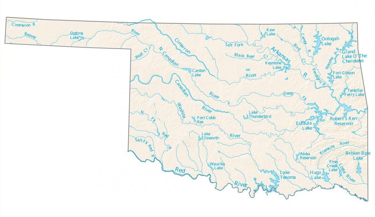
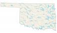
This map shows the major rivers, reservoirs, and lakes of Oklahoma. In general, rivers in Oklahoma flow south. The largest lakes in Oklahoma are Lake Texoma, Eufaula Lake, and Grand Lake O’the Cherokees.
In terms of surface area, Eufaula Lake occupies over 41,000 hectares in three different counties. But Broken Bow Lake is one of the deepest and most scenic in the southeast corner of the state.
One of the major rivers in Oklahoma is the Red River, which is part of the second-largest river basin in the southern Great Plains. In fact, it’s the river that divides its southern border with Texas.
Oklahoma map collection
You are free to use our lakes and rivers map of Oklahoma for educational and commercial uses. Attribution is required. How to attribute?
Oklahoma lakes, rivers and reservoirs
Lakes and reservoirs
Lake Texoma
Eufaula Lake
Robert S Kerr Reservoir
Oologah Lake
Lake O’ The Cherokees
Hugo Lake
Broken Bow Lake
Optima Lake
Canton Lake
Keystone Lake
Kaw Lake
Fort Gibson Lake
Tenkiller Ferry Lake
Lake Thunderbird
Atoka Reservoir
Fort Cobb Reservoir
Lake Ellsworth
Waurika Lake
Rivers and streams
Cimarron River
Canadian River
Washita River
Red River
Arkansas River
Little River
Verdigris River
Wolf Creek
Beaver River
Black Bear Creek
Caney River
Bird Creek
Neosho River
Kiamichi River
Pine Creek
Do you by chance have an .svg copy of the lakes and rivers map? I am working on helping my daughter with a project for school also, and the .svg will work better for the size I’m trying to do.
Thank you!
Sorry, but no we don’t
My son is doing a 4-H project about the kinds of fish in the lakes of Oklahoma. Can you email a map with the lakes and their names please? I can not get it to print correctly at home! Thank you!
Done, I sent it by email
Can you leave highlights of what rivers like the Cimmaron River start in Oklahoma, and then leave it a state, and then come back.
Thank you.
Is there a higher resolution version of the Oklahoma River Map? I am working on paddling each of the rivers in the state and would like to create a large banner to hang up.
Ya sure, I can send that to you. Just send me your email address and I’ll get back to you.