What is Tobler’s First Law of Geography?
Tobler’s First Law of Geography states that everything is related to everything else, but near things are more related than distant things.

Tobler’s First Law of Geography states that everything is related to everything else, but near things are more related than distant things.
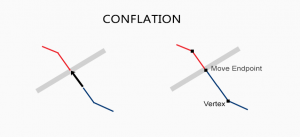
When you have two conflicting data sets, conflation resolves conflicts by preserving the most accurate one. Edgematching and rubbersheeting helps fix errors
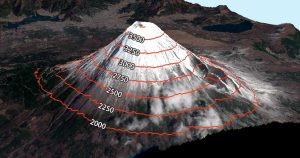
Contour lines have constant values on them such as elevation. But it’s also used in meteorology (isopleth), magnetism (isogon) & even drive-time (isochrones)
Huff Gravity Model uses store size and distance along with census tract population to understand the probability that consumers will patron retail stores.

When you take a photo with your GPS on, it stores its physical location where the photo was taken. Geotagging assigns coordinates to photos.
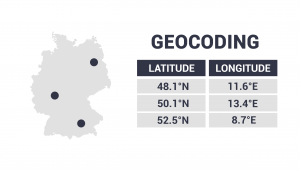
Geocoding takes an address, then translates it to a location on a map. It changes an address to lat long coordinates (latitude and longitude).

Spatial regression is used to model spatial relationships. Regression models investigate what variables explain their location.
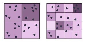
The modifiable areal unit problem (MAUP) is a statistical bias that occurs when you aggregate point data such as the scale and zonal effect.

This guide shows how Mean Absolute Error in GIS is used. We give a step-by-step instructions how to calculate MAE in Excel and a quick formula to use.
Principal component analysis PCA identifies duplicate data over several datasets & aggregates essential information into groups called principal components.