Top 6 Free LiDAR Data Sources
How to download free LiDAR data online
Does it feel like a big challenge to find LiDAR data sources?
How about free LiDAR data sources?
We understand. LiDAR is a beast of a dataset to work with. What other GIS formats have their OWN compression format (LAZ)? C’mon! Have you ever seen a shapefile with its OWN compression format?
This fact alone makes LiDAR repositories national treasures in GIS.
So, as Dr. Evil would say *pinky in the mouth* – BRING OUT THE LASER

(Laser for LiDAR, of course). We’re bringing out the lasers in this special post on 6 free LiDAR data sources.
1. USGS Earth Explorer
Previously, users could access USGS LiDAR data through CLICK (Center for LiDAR Information Coordination and Knowledge). However, this service is now being provided by the USGS Earth Explorer.
So you want USGS Earth Explorer LiDAR data? If you’re new to this platform, we have a quick guide to downloading data on the USGS Earth Explorer.
For LiDAR, it’s a simple process:
First, enter your search criteria (KML, coordinates, etc.). Next, select the checkbox for LiDAR in the data sets tab. Finally, click the results tab to see what LiDAR datasets are available.
- Search for LiDAR data with a user-friendly state-of-the-art interface.
- Filter searches by time and set regions of interest in a map by predefined areas and coordinates.
Also, USGS Earth Explorer sits on top of our 15 free satellite data sources, so it’s definitely worth your time to know it inside out.
2. NOAA Digital Coast
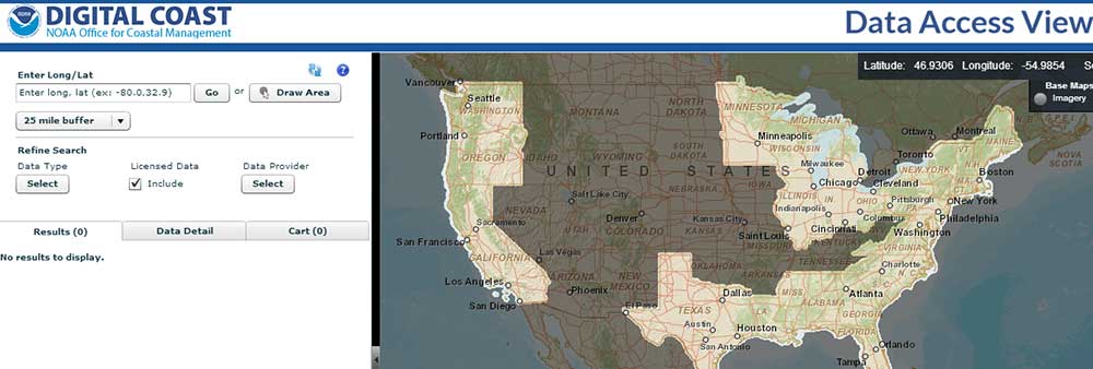
Surfs up. NOAA’s mission (in the sense of LiDAR data) is clear. Overall, they want to capture coastal area LiDAR data. Then, they serve this data openly to the public.
NOAA’s Digital Coast web map gives you the ability to know exactly where coastal LiDAR is located in the United States. This makes your search for coastal LiDAR data a no-brainer. Go with NOAA.
- Slick web application to search, analyze, and download free LiDAR data.
- Draw the area of interest and click LiDAR data download.
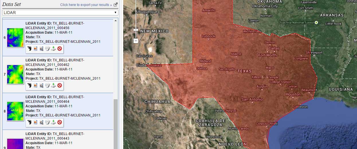
3. The United States Inter-agency Elevation Inventory
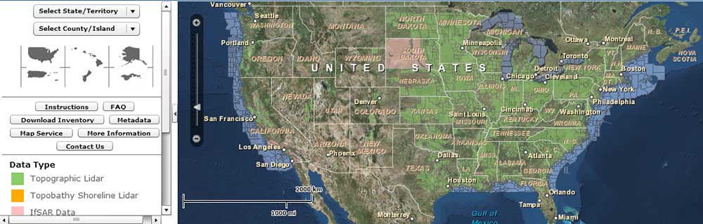
A Wikipedia of LiDAR? That’s right. There’s been a movement in the United States for a National LiDAR Dataset. This initiative is being led by the United States Inter-agency Elevation Inventory (USIEI). NOAA and USGS are spearheading this collaborative effort.
Several states have already moved forward in their own collections. To see exactly which states they are, the USIEI Inventory gives you this information along with vertical accuracy, point spacing, and date of collection. Downloading the physical data is not so straightforward. The National LiDAR Dataset Wikipedia page maintains download source locations.
- LiDAR sources are decentralized with partial and incomplete data across the United States.
- USIEI LiDAR data viewer displays the nationwide listing of known high-accuracy topographic data.
4. National Ecological Observatory Network (NEON)
One of the cool things about the National Ecological Observatory Network (NEON) is that they are funded by the National Science Foundation. Another neat thing about NEON is the amazing work they are doing with airborne LiDAR to map out vegetation stands.
All you have to do is go to the NEON Open Data Portal and type in LiDAR in the search field. You’ll get a range of LiDAR products with dates to select from.
Although some of NEON’s data may not have sufficient QA/QC to meet the end user’s needs, we still think NEON’s airborne LiDAR data has some serious potential.
- A minimal selection of LiDAR because in the construction phase.
- Beginning of a collection of publicly available LiDAR.
- Airborne, aquatic and terrestrial LiDAR instruments are available.
5. Equator Studios
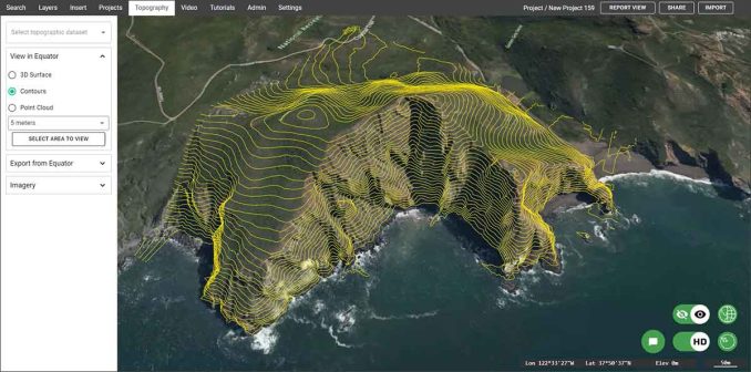
Looking for a shortcut? Try out Equator to find and download high-quality LiDAR data. It’s an online mapping platform that allows you to source public point cloud data.
So, Equator helps you obtain the data, to the best available accuracy. You can export what’s available as a LAZ file, and able to filter ground points, or just contours.
- View point clouds as classification, cross-sections, hillshades, etc.
- Convert LiDAR data to CAD and other formats for analysis
6. OpenTopography
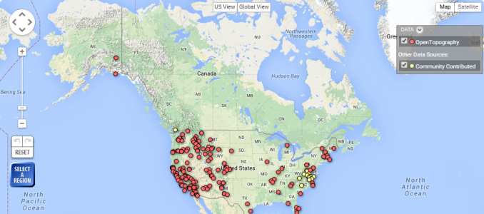
Free no more. Well, only if you have EDU email or teach K-12. That’s OpenTopography is now a subscription-based platform. Yikes. Only by using OT+, you can gain access to their LiDAR platform. That’s why we’ve dropped it like a rock on our list all the way down to #5.
Either way. You should take a peek if you don’t know about OpenTopography. The beauty behind OpenTopography is its open community system. When users register, they can upload their data so that the larger community can access it.
- Subscription-based access to topographic data.
- Request an API key with a user name and password.
- An intuitive web map displays LiDAR points as downloadable data with metadata.
Not a fan of the direction OpenTopography is taking.
Summary: LiDAR Data Sources
Before reading this article, you probably thought free LiDAR data was hard to come by.
Now, you know it’s not so bad.
We’ve provided you with 6 different LiDAR data source options.
Did we miss any? Please let us know in the comment section below.
Changelog
2024/07/11 – OpenTopography moves down to #5 because it’s now a “subscription-based” platform (not free)
2025/08/03 – Added Equator as a platform for viewing and downloading LiDAR data


Is there LIDAR of Indonesia? Does anyone have any info on this?
Has anyone here heard of ‘The Rest of The World? There are rumours of huge areas of land lying beyond the horizon…..Who knows, there may be intelligent life out there?
Lidar Map Archaeology and Landscapes:
https://www.facebook.com/LidarMapArchaeologyandLandscapes
Most lidar map websites are dreadful rabbit warrens designed by bureaucrats and no average person can find a simple-obvious, easy to use lidar map without having to click through 10 different levels of this or that -and you have to clairvoyantly know what all the gobbledygook code language labels mean in order to just find the damn thing. I say, gather up all lidar data from the whole country, take it away from all the governments and university types who are in love with bells and whistles and complexity and arcane obscurity, and give it all to eBay. They’ll have it mindlessly simple and easy to use, straightforward, and best of well-advertised so that millions will see it and use it, and they’ll have it up and running in 2 weeks.
I both thoroughly enjoyed and appreciated this comment, as I’m sure many of us “simple-minded” individuals have. And to start charging a damn subscription unless you have a .edu is horse-sh*t. I call foul, sir. but sadly enough that’s the world nowadays, all for profit greed.
I want to download 1m DEM for a study area outside USA
I need a LiDAR project out sourcing
Any LIDAR data on AIR QUALITY???
Hello. Thank you for your valuable information. Is this data available for the north of Iran? if yes, so please kindly guide how can be downloaded.
Is there free LiDAR data for DRC (Democratic Republic of the Congo)?
Thank you for these data, I need a lidar image for Haiti with high resolution
That big dish on the Death Star. Is that LiDAR?
They call it the “Concave Dish Composite Beam Superlaser”. Not LiDAR :)
Is there a site for free lidar data from Africa?
Is there LiDAR data avalaible for Africa?
Could Lidar ever be used to find tunnels and caves? If so, what world process be the maximum penetrating depth to reach the upper most part of the cavity?
The entire province of New Brunswick in eastern Canada has full, open, unrestricted use of lidar point cloud at 6 points / meter.
http://www.snb.ca/geonb1/e/index-E.asp
Is there LIDAR of Russia? Does anyone have any info on this?
Is there any free single-photon-lidar data? Required for research purpose.
Is there any free LIDAR data free for West Africa specifically Ghana?
Is there any free lidar data available for India? required for research purpose.
I need: LiDAR data captured by airborne or UAV platform. The required data should contain 4-5 consecutive swaths having specified overlap on an undulated terrain. Also, data captured for a man made or artificial or simulated terrain site (like stadium, university campus) are also okay.
Would a Lidar map of Romania be available ?
Check out Oregon Lidar Data Viewer. https://gis.dogami.oregon.gov/maps/lidarviewer/
Free raster lidar and vector data. Accessible on mobile devices! 3ft rasters compiles from high density lidar point cloud
Hi,
I need aerial photos for the digital photogrammetry application with the ground control points, exterior orientation, camera calibration and all other parameters needed.
Anyone have any ideas regarding multi temporal lidar data of the same place for landslide analysis?
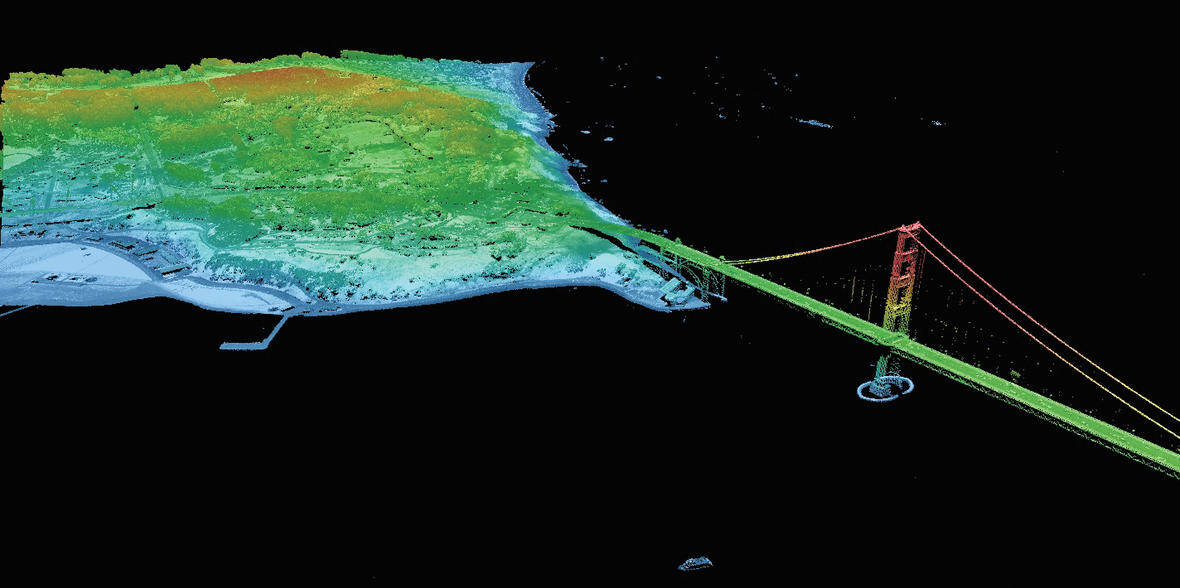
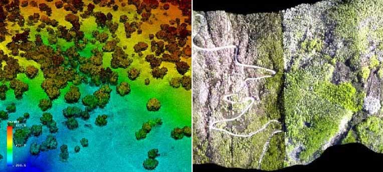
So I am very familiar with many of these sites…. but where did that Golden Gate Bridge Lidar come from? I have not come across that one (I have the one from NOAA but it does not have that resolution as pictured at the top of the page
I believe that its source is USGS
Does anyone knows a website where I can download free LiDAR data of the Philippines?
Let me know the availbility of LiDAR data for Java Island, Indonesia, especially in Yogyakarta
Is there any LiDAR data available for Romania?
Goescience Australia has free LiDAR data sets https://elevation.fsdf.org.au/
Does anyone know if there is any free LIDAR data available for Australia. I need to identify large farming properties in some of the states within the country.
Hello everyone,
On the websites below you find Lidar data from the Netherlands. Its called “Actueel Hoogtebestand Nederland”. It was collected during 3 periods.
AHN1: 1996 – 2003
AHN2: 2007 – 2012
AHN3: 2014 – 2019
The data is available in different resolutions and free downloadable.
AHN1: 100, 25 and 5 meter maaiveldraster (surfaceraster) and a “puntenwolk” pointcloud
AHN2 and 3 are available in 0.5 and 5 meter maaiveldraster (surfaceraster) and a pointcloud
AHN3:
https://www.arcgis.com/home/webmap/viewer.html?useExisting=1&layers=9039d4ec38ed444587c46f8689f0435e
Don’t forget The National Map for free elevation and Lidar data in the U.S. Right now, there is free, quality Lidar for specific regions, but in 8 years there should be Lidar data for the entire U.S. https://www.usgs.gov/programs/national-geospatial-program/national-map
Do you know of any LiDAR data sets for Mexico City? I searched through all these (I think!) but no luck. Free or for purchase, any recommendation is helpful. Thanks!
Does anyone know if there is any free LIDAR data available for Kenya or Tanzania?
I searched on those 6 websites and couldn’t find anything, unfortunately.
I’ve actually had luck in the past reaching out to local government, not-for-profit agencies, etc. If you can explain the purpose of your project, some groups are very willing to share – as long as you sign some sort of an agreement. You might be surprised.
Good luck in your search. Sorry I couldn’t be much help
If you have any high rise building las files and corresponding image, please share.
The lidar module in global mapper is very interesting
Hi Everyone,
Just found this site on google searching. Anyone out there from Eastern Canada, specifically northern New Brunswick, Canada. Interested in locating mineralized fault zones or buried massive sulphides, any pointers on locating lidar maps dealing with such problems….. would be greatly appreciated. Retired geologist getting bored.
John
A useful resource for UK lidar can be found at
https://www.data.gov.uk/
Coverage is patchy but hey, it’s free and open access. Easy to obtain – click on the map to see what is available in that area. Available data may then be downloaded as composite DTM or DSM, unzips into .asc files. Resolution is mostly 1 or 2 meters but there is some sub-1m data there too.
Good to know, thanks for sharing
“LiDAR Online” site behaves strangely. If you check the info of most of datasets they are said to be free but the download button is not there. After two days of unsuccessfully searching for download button and watching the tutorial of how to use the site (the download was happily available on the video) I decided to go to FAQs. There, it was said that 5€ was the minimum payment to be able to download or use LiDAR data online. OK, I decided to pay but on the payment page the minimum charge turned out to be 10€. This doesn’t seem like a serious approach and makes me think that once I pay 10, on the later stages the conditions might change again. Decided not to deal with them.
Interesting post!
We need more posts like this to keep working on similar platforms for anyone can understand, work and use available LiDAR data. Thank you!!
LiDAR online 2.0 will be back in 2016 with much more worldwide free datasets to be downloaded, displayed on 3D or measured among others.
For now the platform is under work (sorry). We apologize for any inconvenience and will be back shortly better than ever.
the free SAGA GIS is perfect for it, and with batch mode!
I would suggest handling this type of data in MapInfo Pro Advanced, it has been designed to convert, combine and compress these large files in to a format that is easy to use and query.
Hi. I want to download orthophotos with Point Cloud (.las file) for 3d modeling in Microstation.
Do you know any websites?
I have read about Lidar, and I am very interested in this.
I would like to ask in what format do you save the files ?(jpg, tif, etc). Or do you have your own type and software to process these images, and if so, what are they? Thank in advance.
Because the file sizes are so large for LiDAR, they are typically stored in LAS or its compressed version LAZ. When you process LiDAR data, you can convert to ASCII, GeoTIF and several other formatfs.
There are open source options available to convert LiDAR files. For example, ArcMap can do it. But, there are open source options too. My personal favorite free open source LiDAR conversion software is Whitebox Geospatial Analysis Toolbox GAT. Many people don’t know about it but its very powerful. We’ll make a tutorial on converting LAS files in the near future. Thanks for your question!