5 Free Global DEM Data Sources – Digital Elevation Models
Digital Elevation Model Data Sources
Want to elevate your chances of finding digital elevation model (DEM) data? Sure you do!
Picture this: majestic mountains, sweeping valleys, and pixelated peaks. It’s all yours for the taking and all for free.
Today, we’ll show you how to find XYZ data and reach the summit of geospatial data greatness. Let’s dive into our list of 5 free global DEM data sources.
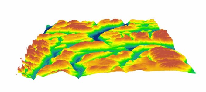
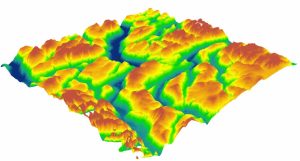
1. Space Shuttle Radar Topography Mission (SRTM)
SRTM DEM data is being housed on the USGS Earth Explorer. To download, select your area of interest. Under the data sets tab, select Digital Elevation > SRTM > SRTM 1-ArcSecond Global. But here’s a USGS Earth Explorer download guide to help you get started.
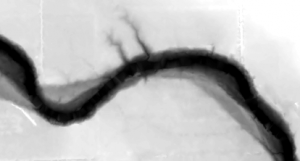
NASA only needed 11 days to capture the Shuttle Radar Topography Mission (SRTM) 30-meter digital elevation model. Back in February 2000, the Space Shuttle Endeavour launched with the SRTM payload.
In late 2014, the United States government released the highest resolution SRTM DEM to the public. This 1-arc second global digital elevation model has a pixel size of about 30 meters resolution. Also, it covers most of the world with an absolute vertical height accuracy of less than 16m.
2. ASTER Global Digital Elevation Model
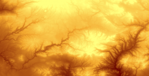
ASTER GDEM boasted a global resolution of 90 meters with a resolution of 30 meters in the United States. Despite its high resolution and greater coverage (80% of the Earth), dissatisfied users expressed issues with its artifacts often in cloudy areas. You have two options to download ASTER GDEM:
- This dataset is available on NASA Earthdata free of charge in the left panel under Instruments > ASTER.
- You can download the ASTER DEM data for free from the USGS Earth Explorer. Under the data sets tab, select Digital Elevation > ASTER.
ASTER GDEM used stereoscopic pairs and digital image correlation methods. Based on two images at different angles, it used stereo pairs and photogrammetry to measure elevation. However, the amount of cloud cover affected the accuracy of ASTER which wasn’t the case for SRTM DEM. Because of how passive and active sensors work, this had the most significant effect on the quality of DEM.
But over time, ASTER DEM data has improved its products with artifact corrections of their own. In October 2011, ASTER GDEM version 2 was publicly released, which was a considerable improvement. Despite its experimental grade, ASTER GDEM-2 is considered a more accurate representation than the SRTM elevation model in rugged mountainous terrain. But you should really take a look for yourself.
3. JAXA’s Global ALOS 3D World
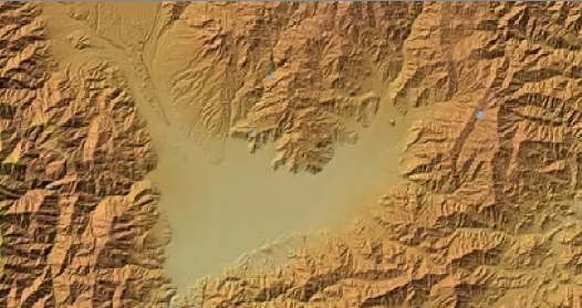
ALOS World 3D is a 30-meter resolution digital surface model (DSM) captured by the Japan Aerospace Exploration Agency (JAXA). Recently, this DSM has been made available to the public.
The neat thing about is that it is the most precise global-scale elevation data now. It uses the Advanced Land Observing Satellite “DAICHI” (ALOS) based on stereo mapping from PRISM.
Where can you download the JAXA’s Global ALOS 3D World? If you want this accurate DSM, you’ll have to register online through the JAXA Global ALOS portal to download it.
4. Light Detection and Ranging (LiDAR)
Slowly and steadily, we are moving towards a global LiDAR map. We’ve put together a list of some of the 6 best LiDAR data sources available online for free.
Because nothing beats LiDAR for spatial accuracy. After you filter ground returns, you can build an impressive DEM from LiDAR. And if you still can’t find anything in the link above, try your local or regional government. If you tell them what you are using it for, they sometimes hand out LiDAR for free.
5. Mars Orbiter Laser Altimeter (MOLA)
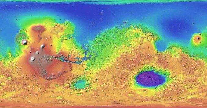
Just throwing this out here to pique your interest. We aren’t only mapping out Earth’s elevation. In fact, scientists used MOLA to map out ancient streams on Mars. If this doesn’t excite you, I don’t know what would.
Based on the Mars Orbiter Laser Altimeter (MOLA) instrument, you can view the rugged terrain of Mars. For example, this Mars Terrain map uses data from MOLA.
Where can you download the MOLA DEM of Mars? The USGS Astrogeology Science Center is the DEM data hub for Mars. USGS found elevations above the areoid from a Martian gravity field solution GMM-2B with a total elevation uncertainty of at least ±3m.
How to Download DEM Data
Elevation data is abundant. It’s just a matter of finding the right one to suit your needs.
From spaceborne to airborne, from Earth to Mars – you now have the right DEM data to ascend to data-driven altitudes.
It’s also possible to simplify your DEM data search by using Equator. Find and download high-quality DEM and LiDAR data. It’s like a shortcut. But coverage varies by region.
Got anything else? Please let us know with a comment below.


je Vais utilizer voter site pour les etudes
I want NDVI for my FYP
Thanks for referring to these sources.
Good
You might think that finding LiDAR is a shot in the dark.
>______________________>
Hi, I need data DEM data for Sahamalaza-Iles Radama National Park in NW Madagascar. Can you help? Thanks
You can use our guide for using the USGS Earth Explorer. This has elevation data outside the United States as well. Check out the “SRTM” dataset for an example. https://gisgeography.com/usgs-earth-explorer-download-free-landsat-imagery/
Hi, I’m looking to find a DEM basemap of Riau, Indonesia – could you direct/assist?
Hello Ellie,
Did you get your Riau DEM and SHP? Could you share some of them with me please?
Thanks a lot for your very useful information!
Just a short update: The path for the ‘ASTER Global Digital Elevation Model’ on ‘USGS Earth Explorer’ has changed: It’s now: NASA LPDAAC Collections > ASTER Collections. There you can choose from three collections!
Continue your great work at gisgeography.com!
Best wishes, Albert
Hello,
Need help finding a DSM for Puerto Rico. Thanks!
I need to get 10 mt resolution contoure
Is the shuttle radar topography mission still working at the source of DEM 2020?
I would like to get the DEM for boreholes in Uganda and most specifically for Busia district in Eastern Region of Uganda
The USGS has digital elevation models. Here’s a guide how to download – https://gisgeography.com/usgs-earth-explorer-download-free-landsat-imagery/
Looking for a DEM file of “Cape Cod”
Is there any online website where older SDTS DEM data for the USA can be downloaded?
I’m interested in finding DEM’s for golf courses. Would anyone happen to know the best source. I don’t really know much about DEM’s but they can be used with a golf course creation program that I’m using. I have no idea what’s actually available, but is it possible to find 1 foot data for small areas such as golf courses?
Thanks, and any advice on this would be greatly appreciated.
Dan
You would need LiDAR data for that. Please check out our list of free LiDAR data sources – https://gisgeography.com/top-6-free-lidar-data-sources/
Thanks for the links!
P.S.
“Just throwing this out here to peak your interest.”
Pique is the correct term unless you were intentionally misusing the word to make a GIS pun. ;)
Hey I want topography surfaces i.e topo surface for a size of a building in different regions of Germany. Which source could be more accurate according to my location and criteria. I will be exporting that topo surface to Autodesk revit and there i will use it as a filter so that which of my building can reside on that topography
Hello is NASA DEM yet released in 2019?? If yes where can I get it?
If NO when will it be released??
I am on the Earth Explorer page but I do not see where I can find astgtm2 files. Can anyone help me? Thanks
Hey, which source has latest DEM for Europe? I have tried USGS and the acquisition date is 2002.
Hey, what program should I use for opening DEM-Imagery (so far TIF’s) I’ve downloaded? And what steps do I have to follow to get a nice height map?
I’m using so far Photoshop. But the image modus seems to be set off. And when I change it to 32 bit and then back to 8 bit I still have complete white areas, what would disiturb a 3d elevation mesh.
Hi Matthias. As far as I know, both Adobe Photoshop and Illustrator don’t recognize DEM files. You’ll need a GIS program such as QGIS. Any of these software programs in the link below will be able to open a TIF. And for most of them, you can just drag and drop the TIF file from windows explorer directly into the program. I’ve listed our favorites from top to bottom. https://gisgeography.com/free-gis-software/
Hi, I have been trying to download ASTER and SRTM data from USGS’ EarthExplorer but no luck. The region that I am searching is:
1. Lat: 1.5087, Lon: 127.6747
2. Lat: 1.5087, Lon: 127.6055
3. Lat: 1.4469, Lon: 127.6055
4. Lat: 1.4469, Lon: 127.6747
but there is no results found.
Could someone help me explain why? I am newbie to GIS data.
Hi, I’m a Telecom Engineer heading into GIS concepts now for my projects. I found the information here very useful – the JAXA’s global DSM was just what I needed. Thanks a lot!
However I’m facing some problems when converting the coordinate system from GEO to UTM for later export as GRD format for importing into my planning tool. At southern negative latitudes (ex. around 30S-50W Brazil), it comes out with a distortion of few kilometres that cannot be corrected for the whole map. How do I avoid this distortion? I’ve used Global Mapper for converting. Could you help me on this?
Hey, I have xyz details survey, I need to create a DEM, which software can I use
You can interpolate the z-values with QGIS, SAGA GIS and ArcGIS. Here are some options for you. https://gisgeography.com/free-gis-software/
Hi
I am looking at creating DEM using a drone and will be using a 12MP RGB camera and a NDVI camera?
Can any one help me how to generate a good DEM of land and also crop?
For crops, it really depends on the time of season, stage of growth and types of crops for any NDVI analysis. You’ll have to give a bit more detail on what you want to accomplish for the DEM too
I want to download a 10 m resolution DEM for India. Can I get some suggestions for that
Nice list, thanks for featuring OpenTopography. For what it is worth, you can also download SRTM 30 and 90m (#1 above) and JAXA’s Global ALOS 3D World (AW3D30) data (#3 above) from OpenTopography.
There’s also a RESTful Web service for programmatic access to these datasets: https://opentopography.org/developers#SRTM
I need DEMs with 10 resolution in Canada, Australia and Europe. But do not know where I can download.
I don’t see SRTM on Digital Elevation…
It has it’s own group and drop-down
Thank you so much! The JAXA data was just what I needed!
Hi-does anyone here have a suggestion of software I can use to help bring out deep details in mountainous terrain? I’m studying Geoglyphs and Earthworks, ancient fortifications etc. I’ve been finding some very intriguing sites in South America I have about 15,000 images I’ve taken using Google Earth and need to step it up a bit to confirm this data. I’d appreciate any help, thx
Thanx for the list. There’s an Android-App which gives you a pretty good detail level. Its called DEM1. I like it so far in use with the Mapping-App OruxMaps.
ASTER GDEM is a 30 m resolution for 80% of globe not just for USA. This is for version 1 and 2
Thanks for nice overview! However, I just discovered a serious mistake .. the Alos World 3D model is produced from stereo-imagery (the PRISM) and not PALSAR’s L-band!
See the reference https://isprs-archives.copernicus.org/articles/XL-4/243/2014/isprsarchives-XL-4-243-2014.pdf
“Panchromatic Remote-sensing Instrument for Stereo Mapping (PRISM), one of onboard sensors carried on the Advanced Land Observing Satellite (ALOS), was designed to generate worldwide topographic data with its optical stereoscopic observation.”
Thanks very much for that.
WorldDEM is the future. It’s from Airbus and DLR but not for free yet.
https://www.intelligence-airbusds.com/en/8703-worlddem
“WorldDEM™ will thus replace the 10-year-old SRTM.”
Good
Thank you!
It’s there. You’ll have to click the “+” button to expand. It goes from ASTER to LiDAR, and a whole new category below LiDAR for SRTM
I don’t see SRTM on Digital Elevation…