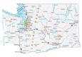
Washington Lakes and Rivers Map

About the map
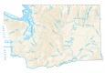
This map shows major rivers, reservoirs, and lakes of Washington like Lake Chelan. In general, the rivers and streams of Washington flow into the Pacific Ocean.
Lake Roosevelt is the largest lake in the state of Washington at 82,000 acres, more than doubling the second largest Lake Wallula. Next, Lake Chelan, Potholes Reservoir, and Banks Lake are the next largest. Columbia River, Snake River, and Yakima River are the longest rivers in Washington state. In fact, the Columbia River forms a border with Oregon, separating it from Washington.
Washington has a lot to offer when it comes to water activities, from swimming in lakes to kayaking on rivers. Lake Union in Seattle is a popular destination for swimmers, as well as kayakers who can explore the scenic waterway.
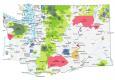
Washington map collection

You are free to use our lakes and rivers map of Washington for educational and commercial uses. Attribution is required. How to attribute?
Washington lakes, rivers and reservoirs
Lakes and reservoirs
Franklin D Roosevelt Lake
Potholes Reservoir
Lake Chelan
Banks Lake
Ross Lake
Ozette Lake
Lake Wallula
Moses Lake
Rivers and streams
Quinault River
Cowlitz River
Columbia River
Skagit River
Snake River
Spokane River
Pend Oreille River
Okanogan River
Nisqually River
Chehalis River
Skykomish River
Wenatchee River
Yakima River
Methow River
Naches River
Klickitat River
Lewis River
Puyallup River
Touchet River
Tucannon River
Palouse River
Sanpoil River
Entiat River
Nooksack River
Toppenish Creek
Lower Crab Creek
Union Flat Creek
Rock Creek
Hangman Creek
Water features
Admiralty Inlet
Hood Canal
Willapa Bay
Grays Harbor
Strait of Juan de Fuca
Strait of Georgia
Puget Sound
Pacific Ocean
Missing lake whatcom
Missing Yakima river
Actually, it’s on the map. Take a closer look. The label is in the bottom center of the map.
its missing the location of strait of gorgia
Missing Sol Duc
missing the point of lakes
Missing Lake Washington
Missing the tieton
its not missing yakima river gang its at the bottom of the map where yakima is