US Election of 1928 Map
In the presidential election of 1928, Herbert Hoover dominated with 444 electoral votes. His democratic party opponent, Al Smith picked up just 82 in total.
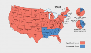
In the presidential election of 1928, Herbert Hoover dominated with 444 electoral votes. His democratic party opponent, Al Smith picked up just 82 in total.
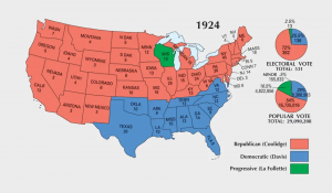
In the election of 1924, Calvin Coolidge remained the 30th president of the United States. He defeated both contending parties with 382 electoral votes.
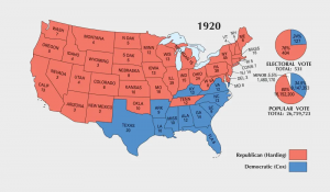
For the 34th presidential election, women received the right to vote. After the voting, Warren Harding easily won in a landslide with 404 electoral votes.
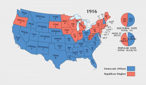
In the election of 1916, Woodrow Wilson won re-election edging out Charles Hughes. But it was close. While Wilson gained 277 electoral votes, Hughes had 254.
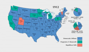
In the election of 1912, Woodrow Wilson surprisingly defeated both Taft and Roosevelt by a wide margin. He became the 28th president with 435 electoral votes.
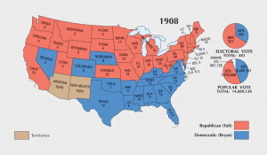
In the presidential election of 1908, William Howard Taft easily defeated Bryan. Taft became the 27th president winning 321 electoral votes in total.
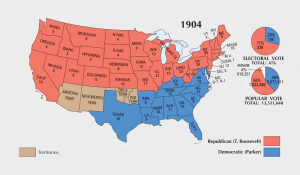
The 1904 US election turned out to be a landslide victory for Theodore Roosevelt. Overall, he earned 334 electoral votes compared to just 140 from Parker.
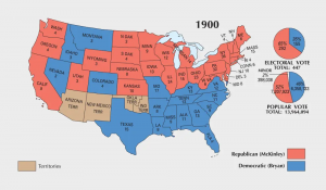
In the election of 1900, William McKinley was elected again gaining 292 electoral votes. But he was assassinated. Then, Theodore Roosevelt took his place.
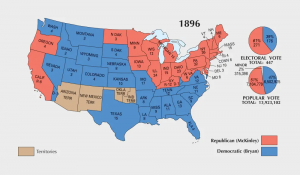
In the US Election of 1896, William McKinley became the 25th president of the United States. He gained 271 electoral votes with Jennings receiving just 176.
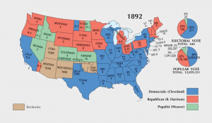
In the election of 1892, Grover Cleveland made a triumphant return. He became the 24th US president with 277 electoral votes defeating Benjamin Harrison.