CARTO (CartoDB) – The Geospatial Platform in the Cloud
An Overview of CARTO
One of the big issues today is that we don’t know how to use the growing demand for data to visualize and analyze. This is where CARTO comes in. CARTO is where data meets maps on the web.
Instead of using desktop GIS software, CARTO provides it all in the cloud. As long as you have an internet connection, you can access it with just a web browser.
The best part?
You don’t have to worry about updates, backups, or the need to set it up. Let’s take a closer look at this web mapping platform, formerly called CartoDB.
How Does Carto Work?
Behind the scenes, CARTO leverages PostgreSQL + PostGIS as a web service. That means you the user can have complete control of a fully managed database.
Here is a simple architecture diagram for how CARTO works.
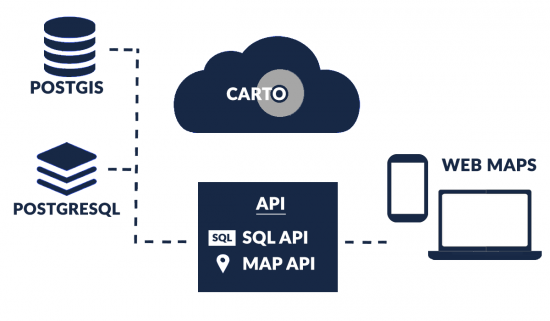
Developers build custom tools around CARTO’s APIs. Specifically, the two key APIs are the following:
- SQL API – By using the SQL API, you can insert, update, and delete records with your tables using SQL statements.
- MAPS API – The MAPS API gives you the capability to create maps using data hosted in your CARTO account.
Remember that PostgreSQL is an open-source object-relational database system. Then, PostGIS extends its capabilities for geographic objects.
5 Things We Like
CARTO is the leading cloud-native location intelligence platform for GIS scientists and professionals. Development in CARTO has been remarkable. Here is a list of what we like the most about it:
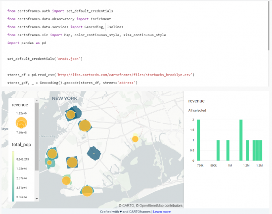
1. CartoFrames
These Python packages are like dynamic notebooks you can interactively update on the fly. It allows you to integrate data and maps from your CARTO account into your current environment.
Here’s an example of using Cartoframes.
2. Machine Learning
CARTO specializes in those types of projects where you dig deep into the data. In CARTO, it’s possible to embed machine learning by using SQL call statements.
By integrating CARTO with Databricks, you can transform big data into quantifiable solutions through machine learning models.
Combining the power of CARTO and Databricks enables you to unlock valuable insights from your data. This can give your organization to make data-driven decisions with confidence.
3. Geoenrichment
Geoenrichment is about enhancing your feature attributes by using location. For example, you can geoenrich your data streams based on points of interest, demographics, and financial information.
Geoenrichment provides a holistic view of your data. It allows you to make more informed strategies based on geographic factors that shape your business landscape.
4. Solution Tools
If you need a set of tools that perform a specific function, then the CARTO platform can help. For example, tools include site selection, territory planning, and vehicle routing to help tackle business challenges.
These tools are designed to streamline your decision-making processes and optimize operations, making the CARTO platform an invaluable resource for businesses looking to gain a competitive edge in today’s market.
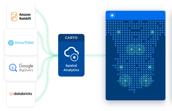
5. CARTO is cloud native
The biggest benefit of a cloud-native approach is the ability to leverage cloud computing resources and technologies that are highly scalable, flexible, and efficient.
But the key is that CARTO allows you to connect to your data sources seamlessly. For example, this includes everything including Google BigQuery, Snowflake, Amazon Redshift, and Databricks.
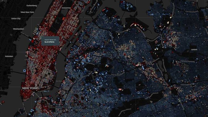
How To Visualize Data
The power of CARTO as a platform is how it serves underlying data as tiled web maps. You get a high level of control for cartography with a display that’s smooth and pleasant to the eye.
CARTO for deck.gl is a powerful WebGL framework for large-scale datasets. But you can also build web maps using Google Maps and Mapbox GL.
Admittedly, it can be a bit of a steep learning curve. On top of SQL, you need basic skills in web programming languages like HTML, CSS, and JavaScript.
Although CARTO is mostly tailored to programmers, you don’t need experience in web development for some of its solution-based web mapping functionality.
How Much Does CARTO Cost?
CARTO has a range of options for pricing. They have a generous free tier that gives you a trial for one full year.
Otherwise, the difference you pay is based on the number of datasets, map loads, and API access. It also sets a limit on the number of public and private maps.
In our web mapping platform analysis, CARTO is one of the leading web mapping platforms in the industry, today.
Today, companies like Mastercard, Vodafone, and JLL are using CARTO to power their online mapping and geospatial analysis.
READ MORE: 5 Best Web Mapping Platforms – The Battle of Web GIS


