3D Maps: A Complete Guide To See Earth in 3D
Today you’re going to see the best 3D maps in action.
These aren’t your traditional top-down satellite maps.
Instead, you can interactively fly around buildings and landscapes in three dimensions.
Let’s start exploring.
1. Google Earth
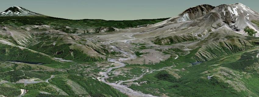
Almost in a league of its own, Google Earth has mind-blowing detail in its 3D maps. The architecture in cityscapes shows bridges, towers, monuments, and even rollercoasters.
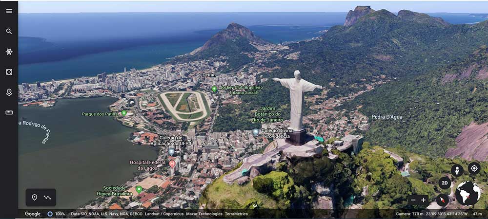
“Google Earth has 20+ zoom levels with the most basic as Landsat. It’s when you zoom into metropolitan regions that you see a mix of realistic 3D textured buildings, bridges, and even rollercoasters.”
Yosemite is an example of the amount of detail that a photogrammetric mesh can capture. It has everything you’d expect to visit there like the towering granite monoliths, deep valleys, and ancient giant sequoias.
But how are 3D buildings and landscapes generated in Google Earth? It’s actually a combination of two types of 3D feature types:
- SKETCHUP 3D MODELS: In the past, most of Google Earth’s 3D models were created from SketchUp. Google bought the company some time ago. They started giving the software away free. But users can’t submit their 3D models to Google Earth anymore. The biggest downfall was that SketchUp was a manual process. Think about the time and effort it would take to create millions of high-rise buildings across the world. Enter automated stereophotogrammetry.
- AUTOMATED PHOTOGRAMMETRY: The only answer for Google Earth was to create automated 3D models with stereophotogrammetry. Google Earth doesn’t use satellite imagery for this process. Instead, it uses planes that zig-zag back and forth. When you have overlap, photogrammetry pulls all the photos together in a textured 3D mesh. It’s the side-angle cameras that paint the texture along the sides of mountains and building walls.
If you want more information, Google explains how they build their maps with such attention to detail.
READ MORE: Google Earth vs Google Maps: What’s the Difference?
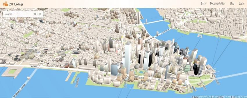
2. OpenStreetMap (OSM-3D)
OpenStreetMap is a collection of individual accomplishments working toward a common vision – a free updated map for the community to build and explore.
The OSM community is famous for organizing “mapathons”. At these public gatherings, mappers from around the world trace areas out in different locales. This is why we see large pockets in specific areas.
For OpenStreetMap (OSM) 3D maps, it’s a bit scaled-down. The OSM community is enormously active. It has a big heart. But it doesn’t have the deep pockets for large photogrammetry projects. Some examples of its 3D maps are in OSMBuildings.
OSM BUILDINGS: There are countless web applications that incorporate OSM data. But OSMBuildings is one of the best for 3D exploration. For example, this is what 3D looks like in Manhattan, New York. But for other cities, you might find the bare minimum.
3. ArcGIS Earth
Esri’s ArcGIS Earth is a different flavor of 3D maps. You download it as an application on your desktop or phone. As you tilt your view, the terrain is completely in 3D.
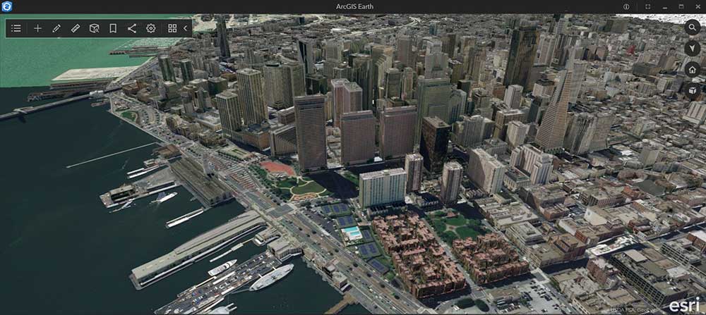
But if you’re looking to see buildings, they’re not there in the start-up. You’ll have to see what’s available by searching on ArcGIS Online. 3D data exists from a variety of sources.
For example, the Golden Gate Bridge looks phenomenal. But there are also cases where buildings aren’t realistic like for the City of Berlin. It’s a decent alternative. Just be aware that it’s still a work in progress.
4. Apple Maps
You don’t feel as open in Apple Maps compared to the rest of the 3D maps. It’s because you won’t be able to find a website that has any of its 3D maps in it. So if you have friends with iOS, this is the only way to see it.
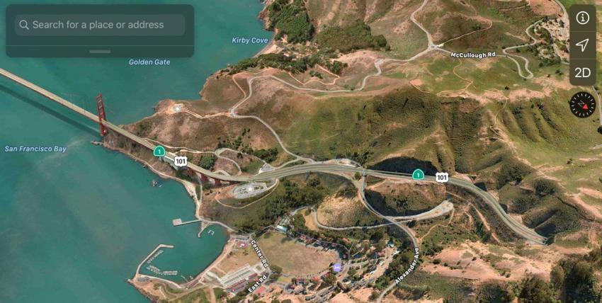
After you connect to Apple Maps in iOS, you can see an improving platform. All the time, money, and effort that Apple has poured into its mapping interface is starting to pay off.
One of the best features of Apple Maps is its flyover mode. A flyover is a way to get a virtual tour in the air of a city or place. Flyover modes give an immersive view as if you’re getting a virtual tour.
5. NASA World Wind
NASA World Wind is different from the other 3D maps in this list. It’s a software development kit (SDK) that has all the necessary tools for you to create and build your own customized mapping applications.
It’s completely free, open source, and cross-platform. The 3D virtual globe had a large collection of built-in imagery and terrain. It’s compatible with:
- COLLADA 3D models
- Keyhole markup language (KML)
- Web mapping services (WMS)
And just recently announced, the development will continue being supported into the coming years.
Summary: 3D Maps
3D data is exploding in usage. It’s not only 3D mapping platforms but 3D analysis is growing.
These were the top 3D maps that we thought were above and beyond.
To recap: If you want to see existing 3D views, then you should choose.
- Google Earth
- Apple Maps
- OpenStreetMap (OSM)
If you want to make 3D maps your own, check out:
- ArcGIS Earth
- NASA World Wind
What’s your favorite? What did we miss? Please let us know with a comment below.


3d
I want a 3 dimension plaster (maybe) model od my 50 area farm in North Carolina.
it there a way? IF so, point me the direction
Under Google Earth above you mentioned legacy 3D models and the newer photogrammetry models. You did not point out that all of the legacy models still exist in Google Earth and can be displayed. Some display by default as they have not yet been superceded by photogrammetry versions. Examples include Machu Picchu in Peru and Martin Luther King memorial near the Lincoln Memorial in Washington DC. The rest can be displayed by changing a settings option in Google Earth as follows:
– Click Tools at top left
– Click Options
– Select the 3D View tab at the top left if not already selected
– In the Terrain group 3/4 of the way down untick the “Use 3D imagery” box
– Click OK
– You naturally also have to tick the box next to 3D Buildings on the left under Layers after you exit from Tools.
Just be aware that you will sometimes have to wait for a while for the model to be displayed in full detail, especially on a slower PC. (The same is true with photogrammetry models). Sometimes the legacy models will also float above the terrain, if the Google terrain has been changed since they were created.
The legacy models are usually far more detailed and accurate than what is created via photogrammetry.
A good example is Christ the Redeemer statue in Rio, which you show a picture of above. Viewed from a distance the photogrammetry version looks reasonable. Zoom in and it is basically a featureless blob. Compare that with the original manually created version (modelled by yours truly). The entire mountain is modelled in excrutiatingly accurate detail. You can even go inside the chapel in the base of the statue, where all of the furniture, light fittings etc. are modelled. See https://www.youtube.com/watch?v=zn5w40Ln9wg
A similar level of detail can be found in many other legacy models around the world, eg. Pompeii. Many of them can be downloaded from the Sketchup 3D Warehouse.
Another significant capability of Google Earth that none of the other platforms have is true 3D animation. To see what is possible check out the following YouTube videos of 3D Google Earth animations created with Sketchup and the KML markup language. You can run them yourself (or get ideas for creating your own). Just download the KMZ file from the 3D Warehouse via the second links given and double click on them to run them in Google Earth. Usually after you open them in Google Earth you will have to double click on a link at the left where indicated to start the animation and click on the little play triangle on the time slider that pops up. For the technically minded a KMZ file is simply a zip file. Just make a copy and rename it to end with .zip instead of .kmz. You can then open it and see its contents. There will usually be a file inside called doc.kml which contains the main animation code. Open it with Notepad.
Disneyland Monorail
https://www.youtube.com/watch?v=UmAZTp0SlJA
https://3dwarehouse.sketchup.com/model/4fdeb016355f491948846c67671d9660/Disneyland-Monorail-Animated-Short
https://3dwarehouse.sketchup.com/model/878c7c0d00936a6848846c67671d9660/Disneyland-Monorail-Animated
Disneyworld Monorail
https://www.youtube.com/watch?v=x-Kz6Vojbx0
https://3dwarehouse.sketchup.com/model/be132bf12b47244048846c67671d9660/Disney-World-Monorail-Animated
Costa Concordia Shipwreck
https://www.youtube.com/watch?v=DhwW6FlL9ow
https://3dwarehouse.sketchup.com/model/57e14f9b30152cb51f2b60986ab4327c/Costa-Concordia-Disaster-Animation
Tenerife Airline Disaster
https://www.youtube.com/watch?v=glZIggnP47Y
https://3dwarehouse.sketchup.com/model/b95cbcb2a669fa2fa1ed68d685caf3ad/Tenerife-Airport-Disaster
Spanish Train Crash (short version)
https://www.youtube.com/watch?v=-SzOneaSMF4
https://3dwarehouse.sketchup.com/model/449581d889e325c4dfd89dd71a555b12/Spain-Train-Crash-Animation
Spanish Train Crash (full version)
https://www.youtube.com/watch?v=fM1oBDw08x4
https://3dwarehouse.sketchup.com/model/cf8544f0c3074395dfd89dd71a555b12/Spain-Train-Crash-Animation-Detailed
Ferris Wheel at Luna Park in Sydney, complete with animated shadows
https://www.youtube.com/watch?v=HnSTxGONuiE
https://3dwarehouse.sketchup.com/model/e444bb6f2114aae448846c67671d9660/Luna-Park-Ferris-Wheel-Animated
Enjoy.
Very nice. Thank you. This is a great. I wish there was more like this on the web.