The Hidden Powers of QGIS 3: Features and Plugins
QGIS 3 has landed. When QGIS releases a new version, it’s kinda a big deal. Because the unsung heroes of open source GIS software are back in action! It’s their third big release. QGIS 3!
So buckle up, because we’re about to take a joyride through the lands of geospatial awesomeness – no compass required!
QGIS 3 Ratings
Mapping
Analysis
Editing
Data Support
Ranked #2 from 30 GIS Software
Pros/Cons of QGIS 3
Here are some of the advantages and disadvantages of using QGIS 3 compared to other GIS software applications.
PROS
CONS
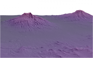
1. Simulating landscapes in 3D
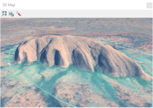
The rumors are true. QGIS 3 now brings an interactive, fully integrated interface for you to work in 3D.
A year ago, QGIS relied on plugins like qgis2threejs. Whereas now, QGIS 3 has adopted 3D natively.
We’re genuinely excited about this one. It’s slick and has the power to transform your data and visualizations.
Believe the hype. Cheers to QGIS 3 for putting 3D in the palm of our hand. Just check out some of these maps made with QGIS.
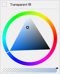
2. Giving life back to mapping
Ironically, one of the biggest problems in most GIS software is its lack of tools to build unforgettable visualizations.[1][2][3]
Turns out, QGIS distinguishes itself as a leader in cartography. This is because it places practicality and usability above all else.
Some of my favorites:
ALPHA SLIDER: For setting transparency, the alpha parameter is a value between 0 to 1. While 0.0 is fully transparent, 1.0 is fully opaque.
COLOR RAMP WIDGET: Now, QGIS 3 remembers color ramps per projects and as favorites. Most importantly, there are loads to choose from like ColorBrewer and cpt-city.
3. The Need for Speed
Quietly on its quest, QGIS unquestionably qualifies for quickness. Because when you can pan, zoom, and load features in the blink of an eye.
Fastest GIS software in the West.
Everything is slick in QGIS 3. VERY powerful. Extremely, EXTREMELY fast.
Panning and zooming with large data from Geopackage, and file geodatabase is like GIS on steroids. And cached labeling gives faster rendering and redraw times.
4. Placing labels manually
When you have overlapping labels, the traditional approach is either to generate annotations or alter the layer’s placement settings. However, this often results in something messy or completely ineffective.
While most GIS software touts smart label placement [1][2], they never are. The best idea that I’ve seen so far is how you can just pick up and move labels in QGIS 3. Also, you can hide, shift, and style single labels.
Instead of producing annotations, QGIS 3 takes a minimalistic approach that puts the user in the driver’s seat. Big up to QGIS 3 for giving users complete control of their map labels. It’s been a head-scratcher for years.
5. Previewing coordinate reference system bounds
The theme surrounding QGIS 3 is its inventive, new ideas to improve user experience. Adding to the list, users can ensure they have valid coordinate systems by previewing their valid bounds.
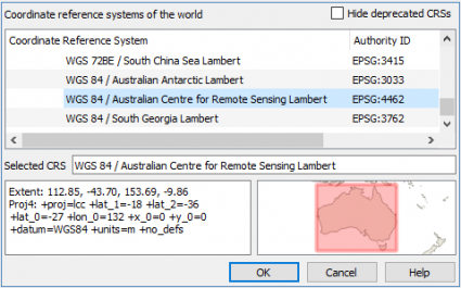
When you go into the CRS project properties tab, it shows graphically relevant coordinate systems. For example, here is a valid extent for Australia.
QGIS always reinvents its software with lots of fresh ideas. It always puts users first. In today’s modern GIS environment, this type of user-first thinking is all too welcome.
6. Editing with ease
Regardless of your experience with editing data, QGIS 3 has a couple of new editing tools so you can work more comfortably.
- Tracing at offsets.
- Tracking edits from multiple users.
- Editing features that stick to topology.
- Querying between numerical values.
- Easier shapes with new CAD tools.
Again, QGIS 3 is crammed full of high-quality editing tools modernizing the experience.
7. Packaging anything in a geopackage
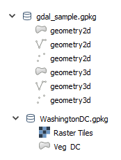
In QGIS 2.8, shapefile was the default file format for output. Now in QGIS 3, the standard output format is a Geopackage.
You really have to know what’s so special about Geopackage (.GPKG) to know why QGIS 3 made this change. This self-contained serverless SpatiaLite database can contain anything from vectors, tiles, rasters, layer attributes, and even extensions.
Unlike shapefile which had 3 mandatory files, this open standards geospatial container is easy to share because it’s all contained in a single file.
8. Enabling background processing
Instead of waiting during a process, QGIS 3 has added background tasks. This means that you can continue your workflow as you naturally do when running a task.
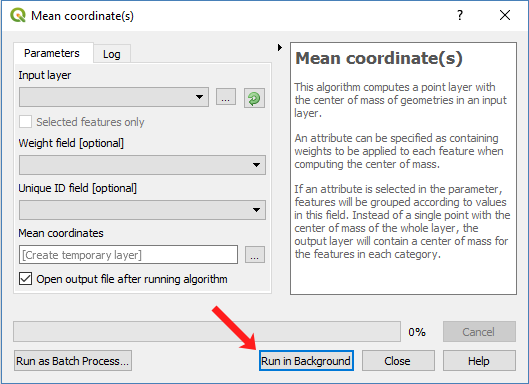
If you want to turn on background processing, the option is available when you run the tool.
This type of seamless environment adds up to something special to the user. It allows you to keep doing your work when processing churns away in the background.
9. Reprojecting while geoprocessing
A nice feature is how you can automatically re-project your layer by setting it up in the algorithm.
For example, if field crews collect data with a handheld GPS, points will be in WGS84. If you want to buffer these points and project them, you can do this all at the same time.
Instead of going through the intermediate step of projecting data and creating a new file, you can do both. To say the least, this is a big time-saver for GIS professionals.
READ MORE: QGIS Tutorial: How To Use QGIS 3
10. Convenience worth its weight in gold
Whether you’re a veteran user, casual user, or even someone who has never done GIS before… QGIS 3 has added convenience worth its weight in gold.
If you worked with QGIS 2.18, then you will be able to open these projects in QGIS 3. But you won’t be able to open them the other way around.
When you have multiple panes, you can stack them up into tabs. Unlike ArcGIS Pro, QGIS 3 doesn’t have contextual ribbons (which I’m digging into). But for the traditional QGIS user, I think this approach just makes more sense.
11. Locator search bar
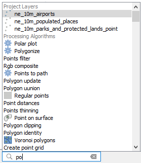
On the topic of analysis, another way to find algorithms is to use the locator search bar. Not only does it have geoprocessing algorithms, but you can locate active layers, features, and algorithms.
That’s right. If you have a long list of layers on your map, just type it in. Next, it will auto-complete until you select it. Finally, it will be highlighted on your map.
If you want to use the locator bar, it’s in the bottom-left of QGIS. This means no more delving into your menu to find the right tool or feature.
12. Displaying in high definition
QGIS has always been on the cutting edge for display. It’s light years ahead for cartography with almost limitless potential.
Maps are super crisp in QGIS 3. They are beautiful to look at. And they always have been a cut above the rest in Print Composer and map canvases.
Now, you have the option to directly tweak map canvas exports with customized settings. For quick exports, luckily QGIS 3 executes this masterfully. Even your grandma would hang your maps on her fridge.
13. Perfecting your map layouts
The QGIS mapping interface is called ‘Print Composer’. It acts almost like a separate application. QGIS 3 has reworked its print composer with a brand new layout engine.
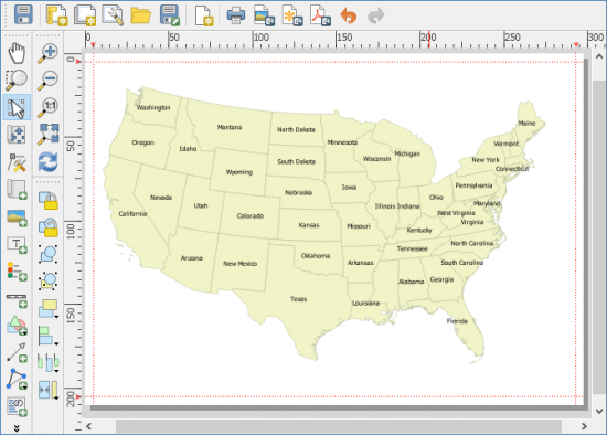
Now, you can snap your layouts with the guide manager for exact positioning giving it a clean, polished look. The key here is finding where to snap to via the layout guidelines.
Also, there are refreshing changes in how you resize and distribute elements.
14. Unifying add layer toolbar
Adding data in QGIS 3 could have been just another set of random buttons. But QGIS 3 takes a massive leap forward with the Data Source Manager.
The unified data source manager transcends beyond a single format. Without restrictions, you can connect to GIS data sources including ArcGIS online features vector, raster, and more.
Also, the QGIS browser panel adds easier functionality to find data. Then, you can even drag and drop data in your map canvas.
15. Make geoprocessing great again
As always, QGIS comes with an incredibly polished set of geoprocessing tools. But what’s important to note is how refined and cleanly put together they are. For example, QGIS 3 organizes tools in a much more intuitive way so they’re easier to find.
A lot of these features have been rewritten from scratch in C++. Luckily, this means it’s more stable and has better performance which separates it from other GIS software.
Lastly, QGIS 3 comes with a revised and expanded set of tools. For example, raster analysis now includes ruggedness, slope, and hillshade by default.
16. Displaying multiple canvases
One of the elements that every map often forgets to incorporate is 3D. But now that 3D is built-in QGIS 3, how about both in 2D and 3D at the same time?
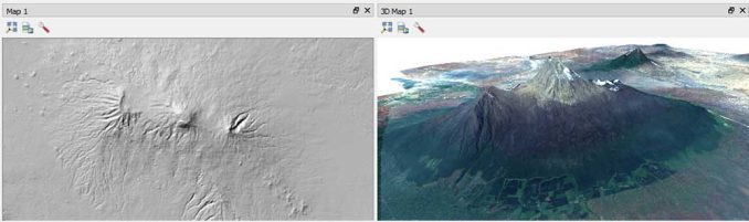
The approach you should take is to use multiple canvases. For now, each canvas can’t sync together. At least that I could see.
For anyone who wants to showcase several layers at the same time, it’s refreshing you can now do so. And that’s just what I did with Mount Kilimanjaro in both 2D and 3D from our list of free satellite imagery sources.
17. Going above and beyond with Python 3
An incredible amount of work went into QGIS 3 including moving Python 2 to 3. QGIS 3 gives the option to run Python scripts directly in the browser.
Python within QGIS can enhance functionality beyond traditional commands and solve more complex and dedicated problems. For example, powerful libraries like Pandas, Numpy, and Scikit extend GIS into data science.
Python 3 is a major milestone for QGIS 3. If you really want to automate and extend, you must learn Python.
18. Tables and graphing
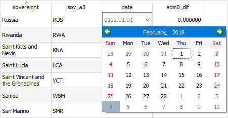
One of the major highlights is how tables have become more user-friendly. Just like how tables resize vertically to fit the text.
When you start editing a table, you begin noticing the expanded set of table editing tools. For example, date fields have calendars for selecting dates. And booleans have checkboxes.
Also, copying and pasting features into a Word Processor is a simple CTRL-C and CTRL-V. Instead of exporting a table, it’s easy to paste tables into external applications.
19. Seducing your colleagues with effects
QGIS 3 goes above and beyond expectations for cartography. If you give it a try, you can utterly seduce your colleagues giving a sense of pride and workmanship.
For example, topological coloring enables you to separate colors from neighboring polygons. This way, you can get that color separation in your maps
The selection of opacity can help your maps near perfection. On top of that, adding gradient fills for annotations completely differentiates your maps from the rest.
20. Clustering points at different scales
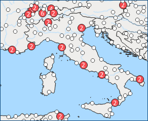
When you zoom out on a map, it can be difficult to see the number of points because they overlap each other.
This is why the new cluster renderer groups nearby points into a single rendered marker symbol. Then, it lists the number of points that the new one represents. This makes a logical choice next time you want to count features on a map at a small scale.
Just when you think QGIS has run out of ideas, it’s more inventive and creative than the last. And the other symbology rendering is impressive like heat maps or displacement for points and 2.5D rendering for polygons.
21. Expanding the list of plugins
If you’ve ever used QGIS before, then you know their enormous list of plugins is like your Holy Grail. This open approach has done exceedingly well and is by far the most active open source GIS project by a mile.
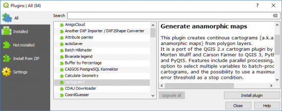
Every day, developers are migrating their plugins over to QGIS 3. Unfortunately, some of your favorites may not have been migrated at the moment.
But hang on tight. Without a doubt, plugins will remain a centerpiece in QGIS 3.
22. Auto-complete everything
QGIS 3 rolls out a new feature that quietly changes the GIS user experience forever. When users begin typing a word, it suggests existing entries based on their keystrokes.
And not only does this apply when you query attributes, but it applies to the locator search bar as well. So this means that if it’s on the tip of your tongue, just start typing it… and auto-complete will probably just suggest it to you.
If you want to find a value with auto-complete, press F3 with a layer. Basically, auto-complete rewrites the rule book.
23. Styling rasters
In QGIS 3.0, the handling of color ramps has gotten much better via a newly introduced color ramp button widget.
Again, QGIS spruces up your maps with beautiful preset color ramps. This means you can create a perfectly blended color ramp with the push of a button.
Also for single-banded pseudocolor and paletted renderers, you can now change the transparency for multiple values at the same time.
24. Basemaps and symbols galore
QGIS 3 doesn’t do anything to shake up the winning formula for symbology. As mentioned earlier, they’re crisp, load fast, and are what we all know and love.
And it still has some of the finest options for stacking your favorite symbols like its built-in SVG markers. For most of us, this is a staple of our daily work.
The problem is that it doesn’t deliver these symbols, to begin with by default. Off the get-go, we want to start rockin’ n rollin’ with a bottomless vault of symbols neatly organized. And unfortunately, you have to do a bit of searching and organizing beforehand in QGIS 3.
25. Automating dull stuff with Graphical Modeler
Just to be reminded of what it takes to make a great model in every sense of the word: input, algorithms, and output. And when you can string these processes together in Graphical Modeler, suddenly life gets easier because you can reuse them in the future.
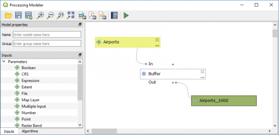
QGIS 3 refinements for the Graphical Modeler solidifies it as a key choice for automating. For example, this simple model sets an input parameter, buffers a set of points, and generates an output.
From start to finish, it runs quickly and smoothly without any snags along the way. And instead of a shapefile for output, it generates the new default geopackage output.
26. Designing reports
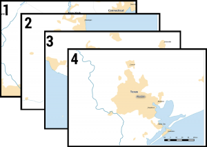
It’s a popular myth that you can’t produce well-designed reports in QGIS.
As you probably already know, Atlas mapbooks is how to assemble multi-page maps basing each view on an attribute. For some, this is a key automation tool and is used daily.
If you want to take reporting a step further by adding a bit more workmanship, the report engine seizes the moment. It helps you set up headers, footers, and everything in between.
27. Writing metadata
I admit. Metadata is not the sexiest topic. And metadata hasn’t attracted as much attention in QGIS 3.
But time and time again, metadata has proven to be a wise time investment. Because what happens when the originator of the data goes MIA? It’s the metadata that you will always go back to refer to.
In its first phase of development, QGIS has overhauled how it handles metadata. Based on its new metadata editing tool, QGIS 3 introduces its own internal, formalized metadata schema.
28. Setting your favorites
By assembling a cast of your favorite symbols, you can truly customize your maps and call them your own.
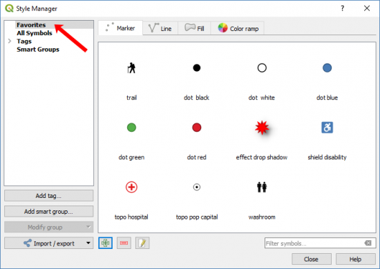
Not only can you save your favorite symbols, but you can save fonts as well. And just in case you don’t save your favorites, QGIS keeps track of your most recent for you.
And each user profile carries its own unique set of symbols really personalizing the experience.
29. Improving tabs and visibility
QGIS 3 allows for serious customization so you can really personalize it. For example, you can dock several panels together. These tabbed floating docks are for striking a great balance for screen real estate.
If you want to completely have your main layout in focus, it’s a matter of pressing Ctrl+Tab as a keyboard shortcut key. This command toggles for complete map visibility.
30. Selection by form
It’s sometimes the small things that count. When you want to select features by value, QGIS 3 has added a way to zoom or flash features that you select. Also, you can select, remove, and add features by selecting between a set of values.
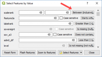
Alternatively, you can select an expression that requires some basic syntax for expressions. For example, you can select anything from geometry, fields, colors, and even fuzzy matching.
31. Data defined parameters
In QGIS 3, users can set up data-defined parameters from fields that drive geoprocessing tools. For example, you can buffer features based on a buffer distance field.
Instead of a static value, QGIS succeeds in a big way how you can dynamically use multiple values in a field. Also, you can use an “In Case” and “Else” statement based on categorical variables.
On the other hand, geometry generators render modified or new geometry based on values entered by the expression editor. In layer styling, this how-to creates geometry generators of your own.
32. CAD tools for easier shapes
To continue its theme of making easier digitizing tools, QGIS 3 has included tools to trace at a distance, track edits, and use simple calendar pickers for date fields.
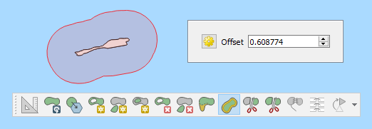
Of course, aside from all that QGIS 3 steps up to the plate offering a suite of CAD tools for better shapes. For example, when you create a rectangle, you can start from the center, from three points, or from the corner. This makes it a whole new ball game for CAD-style editing in QGIS.
33. Same old great license
Here is the ugly truth about commercial software: It is costly and you can do 99% of the same stuff with open source software.
Unlike proprietary software, you don’t have a license except for the GNU General Public License. Users from around the world embraced QGIS 2 as the #2 option for GIS (behind Esri). And now, QGIS 3 is flying off the shelves (virtually of course).
If you’re horrified by the high cost of license fees, then QGIS 3 far surpasses expectations. Instead of shelling out for a commercial license, QGIS still stands the test of time as unquestionably the #1 open source GIS software.
QGIS 3 Review and Summary
It’s QGIS best release in its lifetime. And this is a toweringly grand achievement because they’ve already redefined GIS software at least twice. (QGIS 1 & 2)
So now 2.18 is the LTR. And 3.0 is the regular release.
Cut to the chase. The developers of QGIS 3 have poured the same creativity and imagination into this thing to once again change the game.
QGIS 3 is a remarkable piece of open source GIS software. Don’t miss your chance. A positive GIS experience.
What are your thoughts? Let us know with a comment below.
And don’t forget
I want you to imagine a world where mapping doesn’t come with a price tag… Picture a place where spatial analysis is intuitive with hundreds of plugins to get the job done.
You don’t have to be an organ donor to support QGIS. Although I could give away my heart for my love of QGIS, the best way to support this tremendously talented team is to donate to the project.
Hundreds of thousands of users and contributors around the world trust QGIS. This is because of its talented cast of supporting developers and donations worldwide.
Okay, now the last word:
The QGIS 3 changelog has the most thorough list of new changes up to this date.


It is extremely enticing to see QGIS skyrocketed to this level in a very short period.
I believe this will open unfathomable opportunities for growth of the geospatial field and its communities.
Congratulations to QGIS developers!
Can you make a georeferenced pdf that can be used with Avenza?
Perfect program but difficult to navigate on your own. I wonder if there’s a video manual or any easy-to-use manual for novices like myself. Good program.
I need help creating polygon maps for all the game preserves in Cameroon. We are trying to value the carbon stored in the tress. Can you help create this map?
You can try checking out some of the open-access data such as from the ArcGIS Online data hub. See our list of free GIS datasets – 10 Free GIS Data Sources: Best Global Raster and Vector Datasets
So, are you re-publishing old articles? I see in the beginning ” last updated 14 June 2021″ but no evidence of that in the article. It is already years ago that Qgis went from 2 to version 3. Now (yes 14 June) we are on 3.18. Print composer is called now Print Layout. No mentioning of built in temporal data handling etc. 3d window is hardly buggy now. Please, properly update your article and then publish.
Our latest is a comparison of QGIS 3 vs ArcGIS Pro – https://gisgeography.com/arcgis-pro-vs-qgis-3/
Well, I am using QGIS parallel to ArcGIS Map and Pro, and more often I turn to QGIS when flexibility, tools diversity, and speed are needed, while web mapping and sharing maps are there for novice users.
Thanks again for QGIS developers whereby you have exerted lot efforts to come up with the new version that have lots of improvments from the previous ones. With these developments you have become the most prefered options in the sector and shall keep up your progressive changes.
It seems like just yesterday when QGIS 3.0 was released. But now, we’re already on version 3.10 with tons of new features being included.
When I tried to edit vector data-tab files (MapInfo data) in QGIS, some times features are getting relocated from their actual location.
Can anyone suggest a solution for this?
I have been a fan of qgis for a long time, but it just seems to be getting buggier and buggier. Qgis 3 is so full of bugs I’m surprised when things work. Alas.
Hi, I just installed QGIS 3 on my mac and I keep seeing ugly text when I move my cursor over a button (eg. zoom). I followed the advice that I found here but still, the text looks pixelated when I pass the mouse over the buttons. Could anyone provide a solution for this? “Interface Style QGIS 3 may change the interface style on you when first run, causing it to look like a Windows program. This is easily fixed by going into the QGIS 3 Preferences -> General and change the Application Style to Fusion.”
I’ve been a fan since about 1.7, and it’s been fun to see the project grow by leaps and bounds since then. I recently upgraded from 3.0 to 3.2 and it is very stable. Yesterday I successfully fixed some topology errors using the v.clean tool, which appears to have all the features of the old v.clean.advanced tool, and it worked like a charm.
Next on my list is learning Python 3–I just ordered Gary’s new book. To the editors of GIS Geography: This is a great list of improved features. Thanks to all the QGIS developers! I’m fortunate enough to work for a university that pays for an ArcGIS license too, but you’re steadily making me an open-source convert.
Great article to explore QGIS 3, thanks guys. I have been playing with the report generator for a bit now and was wondering one thing. If you have to subgroups of a parent group, would it be possible to mix those maps? So e.g.:
District 1
City 1 map 1
City 1 map 2
City 2 map 1
City 2 map 2
In the Atlas you could do this by creating two pages, a setting I don’t see right now. In the position tab of the map item is see however a page setting but it leads to nothing.
“Big up to QGIS 3 for giving users complete control of their map labels. It’s been a head scratcher for years.”
To be fair, manual label placement has been in QGIS v2 for quite some time. What version 3 did was make it more user friendly by allowing the overrides to be stored with the project. With v2 the user had to add specifically named fields to each layer to enable each icon in the relevant toolbar. Now it’s on all the time and if the user still wishes to store info in the layer or export it that is a provided option.
Similarly geometry generators have been in since 2.14(ish?).
The general vector editing in Q has come a long way and is far more consistent now. That the trace tool they added in 2.whenever was considerably superior to the one in arc rather highlights the way this has been going to me. Q might not do absolutely everything Arc can but what it can do it generally does better, often much better.
3.0 was a bit buggy, 3.2 is looking pretty stable so far.
@Nash
I believe it’s @row_number, not $. Don’t understand enough about programming to know why, but it is listed as a double clickable option right at the very top of the list of functions when on an expression window for calculating something based on rows…
Appreciate your post, this is so inspiring that I would like to traduce it for my spanish speakers who follow my facebook page about GIS.
Thanks again for this list and I am sure it will grow fast!
Best.
Hi, on the comment ”Problem is, it doesn’t deliver these symbols to begin with by default. Off the get-go, we want to start rockin’ n rollin’ with a bottomless vault of symbols neatly organized. And unfortunately, you have to do a bit of searching and organizing beforehand in QGIS 3”from point 24 how do you go about adding the symbols so that the SVG appears in the symbol drop down? Thanks
@Antanas:
QGIS Does not require that you know anything about python. It is there in the background (just like it is in ArcGIS) if you want to use it, otherwise, you can just point and click your way around to do things.
@Peter:
Regarding the Mac Version, we are dependent on QGIS community members to build our packages. We cannot guarantee that all platforms will have packages on the day of release. You will be pleased to know that they are available now on – https://qgis.org/en/site/forusers/download.html
I agree with many of comments, but QGIS is for users having experience with python programing and other system related things. For my as Hydrologist QGIS could be very useful, but after several time to install and run it I’m ready to come back to commercial software like ArcGIS, because I got hundreds of messages about additional things which I need to install using python console etc. Also, it seems that QGIS conflicts with ArcGIS Pro.
Odd, but some simple and unexpected things seem to be missing. I tried to enter the function $rownum in Field Calculator, and it tells me it’s an unknown function? Why on Earth would developers do that?
QGIS 3 is fantastic! Great work. I have ArcGIS but rarely use it now. I feel more comfortable with QGIS, specially after version 3. In earlier version snapping and editing had problems, now it is perfect, so easy.
One thing I would like to see improved is the number of decimal places in attribute table. I don’t know how to round off to the desired numbers. ArcGIS has it easy.
I learned my trade with ESRI products but since I came across QGIS I will not use ArcGIS anymore. Love version 3 as it’s quite fast.
Thank you QGIS developers!
We want to thank the developers and all team members for sharing your insight, your precious time, dedication and tremendously hard work with us. You trust us with your most valuable gift and for that we salute and gratefully appreciate you. Thank you for equipping us to do better planning, care for our planet and set a clear way for future generations.
I’m trying to find a free version of what Batchgeo does. I have excel spreadsheets of addresses and related info that I want to map. I can have over 1000 entries that I need to map– probably more than 3000. Any suggestions?
@Qion Try the PyQGIS Programmer’s Guide for QGIS 3, available from locate press
Does anybody know where I could learn about using Python to automate QGIS? I what I looking for is actually how to navigate the python API for it. It is an incomprehensible nightmare for me though QGIS is a great product. I am very comfortable consulting ESRI’s python documentation but I am not able to make sense of QGIS. Any advice?
What do you mean by “tracking edits from multiple users”?
Unfortunately, I realized the lack of features in Linux when compared to QGIS in Windows, due to the outdated versions of QT, QWT and QScintilla such as 3D view. I do not understand why the QGIS installation does not install the latest versions of the required libraries on Linux just like Windows does, and I still can not solve the problem.
Great summary. Could elaborate on no. 6 – tracking edits from multiple users.
What feature are you referring to?
This is referring to timestamps in fields. If you have multiple people working on a data set at different times, you can see when the last edits took place.
I like what I see so far from QGIS 3. Highlights I think are
1. It’s very fast at loading, rendering anything. And everything looks crisp and clear.
2. 3D is really cool, except it’s a bit too basic without options. I’m sure this will improve over time.
3. I like the updates done to map composer… table styling, spacing, aligning & distributing
Great work QGIS3. But the delay in having a version for mac does not make sense