How to Download Free Sentinel Satellite Data
Download Sentinel-1 and Sentinel-2 Satellite Data
If you want to download Sentinel satellite data, then you’ve come to the right place.
One of the most exciting developments in remote sensing at this time is the European Space Agency’s Copernicus Programme.
Copernicus’ six Sentinel satellites collect comprehensive pictures of our land, ocean, emergency response, atmosphere, security, and climate change to understand the health of our planet.
Until very recently, this data has become available to the public at no cost. Today, we show you step-by-step how to download Sentinel satellite data.
Sentinels Copernicus Browser
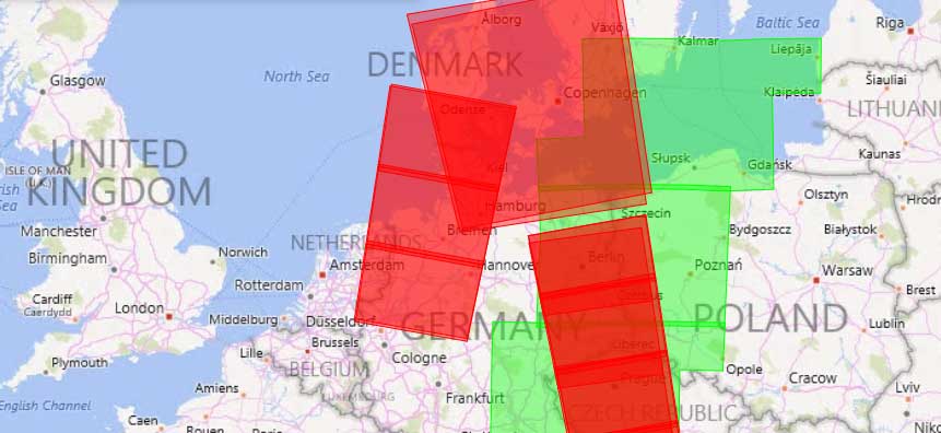
In 2014-15, Sentinel-1 and Sentinel-2A were successfully launched from Europe’s Spaceport in French Guiana.
One Sentinel scene after the other, data has been rolling out on a user interface called the Copernicus Browser.
It’s now available for the public to access. But you will have to hop through a couple of hoops before you can get your fingers on it.
To be entirely honest, it doesn’t have the best user interface. But if you follow these steps, you’ll be well on your way to download free Sentinel satellite data.
Step 1. Create a User Account
Go to Copernicus Homepage. Next, Click on the “Register” button.
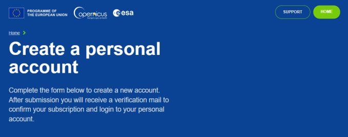
Insert valid entries for your name, email, and location. Click register. Finally, validate your email and you should be ready to go.
With a few clicks of the mouse, you’ve gained access to ESA’s Sentinel data. Let me just say that this is much more user-friendly than the Copernicus Scientific Hub.
Step 2. Zoom Into Your Area of Interest
Where is your study area? You can either do this two ways.
First, you can just manually pan and zoom all the way into your area of interest. Alternatively, you can type in where you want to go. For example, we’ve typed in Hendersonville, Tennessee. Find it in the drop-down list and the application will take you there.
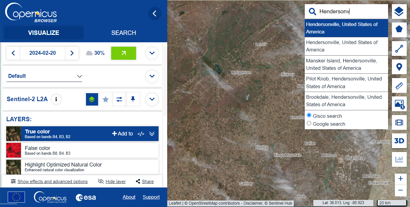
Now that you’re in the correct area of interest, it’s time to find the Sentinel imagery that you want to download.
What’s different about the Copernicus Browser is that it allows you to visualize your data before you download. It has two ribbons:
- VISUALIZE: Select your dates, cloud cover, satellite, and visualize your data in different composites.
- SEARCH: This tab is dedicated to finding the right scene and downloading the imagery as a compressed file.
Let’s go through each of these steps and find out some of their capabilities.
Step 3. Visualize Sentinel Data
We’ve already created our user account and defined our study area. Now, we can filter through some of the options available.
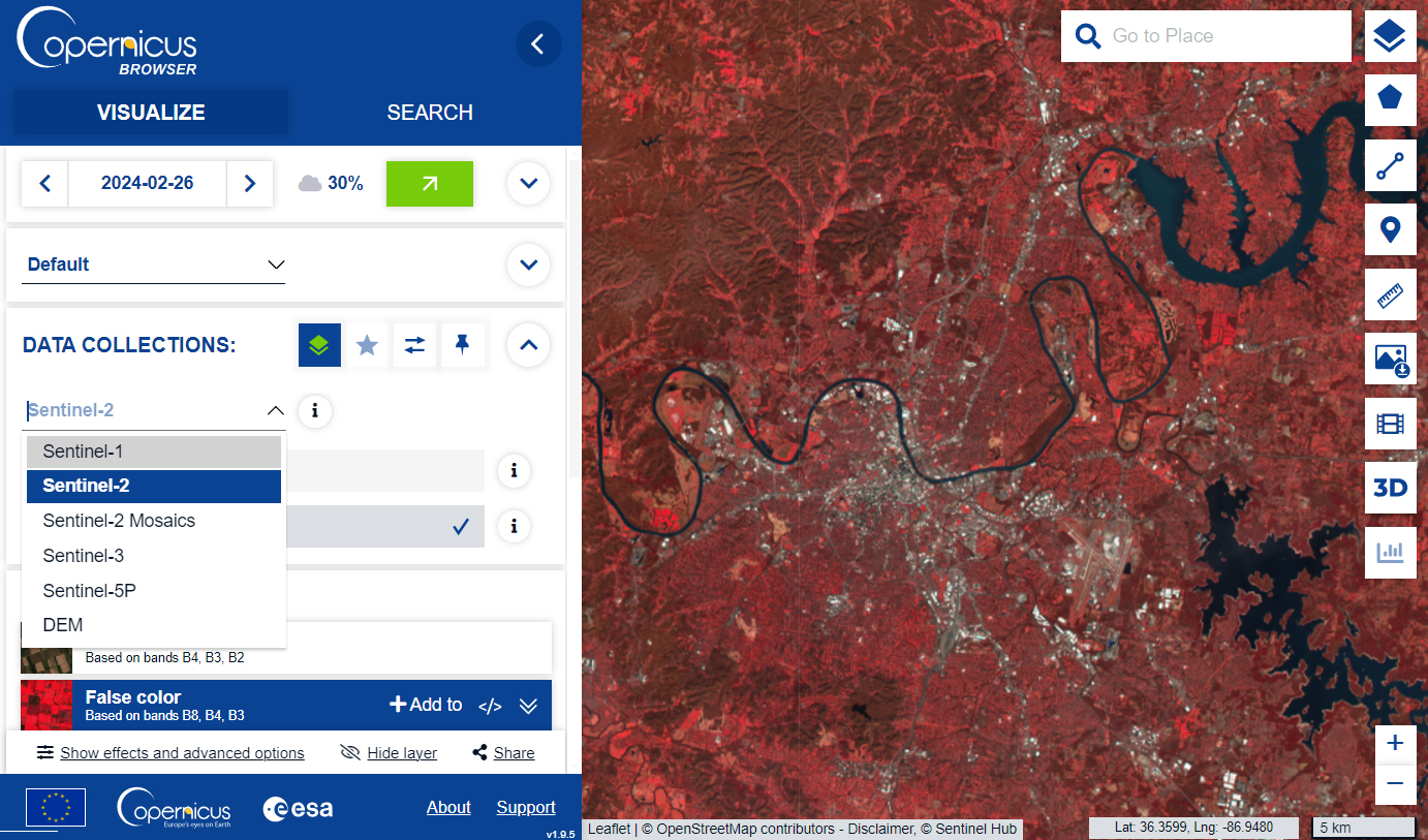
In the left panel here are some of the options available:
- Calendar – Choose the date of acquisition that you want to visualize,
- Cloud Cover – Define the maximum amount of cloud cover in the imagery.
- Configuration – Select the configuration (agriculture, geology, urban, etc.)
- Data Collection – Sentinel-1, Sentinel-2, Sentinel-3, Sentinel-5P, DEM
- Layers – True color, false color, NDVI, SWIR, land cover classification, etc.
It’s a really nice feature to be able see for yourself what the imagery will look like before you download it. This is a big improvement from the Copernicus Scientific Hub.
READ MORE: Active vs Passive Sensors
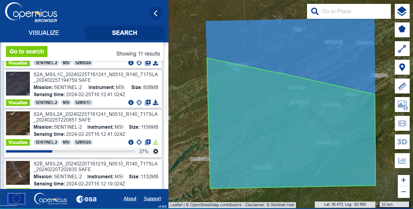
Step 4. Search Sentinel Data
Based on the criteria that you’ve entered into your visualization, you can select the product you want to download. Each product has an abbreviation. For example, S1A is Sentinel-1A and S2A is Sentinel-2A.
By clicking on the record, you will be able to see the extent of the Sentinel scene that you want to download. To download the image, all you have to do is select the “Download” button on the right.
As we are working with large data sets, you will have to be patient with download speeds. It’s easy for the server to timeout during the download. But after completion, you’ll find a SAFE.ZIP file, which you can extract.
What are the Spectral Bands of Sentinel 2A and 2B?
We’ve listed below, the spectral and spatial resolution of Sentinel 2A. There are 13 bands in Sentinel imagery. Four spectral bands have a 10-meter resolution. Six bands have a 20-meter resolution. And the remaining 3 have a spatial resolution of 60 meters.
Here are the spectral band details for Sentinel 2A and 2B:
| Band | Resolution | Central Wavelength | Description |
|---|---|---|---|
| B1 | 60 m | 443 nm | Ultra Blue (Coastal and Aerosol) |
| B2 | 10 m | 490 nm | Blue |
| B3 | 10 m | 560 nm | Green |
| B4 | 10 m | 665 nm | Red |
| B5 | 20 m | 705 nm | Visible and Near Infrared (VNIR) |
| B6 | 20 m | 740 nm | Visible and Near Infrared (VNIR) |
| B7 | 20 m | 783 nm | Visible and Near Infrared (VNIR) |
| B8 | 10 m | 842 nm | Visible and Near Infrared (VNIR) |
| B8a | 20 m | 865 nm | Visible and Near Infrared (VNIR) |
| B9 | 60 m | 940 nm | Short Wave Infrared (SWIR) |
| B10 | 60 m | 1375 nm | Short Wave Infrared (SWIR) |
| B11 | 20 m | 1610 nm | Short Wave Infrared (SWIR) |
| B12 | 20 m | 2190 nm | Short Wave Infrared (SWIR) |
Every single satellite revisit time is 10 days. Because there are two satellites (Sentinel 2A and 2B), this means it has a combined constellation revisit of 5 days.
What’s Next?
After you download Sentinel satellite data, chances are that you are going to want to display it in the visible spectrum. This is exactly how our eyes see objects around us.
Each image is separated by its respective spectral band. See our table above for the spectral bands of Sentinel 2. Remember that Sentinel 2B is identical to Sentinel 2A.
If you want to combine the red, green, and blue channels as composite bands (such as Google Earth imagery) – read our composite bands tutorial.
…Or maybe you’d like to perform an NDVI analysis in ArcGIS or image classification. You now have free satellite data from Sentinel to help you.


I’m looking to download remote turbidity data for a series of lakes in Rhode Island. Is that possible through this site?
Sorry, but we don’t have that type of data.
Hello, after finishing this content, “As we are working with large data sets, you will have to be patient with download speeds. It’s easy for the server to timeout during the download. But after completion, you’ll find a SAFE.ZIP file, which you can extract.” . How should I process the downloaded data? Do I need to use ArcMap software? Or are there any other operations and relevant videos?
We have lots of tutorials that can help you. Here are a couple of them:
https://gisgeography.com/arcgis-composite-bands/
https://gisgeography.com/remote-sensing-earth-observation-guide/
https://gisgeography.com/spectral-signature/
https://gisgeography.com/image-classification-techniques-remote-sensing/
I am new user of sentinel images. Today I tried to download the images using the step provided in the guide but instead of getting the SAFE.ZIP file it is giving me a jpeg image which is not georeferenced. Where am I going wrong? please help from some one.
You’re not downloading the correct file. It looks like you’re just downloading the quick view file. Make sure to download the largest of the files. Our instructions in this article show you how to do that.
Am a student and the maps will make it easier for me to carry out lots of assignments
Hi, the resolution of ground imagery would enhance our knowledge and help us understand ground issues. So, Sentinel made this analysis clear and accurate.
I want to have a satellite images as my website basemap, where I can get free satellite images for some zoom levels ?
Thanks
You’ve come to the right place. Basically, Sentinel-2 and Landsat are great options for smaller scale satellite imagery. When you zoom in though… the highest resolution for Sentinel is 10 meter pixels. So it might not be as crisp at the finer zoom levels
Never mind. They are now available, 30 minutes after the request.
Hi, thanks for the guide.
A question: some of the imagery are flagged as “Offline”. I add them in my cart, do you know perhaps how long does it take until they will be available for download.
Thanks
How do i find products of a specific region? The search results give no useful information about the download‘s contents.
Hi Daniel. I agree that the Sentinel-2 platform is a bit buggy.
First, zoom into your area of interest. Then, hold down the mouse with the right button to create a rectangle. This will create an area of interest and limit the available downloads of Sentinel 2 imagery.
From there, you select the “hamburger menu” in the search bar. This is how you can set filters like dates, satellite platform, product, etc.
Like so many others have said, it doesn’t matter which country or area I put in it just says “No Products Found”
It is a bit confusing to use even if you follow their guide. However, I did eventually get it to work. The 3D visual tool is really nice provided you have a pair of 3D glasses.
I was successful in getting the data and downloading but to my surprise trying to add to ArcMap is not possible. This is the message I am getting “Invalid Raster Dataset, Failed to create Raster Layer” What has gone wrong? Is it an error during downloading the datasets or what?
Like so many others have said, it doesn’t matter which country or area I put in it just says “No Products Found”
Make sure that you have the correct dates selected and one of the Sentinel satellites.
Hello, I want to estimate above-ground forest biomass using sentinel 2 imagery data and NDVI as an analysis tool. What steps should be taken to get the final biomass? Thanks
“No products found” in search for all countries
Hi, how can I download the cloud probability maps @160 m? They seem not to be present in the Copernicus package
Thanks!
Is there there any Lidar Data available? It seems most data is Spectral . . .
Here’s a link to free LiDAR data – Top 6 Free LiDAR Data Sources
No data for any country big failure
All I get when searching on the Copernicus Open Access Portal is “no products found.” I created an account, confirmed it, and I’m logged in. It says I have search and download privileges. Any ideas on what is wrong?
Is there a reason why no data is coming up regardless of what I search?
The data is crucial especially for students of developing countries
Please how can I extract bathymetric information from Sentinel-2 and which bands are used?
Thank you
^^^ SAME ^^^. Absolutely no data found regardless of what I put in (including the example ‘Germany’).
What rubbish. NO data found whatever country is input. I don’t know how these people make their way through life with such incompetent websites.
Hi, I downloaded the Sentinel data with its bands, which Band can I use to classify Bare soil, Do you have instructions on putting together a sentinel-2 composite map. Thank you
There are some tips on this page – https://gisgeography.com/spectral-signature/
There’s also the Normalized Difference Soil Index: (SWIR – NIR)/(SWIR + NIR). This is a normalized index for Landsat, but would be interesting to try for Sentinel-2.
Is there anyway to download the imagery before it has been segmented into individual tiles? ie entire swaths? I keep finding there will be one or two tiles missing from each swath.
Do you have instructions on putting together a sentinel-2 composite in PCI Geomatica as a single PIX file? The file to bring these bands in together does not work, and the workflow has slipped my mind.
Sorry, it’s been awhile since I’ve used PCI Geomatica. Maybe someone else might chime into help you out.
Hi, I want to download Radarsat-1 / SAR data of 2003. Does anyone know any free (non-commercial) source?
Once I download the Sentinel data with its bands, how to generate NDVI from the bands? Thx.
Hi Dave, here are two tutorials to help you understand Normalized Difference Vegetation Index and create NDVI maps:
https://gisgeography.com/ndvi-normalized-difference-vegetation-index/
https://gisgeography.com/how-to-ndvi-maps-arcgis/
No data for Papua New Guinea
Hi! I’m having the following problem.
I downloaded a Sentinel 2 image. I used Arcgis 10.1 to view each band, and checked that each band has the spatial resolution listed here. Then, after the composition of the bands, I get all band combinations with a 60m resolution, not 10, even when I try to use 4-3-2. Does it mean that I need to composite only the 10m resolution bands to get a 10m resolution final image? Thank you so much
I don’t know for sure but ArcGIS may default to the lowest resolution. What happens if you resample all bands to 10 meters and then try composite bands? That probably should work
After downloading the zip file and extracting. The measurement .tiff files (>500MB size) display as full pixel size, but only solid black. I’ve tried a few photo editors (Blender, PS etc) all compatible, but still show solid black screen. Is there a reason for this? Is there a work around? Thanks
Previously, Sentinel-2 files came as JPG2000, one for each spectral band. So if you wanted to view a scene in natural color (RGB), you would have to perform ‘composite bands’. You can do this in qgis.org or in ArcGIS.
Generally, you can’t view these raw files in Photoshop because they are georeferenced. That means a TIF file would have world file (TFW). And I believe, Adobe Photoshop doesn’t know how to handle these files.
So after performing ‘composite bands’, try exporting it to different formats that Adobe Photoshop can open. For example, exporting it to PDF format would suffice as Photoshop can open this file format.
Hope this helps
I want to download the Sentinel 3 data, but on scihub.copernicus.eu it seems that they didn’t have Sentinel-3 data. Where can I find it ? Thanks..
You can download Sentinel-3 data here – https://scihub.copernicus.eu/
Using QGIS, images can be downloaded directly in your map with the semi-automatic classification plug-in.
I found that dragging an outline around an area on their display map revealed the swathpaths that I was after. Works like a treat.
There seems to be no data for Africa. Is this a spoof?
99% chance of not downloading properly. Download appears to be complete, but file is incomplete. This is after resuming downloads etc. More trouble shooting instructions would have been useful, as I expect you would have experienced the problems I have, but have chosen to gloss over HOW PROBLEMATIC the download is/can be.
Sorry to hear that. I haven’t had this issue at all. You can also download Sentinel-2 data from USGS Earth Explorer, which should work 100% of the time
No data for North America I can find. But got L1 from https://earthexplorer.usgs.gov/
No data for the UK
They removed the sign up button. :(
It looks like it’s still there when I go to the page. You can also download Sentinel 2 data from USGS Earth Explorer – https://earthexplorer.usgs.gov/
Please note that the Copernicus Programme belongs to the European Union and not the European Space Agency.