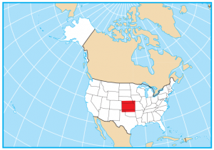
Kansas County Map

About the map
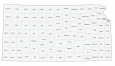
This Kansas county map displays its 105 counties. Its count of 105 counties gives it the fifth highest of any other state. Only Texas, Georgia, Virginia, Kentucky, and Missouri have more counties than the state of Kansas.
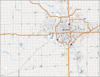
The second most populous county in Kansas is Sedgwick County because it contains the city of Wichita. But overall, it’s Johnson County that has the highest population because it is a suburb of Kansas City, and it has Overland Park.
For size, Butler County is the largest which is located in the southeast portion of Kansas. The smallest county in Kansas is Wyandotte County, which borders its neighboring state of Missouri, near Kansas City.
You are free to use our county map of Kansas for educational and commercial uses. Attribution is required. How to attribute?
Kansas county list
| FIPS Code | Name | Land (sq mi) | Water (sq mi) | Population (2024) |
|---|---|---|---|---|
| 20-001 | Allen County | 500.3 | 5.0 | 12,425 |
| 20-003 | Anderson County | 579.6 | 4.1 | 7,908 |
| 20-005 | Atchison County | 431.2 | 2.6 | 16,249 |
| 20-007 | Barber County | 1134.1 | 2.1 | 4,070 |
| 20-009 | Barton County | 895.3 | 5.4 | 24,835 |
| 20-011 | Bourbon County | 635.5 | 3.6 | 14,424 |
| 20-013 | Brown County | 570.9 | 1.2 | 9,142 |
| 20-015 | Butler County | 1429.7 | 16.9 | 69,158 |
| 20-017 | Chase County | 773.1 | 4.7 | 2,507 |
| 20-019 | Chautauqua County | 638.9 | 5.9 | 3,339 |
| 20-021 | Cherokee County | 587.6 | 3.5 | 19,133 |
| 20-023 | Cheyenne County | 1019.9 | 1.1 | 2,646 |
| 20-025 | Clark County | 974.6 | 2.5 | 1,873 |
| 20-027 | Clay County | 645.3 | 10.3 | 7,969 |
| 20-029 | Cloud County | 715.3 | 2.6 | 8,723 |
| 20-031 | Coffey County | 626.9 | 27.2 | 8,301 |
| 20-033 | Comanche County | 788.3 | 1.4 | 1,694 |
| 20-035 | Cowley County | 1125.7 | 6.7 | 34,186 |
| 20-037 | Crawford County | 589.8 | 5.2 | 38,904 |
| 20-039 | Decatur County | 893.5 | 0.6 | 2,716 |
| 20-041 | Dickinson County | 847.1 | 4.9 | 18,621 |
| 20-043 | Doniphan County | 393.5 | 4.8 | 7,575 |
| 20-045 | Douglas County | 455.8 | 18.9 | 121,989 |
| 20-047 | Edwards County | 621.9 | 0.1 | 2,731 |
| 20-049 | Elk County | 644.3 | 6.2 | 2,436 |
| 20-051 | Ellis County | 899.9 | 0.5 | 29,007 |
| 20-053 | Ellsworth County | 715.6 | 7.7 | 6,316 |
| 20-055 | Finney County | 1302.0 | 0.7 | 38,354 |
| 20-057 | Ford County | 1098.3 | 0.8 | 34,072 |
| 20-059 | Franklin County | 571.8 | 5.4 | 26,273 |
| 20-061 | Geary County | 384.7 | 19.9 | 35,459 |
| 20-063 | Gove County | 1071.7 | 0.1 | 2,658 |
| 20-065 | Graham County | 898.5 | 0.2 | 2,370 |
| 20-067 | Grant County | 574.8 | 0.3 | 7,097 |
| 20-069 | Gray County | 868.9 | 0.4 | 5,730 |
| 20-071 | Greeley County | 778.4 | 0.0 | 1,152 |
| 20-073 | Greenwood County | 1143.3 | 9.3 | 5,871 |
| 20-075 | Hamilton County | 996.5 | 1.1 | 2,488 |
| 20-077 | Harper County | 801.3 | 1.5 | 5,413 |
| 20-079 | Harvey County | 539.8 | 1.0 | 33,642 |
| 20-081 | Haskell County | 577.5 | 0.4 | 3,591 |
| 20-083 | Hodgeman County | 860.0 | 0.3 | 1,673 |
| 20-085 | Jackson County | 656.2 | 1.8 | 13,525 |
| 20-087 | Jefferson County | 532.6 | 24.1 | 18,332 |
| 20-089 | Jewell County | 910.0 | 4.4 | 2,899 |
| 20-091 | Johnson County | 473.6 | 6.3 | 632,276 |
| 20-093 | Kearny County | 870.5 | 0.4 | 3,808 |
| 20-095 | Kingman County | 863.4 | 3.3 | 6,946 |
| 20-097 | Kiowa County | 722.6 | 0.2 | 2,436 |
| 20-099 | Labette County | 645.4 | 7.7 | 19,692 |
| 20-101 | Lane County | 717.4 | 0.2 | 1,482 |
| 20-103 | Leavenworth County | 463.4 | 5.5 | 84,670 |
| 20-105 | Lincoln County | 719.4 | 1.1 | 2,928 |
| 20-107 | Linn County | 594.1 | 12.3 | 9,841 |
| 20-109 | Logan County | 1073.0 | 0.1 | 2,694 |
| 20-111 | Lyon County | 847.5 | 7.9 | 32,520 |
| 20-113 | McPherson County | 898.3 | 2.3 | 30,334 |
| 20-115 | Marion County | 944.3 | 9.4 | 11,670 |
| 20-117 | Marshall County | 900.2 | 4.9 | 9,950 |
| 20-119 | Meade County | 978.1 | 1.3 | 3,892 |
| 20-121 | Miami County | 575.9 | 14.4 | 35,737 |
| 20-123 | Mitchell County | 701.8 | 17.4 | 5,803 |
| 20-125 | Montgomery County | 643.6 | 7.9 | 30,459 |
| 20-127 | Morris County | 695.3 | 7.5 | 5,279 |
| 20-129 | Morton County | 729.7 | 0.2 | 2,485 |
| 20-131 | Nemaha County | 717.4 | 2.0 | 10,062 |
| 20-133 | Neosho County | 571.5 | 6.3 | 15,552 |
| 20-135 | Ness County | 1074.7 | 0.3 | 2,617 |
| 20-137 | Norton County | 878.0 | 3.3 | 5,335 |
| 20-139 | Osage County | 705.5 | 14.3 | 15,737 |
| 20-141 | Osborne County | 892.5 | 1.9 | 3,353 |
| 20-143 | Ottawa County | 720.7 | 0.6 | 5,853 |
| 20-145 | Pawnee County | 754.3 | 0.4 | 6,012 |
| 20-147 | Phillips County | 885.9 | 8.7 | 4,733 |
| 20-149 | Pottawatomie County | 840.8 | 20.9 | 26,876 |
| 20-151 | Pratt County | 735.0 | 0.7 | 9,137 |
| 20-153 | Rawlins County | 1069.4 | 0.2 | 2,432 |
| 20-155 | Reno County | 1255.5 | 16.6 | 61,417 |
| 20-157 | Republic County | 717.4 | 3.1 | 4,613 |
| 20-159 | Rice County | 726.2 | 1.7 | 9,284 |
| 20-161 | Riley County | 609.7 | 12.3 | 72,557 |
| 20-163 | Rooks County | 890.5 | 4.6 | 4,748 |
| 20-165 | Rush County | 717.8 | 0.2 | 2,810 |
| 20-167 | Russell County | 886.3 | 13.2 | 6,620 |
| 20-169 | Saline County | 720.2 | 1.1 | 53,459 |
| 20-171 | Scott County | 717.6 | 0.1 | 4,914 |
| 20-173 | Sedgwick County | 997.5 | 11.6 | 536,081 |
| 20-175 | Seward County | 639.6 | 0.8 | 21,276 |
| 20-177 | Shawnee County | 544.0 | 11.7 | 177,942 |
| 20-179 | Sheridan County | 896.0 | 0.2 | 2,397 |
| 20-181 | Sherman County | 1056.1 | 0.2 | 5,796 |
| 20-183 | Smith County | 895.5 | 1.5 | 3,541 |
| 20-185 | Stafford County | 792.0 | 2.9 | 3,901 |
| 20-187 | Stanton County | 680.3 | 0.1 | 2,071 |
| 20-189 | Stevens County | 727.3 | 0.2 | 5,035 |
| 20-191 | Sumner County | 1181.6 | 3.3 | 22,336 |
| 20-193 | Thomas County | 1074.7 | 0.1 | 7,802 |
| 20-195 | Trego County | 889.5 | 10.1 | 2,774 |
| 20-197 | Wabaunsee County | 794.3 | 5.3 | 7,112 |
| 20-199 | Wallace County | 913.6 | 0.1 | 1,472 |
| 20-201 | Washington County | 894.8 | 3.9 | 5,572 |
| 20-203 | Wichita County | 718.6 | 0.0 | 2,072 |
| 20-205 | Wilson County | 570.4 | 4.7 | 8,398 |
| 20-207 | Woodson County | 497.8 | 7.4 | 3,111 |
| 20-209 | Wyandotte County | 151.6 | 4.6 | 169,418 |