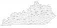
Kentucky County Map

About the map
This Kentucky county map displays its extensive 120 counties. In fact, its number of counties represents the fourth most in the United States. Only Texas, Georgia, and Virginia have more counties and administrative units than Kentucky.
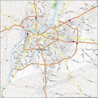
Jefferson County is the most populated county in Kentucky, which includes the major city of Louisville. Next, Fayette, Kenton, and Boone counties have the highest population. But the least populated is Robertson County with just over 2,000 people.
In terms of area, Pike County is the largest occupying an area of 785.7 square miles, bordering both states of Virginia and West Virginia. Robertson County is not only the least population. But it’s also the smallest occupying just 100.3 square miles.

You are free to use our county map of Kentucky for educational and commercial uses. Attribution is required. How to attribute?
Kentucky county list
| FIPS Code | Name | Land (sq mi) | Water (sq mi) | Population (2024) |
|---|---|---|---|---|
| 21-001 | Adair County | 405.3 | 7.1 | 19,239 |
| 21-003 | Allen County | 344.3 | 7.5 | 22,037 |
| 21-005 | Anderson County | 202.1 | 2.2 | 24,883 |
| 21-007 | Ballard County | 246.9 | 26.8 | 7,626 |
| 21-009 | Barren County | 487.6 | 12.4 | 45,609 |
| 21-011 | Bath County | 278.8 | 5.2 | 12,951 |
| 21-013 | Bell County | 359.1 | 2.1 | 23,051 |
| 21-015 | Boone County | 246.3 | 10.2 | 144,135 |
| 21-017 | Bourbon County | 289.7 | 1.9 | 20,333 |
| 21-019 | Boyd County | 159.9 | 2.2 | 47,777 |
| 21-021 | Boyle County | 180.3 | 2.5 | 31,394 |
| 21-023 | Bracken County | 202.7 | 6.2 | 8,497 |
| 21-025 | Breathitt County | 492.4 | 2.9 | 12,804 |
| 21-027 | Breckinridge County | 569.8 | 15.8 | 21,221 |
| 21-029 | Bullitt County | 297.0 | 3.2 | 85,802 |
| 21-031 | Butler County | 426.1 | 5.4 | 12,551 |
| 21-033 | Caldwell County | 344.8 | 3.4 | 12,611 |
| 21-035 | Calloway County | 385.0 | 25.7 | 38,975 |
| 21-037 | Campbell County | 151.3 | 8.1 | 94,008 |
| 21-039 | Carlisle County | 189.4 | 9.5 | 4,777 |
| 21-041 | Carroll County | 128.6 | 8.7 | 11,111 |
| 21-043 | Carter County | 409.5 | 2.6 | 26,098 |
| 21-045 | Casey County | 444.2 | 1.5 | 15,948 |
| 21-047 | Christian County | 717.5 | 6.5 | 71,006 |
| 21-049 | Clark County | 252.5 | 2.7 | 37,673 |
| 21-051 | Clay County | 469.3 | 1.8 | 19,592 |
| 21-053 | Clinton County | 197.2 | 8.2 | 9,183 |
| 21-055 | Crittenden County | 360.0 | 11.2 | 8,982 |
| 21-057 | Cumberland County | 305.2 | 5.7 | 6,047 |
| 21-059 | Daviess County | 458.4 | 18.2 | 104,457 |
| 21-061 | Edmonson County | 302.9 | 5.1 | 12,635 |
| 21-063 | Elliott County | 234.3 | 1.0 | 7,263 |
| 21-065 | Estill County | 253.1 | 2.5 | 14,002 |
| 21-067 | Fayette County | 283.6 | 1.9 | 329,437 |
| 21-069 | Fleming County | 348.5 | 2.8 | 15,591 |
| 21-071 | Floyd County | 393.3 | 2.4 | 34,532 |
| 21-073 | Franklin County | 207.8 | 4.2 | 52,442 |
| 21-075 | Fulton County | 205.9 | 24.7 | 6,282 |
| 21-077 | Gallatin County | 98.3 | 6.4 | 8,805 |
| 21-079 | Garrard County | 230.1 | 3.8 | 18,040 |
| 21-081 | Grant County | 258.0 | 2.8 | 25,722 |
| 21-083 | Graves County | 551.8 | 5.0 | 36,821 |
| 21-085 | Grayson County | 499.9 | 11.1 | 27,070 |
| 21-087 | Green County | 286.0 | 2.7 | 11,552 |
| 21-089 | Greenup County | 344.5 | 10.0 | 35,273 |
| 21-091 | Hancock County | 187.7 | 11.2 | 9,013 |
| 21-093 | Hardin County | 623.4 | 6.7 | 112,826 |
| 21-095 | Harlan County | 465.8 | 2.3 | 25,052 |
| 21-097 | Harrison County | 306.4 | 3.5 | 19,525 |
| 21-099 | Hart County | 412.6 | 5.3 | 19,923 |
| 21-101 | Henderson County | 436.5 | 29.5 | 44,175 |
| 21-103 | Henry County | 286.3 | 4.8 | 16,198 |
| 21-105 | Hickman County | 242.3 | 10.8 | 4,393 |
| 21-107 | Hopkins County | 542.1 | 12.3 | 45,218 |
| 21-109 | Jackson County | 345.2 | 1.3 | 13,358 |
| 21-111 | Jefferson County | 380.7 | 17.0 | 793,881 |
| 21-113 | Jessamine County | 172.2 | 2.4 | 56,495 |
| 21-115 | Johnson County | 262.0 | 2.2 | 22,098 |
| 21-117 | Kenton County | 160.3 | 4.0 | 174,862 |
| 21-119 | Knott County | 351.5 | 1.3 | 13,438 |
| 21-121 | Knox County | 386.3 | 1.4 | 29,657 |
| 21-123 | Larue County | 261.6 | 2.1 | 15,128 |
| 21-125 | Laurel County | 434.0 | 9.7 | 63,353 |
| 21-127 | Lawrence County | 415.6 | 4.5 | 15,798 |
| 21-129 | Lee County | 208.9 | 2.4 | 7,313 |
| 21-131 | Leslie County | 400.9 | 3.5 | 9,729 |
| 21-133 | Letcher County | 337.9 | 1.1 | 20,139 |
| 21-135 | Lewis County | 482.8 | 12.5 | 12,875 |
| 21-137 | Lincoln County | 332.8 | 3.5 | 24,910 |
| 21-139 | Livingston County | 313.1 | 29.2 | 8,815 |
| 21-141 | Logan County | 552.2 | 4.8 | 28,467 |
| 21-143 | Lyon County | 213.8 | 42.7 | 9,078 |
| 21-145 | McCracken County | 248.7 | 19.4 | 67,550 |
| 21-147 | McCreary County | 426.8 | 4.1 | 16,824 |
| 21-149 | McLean County | 252.5 | 3.7 | 9,126 |
| 21-151 | Madison County | 437.3 | 5.9 | 99,582 |
| 21-153 | Magoffin County | 308.4 | 0.7 | 11,118 |
| 21-155 | Marion County | 343.0 | 3.8 | 19,851 |
| 21-157 | Marshall County | 301.3 | 38.9 | 31,734 |
| 21-159 | Martin County | 229.6 | 1.0 | 10,696 |
| 21-161 | Mason County | 240.1 | 6.3 | 16,956 |
| 21-163 | Meade County | 305.4 | 19.1 | 30,442 |
| 21-165 | Menifee County | 203.6 | 2.3 | 6,341 |
| 21-167 | Mercer County | 249.1 | 4.2 | 23,515 |
| 21-169 | Metcalfe County | 289.6 | 1.5 | 10,558 |
| 21-171 | Monroe County | 329.4 | 2.6 | 11,163 |
| 21-173 | Montgomery County | 197.3 | 1.5 | 28,771 |
| 21-175 | Morgan County | 381.1 | 2.7 | 14,300 |
| 21-177 | Muhlenberg County | 467.4 | 12.0 | 30,512 |
| 21-179 | Nelson County | 417.5 | 6.6 | 48,706 |
| 21-181 | Nicholas County | 195.2 | 1.7 | 7,816 |
| 21-183 | Ohio County | 587.3 | 8.9 | 23,933 |
| 21-185 | Oldham County | 187.2 | 9.2 | 70,525 |
| 21-187 | Owen County | 351.1 | 3.1 | 11,435 |
| 21-189 | Owsley County | 197.4 | 0.9 | 3,928 |
| 21-191 | Pendleton County | 277.2 | 4.8 | 14,844 |
| 21-193 | Perry County | 339.7 | 2.9 | 26,739 |
| 21-195 | Pike County | 786.7 | 1.8 | 55,430 |
| 21-197 | Powell County | 179.0 | 1.1 | 12,928 |
| 21-199 | Pulaski County | 658.4 | 18.7 | 66,842 |
| 21-201 | Robertson County | 99.9 | 0.2 | 2,382 |
| 21-203 | Rockcastle County | 316.5 | 1.5 | 16,226 |
| 21-205 | Rowan County | 279.8 | 6.4 | 24,675 |
| 21-207 | Russell County | 253.7 | 29.2 | 18,458 |
| 21-209 | Scott County | 281.8 | 3.6 | 61,700 |
| 21-211 | Shelby County | 379.8 | 5.9 | 50,124 |
| 21-213 | Simpson County | 234.2 | 2.3 | 20,350 |
| 21-215 | Spencer County | 186.7 | 4.9 | 20,823 |
| 21-217 | Taylor County | 266.4 | 10.5 | 26,809 |
| 21-219 | Todd County | 374.5 | 2.6 | 12,757 |
| 21-221 | Trigg County | 441.6 | 39.8 | 14,559 |
| 21-223 | Trimble County | 151.6 | 4.6 | 8,591 |
| 21-225 | Union County | 342.9 | 20.5 | 13,178 |
| 21-227 | Warren County | 541.7 | 5.8 | 147,936 |
| 21-229 | Washington County | 297.0 | 4.2 | 12,269 |
| 21-231 | Wayne County | 458.2 | 26.0 | 19,629 |
| 21-233 | Webster County | 332.1 | 3.6 | 12,854 |
| 21-235 | Whitley County | 437.8 | 7.3 | 37,233 |
| 21-237 | Wolfe County | 222.2 | 0.6 | 6,364 |
| 21-239 | Woodford County | 190.1 | 1.9 | 27,728 |