Landsat 9: A Legacy of Earth Observation
Landsat 9: A Brief Overview
The Landsat program is the longest-running Earth observatory program with over 50 years of continuous remote sensing observations of our planet.
In order to continue its long-standing legacy, NASA and the USGS launched Landsat-9 in September 2021 as the ninth satellite as part of this program.
From monitoring crops to tracking deforestation, the Landsat program has been a key driver in meeting the growing demand for data that decision-makers need to understand our changing planet.
This article will take you through a brief overview of the Landsat-9 satellite. What are its spectral bands? And how is it different from Landsat-8?
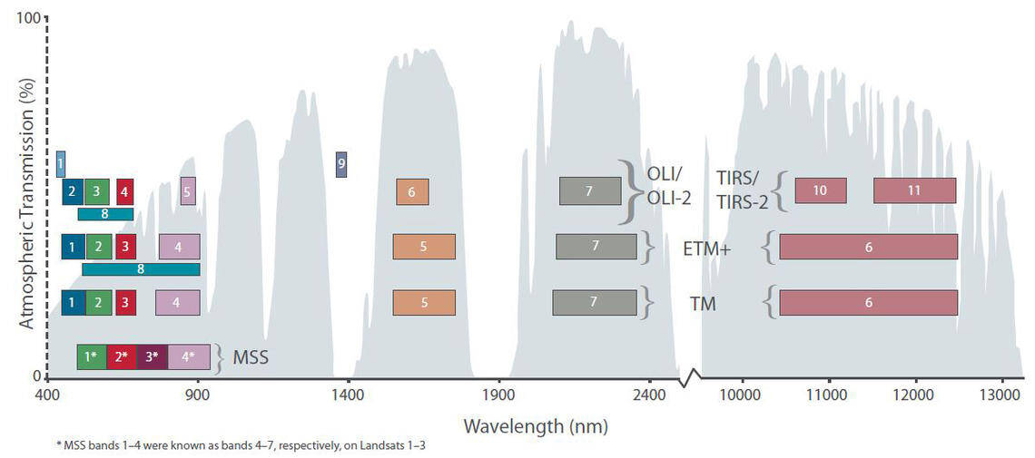
Landsat-9 Band Designations
From a band designation perspective, you can consider the instruments on Landsat 9 as a copy of Landsat 8. However, there are some improvements in radiometric resolution as described below.
| Band Number | Description | Wavelength | Resolution |
| Band 1 | Coastal / Aerosol | 0.433 to 0.453 µm | 30 meter |
| Band 2 | Visible blue | 0.450 to 0.515 µm | 30 meter |
| Band 3 | Visible green | 0.525 to 0.600 µm | 30 meter |
| Band 4 | Visible red | 0.630 to 0.680 µm | 30 meter |
| Band 5 | Near-infrared | 0.845 to 0.885 µm | 30 meter |
| Band 6 | Short wavelength infrared | 1.56 to 1.66 µm | 30 meter |
| Band 7 | Short wavelength infrared | 2.10 to 2.30 µm | 60 meter |
| Band 8 | Panchromatic | 0.50 to 0.68 µm | 15 meter |
| Band 9 | Cirrus | 1.36 to 1.39 µm | 30 meter |
| Band 10 | Long wavelength infrared | 10.3 to 11.3 µm | 100 meter |
| Band 11 | Long wavelength infrared | 11.5 to 12.5 µm | 100 meter |
Differences From Landsat-8
One of the major differences between Landsat-9 and its predecessors is an improvement in radiometric resolution for the Operational Land Imager 2 (OLI-2).
Previously, Landsat-8’s 12-bit resolution could differentiate between 4,096 shades of a given wavelength (and just 256 shades for Landsat-7). But Landsat-9’s 14-bit resolution provides 16,384 shades, which is a significant improvement.
The other major difference is an improvement in the thermal infrared sensor (TIRS-2). Because TIRS-2 can reduce the amount of stray light, this improves atmospheric correction and in turn, gives better readings for surface temperature.
Download Landsat-9 Imagery
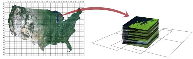
Every day, Landsat-9 orbits the Earth 14 times and captures approximately 700+ images per day. With a near-polar orbit, Landsat-9 alone obtains coverage of our planet every 16 days. But if you include the tandem of both Landsat-9 with Landsat-8 working together, they can achieve global coverage in just 8 days.
One of the bright spots about the entire Landsat program (and Sentinel 2 imagery) is that it’s completely open to the public to download. Here are some of the most reliable providers for accessing Landsat-9 data.
USGS EarthExplorer – First, make sure to check out this guide on how to download Landsat data to quickly get started. You will be able to find Landsat-9 imagery under the “Landsat” products in the datasets tab. There are options for Level-1, Level-2, and Analysis Ready Data.
Machine to Machine (M2M) – This API is a JSON-based REST API where you can make requests with download URLs to the Landsat inventories. The download options are the same as the USGS Earth Explorer, but M2M uses the REST API for retrieving data.
Quick Facts
There’s a lot to know about Landsat-9 so here are some quick facts to find out more about its orbit, altitude, and more.
- Operational Land Imager 2 (OLI-2): 9 spectral bands as Band 1 to 9 (15m, 30m, and 60m)
- Thermal Infrared Sensor 2 (TIRS-2): 2 thermal bands as Band 10 and 11 (100m spatial resolution)
- Radiometric Resolution: 14-bit
- Launch Date: September 27, 2021
- Launch Location: Vandenberg Air Force Base in California
- Altitude: 438 miles (705 kilometers)
- Orbit Duration: 99 minutes
- Orbits per Day: 14
- Design Life: 5 Years
- Images per Day: 700+
- Coverage of Earth: Every 16 days
Plus, here is the Landsat file naming convention if you want to know how the scene identifiers organize each Landsat image.
What’s Next?
The Landsat program has been an essential tool in studying the Earth from space for over four decades.
It supports a wide range of applications and services, including monitoring the state of the environment, improving crop management, and tracking natural hazards.
The Landsat-9 satellite is the latest in the series, having launched in late 2021 to continue its legacy as the longest Earth observation program in history.
Remember if you want to learn more applications and use cases for Landsat, don’t forget to read our 100 remote sensing applications and uses with more exciting opportunities.


