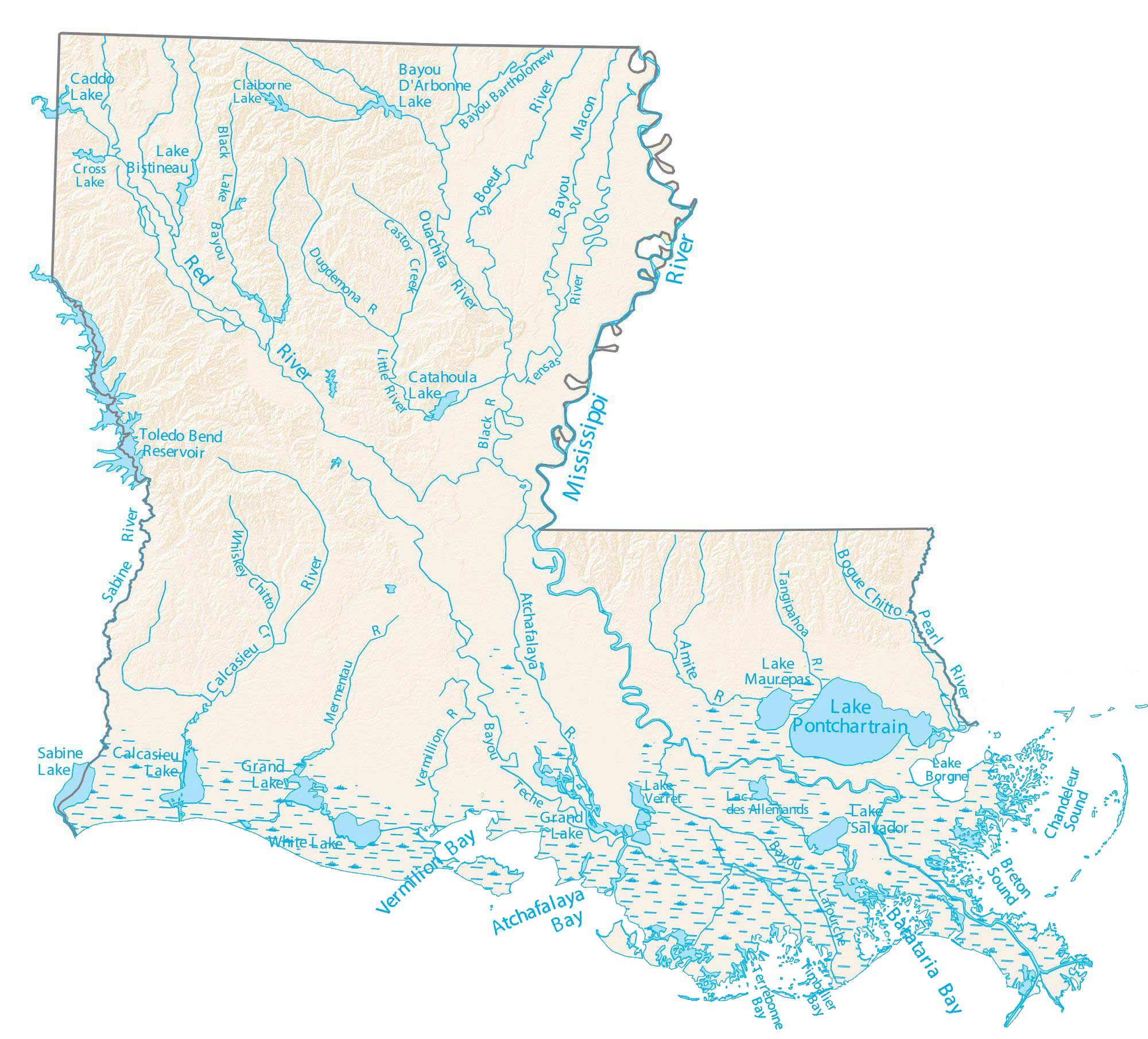
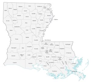
Louisiana Lakes and Rivers Map
About the map
This map displays major bays, sounds, and lakes of Louisiana like Lake Pontchartrain. It also shows major rivers, including the Red, Atchafalaya, and Sabine Rivers, along with bayous and wetlands.
Two rivers on the east side of Louisiana carve out the border with its neighboring states. It’s the Mississippi River and Pearl River that shares a border with Mississippi. But on the west side, it’s the Sabine River sharing a border with the state of Texas.
Lake Pontchartrain is the largest lake in Louisiana at over 400,000 acres in size. In fact, it more than doubles the next largest, the Toledo Bend Reservoir, which shares a boundary with the state of Texas. Finally, Caddo Lake and Bayou D’Arbonne Lake are the next largest lakes, both larger than 15,000 acres in area.
Louisiana map collection


You are free to use our lakes and rivers map of Louisiana for educational and commercial uses. Attribution is required. How to attribute?
Louisiana lakes, rivers and reservoirs
Lakes and reservoirs
Sabine Lake
Lake Pontchartrain
Calcasieu Lake
Lake Grand
White Lake
Lake D’Arbonne
Catahoula Lake
Lake Maurepas
Grand Lake
Lake Salvador
Caddo Lake
Lake Bistineau
Lac des Allemands
Cross Lake
Claiborne Lake
Lake Borgne
Lake Verret
Toledo Bend Reservoir
Rivers and streams
Mississippi River
Red River
Pearl River
Ouachita River
Boeuf River
Calcasieu River
Atchafalaya River
Amite River
Bogue Chitto River
Tensas River
Black River
Tangipahoa River
Vermillion River
Mermentau River
Dugdemona River
Little River
Whiskey Chitto Creek
Castor Creek
Bays and sounds
Atchafalaya Bay
Vermilion Bay
Barataria Bay
Terrebonne Bay
Chandeleur Sound
Timbalier Bay
Breton Sound
Bayou
Bayou Macon
Bayou Bartholomew
Bayou Lafourche
Teche Bayou
Black Lake Bayou
The Natalbany River starts just north of La16 west of Amite and travels south. The river flows west of and parallel to Interstate 55. It eventually flows into a larger river just North of Lake Maurepas. I hope this helps you. Martha M.
I have a problem, my best friend and I, as teenagers, were brought by her dad to go water ski-ing every summer and I was just learning how so he would bring us down the Natalbany River since it was so smooth and perfect to slollium(ski on one ski, I am so sorry for the spelling). I can’t find on a Louisiana Waterways Map where the Natalbany River is, could you please help me to locate this River and possibly point it out on a map? We went down the Blind River to get to it but ai dont see the Blind River listed either. Please HELP Sincerely, Kristina Holcombe