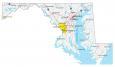
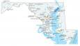
Maryland County Map and Independent City

About the map
This Maryland county map displays its 23 counties and one independent city. Maryland (along with Missouri, Nevada, and Virginia) also has independent cities, and government units outside the jurisdiction of any county.
Montgomery County has the highest population in Maryland and is adjacent to the District of Columbia. Prince George’s and Baltimore County are other populated counties in Maryland. Conversely, Kent County has the lowest population with less than 20,000 people.
For size, Frederick County is the largest occupying 667.7 square miles of area. If you include Baltimore City, it’s just 81.4 square miles. Then, Calvert County is the next smallest area along the Chesapeake Bay.
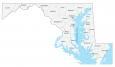
You are free to use our county map of Maryland for educational and commercial uses. Attribution is required. How to attribute?
Maryland county list
| FIPS Code | Name | Land (sq mi) | Water (sq mi) | Population (2024) |
|---|---|---|---|---|
| 24-001 | Allegany County | 422.2 | 5.7 | 67,097 |
| 24-003 | Anne Arundel County | 414.8 | 173.0 | 602,350 |
| 24-005 | Baltimore County | 598.4 | 83.4 | 852,425 |
| 24-009 | Calvert County | 213.2 | 131.9 | 94,913 |
| 24-011 | Caroline County | 319.4 | 6.5 | 34,248 |
| 24-013 | Carroll County | 447.6 | 5.1 | 177,108 |
| 24-015 | Cecil County | 346.3 | 71.6 | 106,305 |
| 24-017 | Charles County | 457.8 | 185.1 | 174,478 |
| 24-019 | Dorchester County | 540.8 | 442.2 | 33,138 |
| 24-021 | Frederick County | 660.5 | 6.9 | 299,317 |
| 24-023 | Garrett County | 649.1 | 8.7 | 28,393 |
| 24-025 | Harford County | 437.1 | 89.5 | 265,514 |
| 24-027 | Howard County | 250.9 | 2.4 | 339,668 |
| 24-029 | Kent County | 277.0 | 136.4 | 19,557 |
| 24-031 | Montgomery County | 493.1 | 13.8 | 1,082,273 |
| 24-033 | Prince George’s County | 482.6 | 16.2 | 966,629 |
| 24-035 | Queen Anne’s County | 371.7 | 139.0 | 53,688 |
| 24-037 | St. Mary’s County | 358.7 | 405.6 | 116,469 |
| 24-039 | Somerset County | 319.7 | 290.6 | 25,241 |
| 24-041 | Talbot County | 268.6 | 208.2 | 38,244 |
| 24-043 | Washington County | 457.8 | 9.6 | 157,228 |
| 24-045 | Wicomico County | 374.4 | 25.8 | 106,329 |
| 24-047 | Worcester County | 468.3 | 226.6 | 54,337 |
| 24-510 | Baltimore Independent City | 80.9 | 11.1 | 568,271 |