NAD27 – Meade’s Ranch at the Center of It All
The North American Datum of 1927
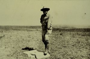
A long time ago, surveyors inserted brass monuments into the Earth known as survey benchmarks.
Using a technique called triangulation, monuments were mathematically connected into a horizontal datum.
But the old North American Datum 27 (NAD27) was centered at Meade’s Ranch, the heart of the United States.
…And well now, what can you say is we’re not in Kansas anymore.
A Massive Collection of Survey Benchmarks
Over the past two centuries, surveyors measured extremely precise locations on the Earth’s surface.
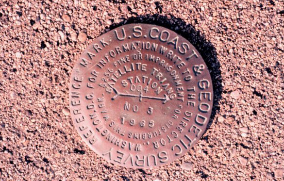

These survey benchmark locations are brass or aluminum disks in the ground. Each one has a unique identifier that we can reference.
NAD27 Centered at Meade’s Ranch, Kansas
We reference all coordinates on Earth using a horizontal datum. Thanks to our frame of reference, specify points on Earth like the one you are on now. A horizontal datum (like NAD27) is a model that translates an ellipsoid into latitude and longitude coordinates.
NAD27 put a fixed latitude and longitude position at Meade’s Ranch, Kansas (39° 13’26.686″ north latitude, 98° 32’30.506″ west longitude). This was because it was near the center of the contiguous United States.
After that, all points in North America used the Meade’s Ranch survey monument as a reference for measuring direction and distance away from it. Even today, most historical USGS topographic maps and projects by the US Army Corps of Engineers are based on this reference system.
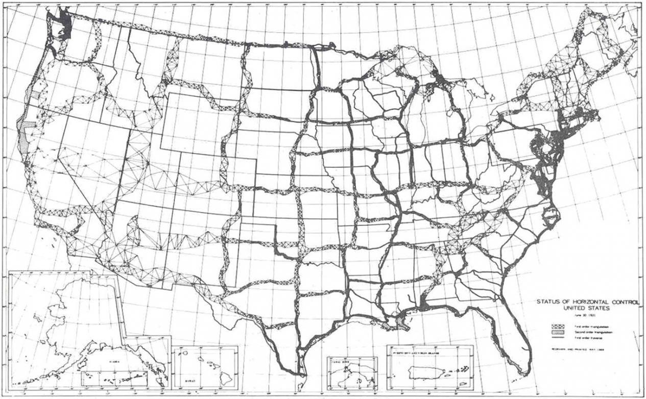
First-Order Triangulation
The North American Datum of 1927 is the adjustment of long-baseline surveys to establish a network of standardized horizontal positions in North America. First-order triangulation was used to connect horizontal monuments into a unified network. All latitudes and longitudes could be measured on the Clarke Ellipsoid of 1866.
Approximately 26,000 survey stations were gathered in the United States and Canada. NOAA’s National Geodetic Survey used these survey stations and triangulation to form the NAD27 datum.
BUT the network of points in 1927 was sparse in comparison.
As time went on, surveyors benchmarked approximately 250,000 stations. This set of horizontal positions formed the basis for the North American Datum of 1983 (NAD83). In 1983, the NAD27 datum was eventually replaced with NAD83.
Geodetic Datums: NAD83 versus NAD27
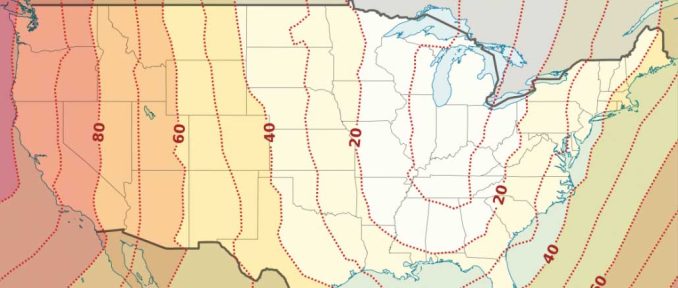
In 1983, NAD83 replaced NAD27 because of its inaccuracies. NAD83 corrects some of the distortions from NAD27 over distance. It does this by using a more dense set of positions from terrestrial and Doppler satellite data. Approximately 250,000 stations were used to develop the NAD83 datum. This compares to only 26,000 used in the NAD27 datum.
According to NOAA, the geographic coordinates in NAD27 datum might be hundreds of meters different from a NAD83 datum. The average correction between NAD27 and NAD84 is an average of 0.349″ northward and 1.822″ eastward.
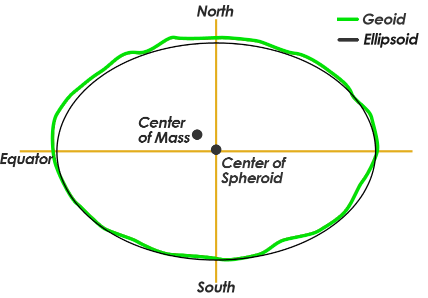
One of the main differences is that NAD83 uses an Earth-centered reference, rather than a fixed station in NAD27. All coordinates were referenced to Kansas Meade’s Ranch (39°13’26.686″ north latitude, 98°32’30.506″ west longitude) for the NAD27 datum. The National Geodetic Survey relied heavily on the use of the Doppler satellite to locate the Earth’s center of mass.
NAD83 is close to being a geocentric datum (referenced to the center of Earth’s mass). It is offset by only about 2 meters.
The North American Datum of 1983 is based on the reference ellipsoid GRS80 which is physically larger than NAD27’s Clarke ellipsoid. The GRS80 reference ellipsoid has a semi-major axis of 6,378,137.0 meters and a semi-minor axis of 6,356,752.3 meters. This compares to the Clarke ellipsoid with a semi-major axis of 6,378,206.4 m and a semi-minor axis of 6,356,583.8 meters.
More Changes to Come
The North American Datum of 1927 was a way to standardize positions in North America into a coordinate reference system.
Meade’s Ranch was the focal point of the North American Datum of 1927. All positions are relative to this point. Then, first-order triangulation was used with approximately 26,000 survey monuments.
A lot of old maps are based on this datum and that is why it’s still important today.
…And even today, the shape of our Earth is still being perfected. The National Geodetic Survey has already indicated that it will be replacing NAVD88 and NAD83 – because it is non-geocentric by about 2.2 meters.
References
Image Courtesy of National Oceanic and Atmospheric Administration and the Department of Commerce


Looking for a marker close to my home Luxora Arkansas 72358
Your page spells Meade’s Ranch “Maede’s Ranch” about half the time and “Meade’s Ranch” the other half.
It’s “Meade’s Ranch”. Fixed it, thanks
Have found an old USGS benchmark in Austinburg, Ohio, south and west of Ashtabula, Ohio. Would like to know of its history (time of placement, etc.). It has an elevation of 817.0. Can you shed some light on this marker?
I need to know the exact distance, from meades ranch kansas nad27, (center of usa) to cousin ed’s house in Coolidge, kansas???