Survey Benchmark Monument Locations
What Are Survey Benchmark Monument Locations?
Survey benchmark monuments are brass or metal disks in the ground that provide latitude, longitude, or orthometric height.
They give surveyors a point of reference because they use them as part of a set of survey observations.
Some benchmarks also provide a reference for elevations. These types of benchmarks indicate the height above or below sea level at that location.
A “benchmark” is a generic term sometimes referred to as survey marks, geodetic marks, and control stations. Each has a slight difference in meaning.
However, survey professionals prefer the terms station or mark rather than “benchmark” to describe horizontal control marks.
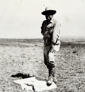
Developing a Datum Using Triangulation
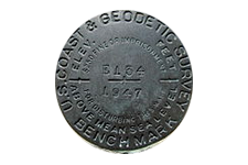
Example of a survey benchmark monument. More recently, surveyors have used markers to set up a GPS receiver antenna in a known position for Differential GPS surveying.
In surveying and mapping large areas, surveyors must take into consideration the curvature of the surface of the Earth and sea-level surface. This is why geodesists developed the geodetic survey network extending across North America. They serve as a basis for North America’s horizontal control data.
With 2 benchmark locations, surveyors use triangulation and trigonometry to measure the direction, distance, and elevation between them. Geodetic leveling can help understand the area and volume of the Earth.
Horizontal control data provide a rigid framework for map makers, engineers, and land surveyors in North America. It makes it possible for greater precision for surveys and to locate national, state, county, and private boundaries with greater precision. Benchmarks are important to surveyors because they help accurately measure the positions of all land boundaries and modern infrastructure.
Who is Responsible for Survey Benchmark Monuments?
In the United States, NOAA’s National Geodetic Survey (NGS) is responsible for managing approximately 240,000 stations gathered over the last two centuries. The National Geodetic Survey Data Explorer makes this data available to the general public.
NGS developed the North American Datum of 1927 which used the Clarke spheroid of 1866 and a point of origin at Meade’s Ranch. Then, NGS developed the more accurate North American Datum of 1983 (NAD 83). The United States, Canada, Mexico, and Central America use this horizontal control datum based on a geocentric origin and the Geodetic Reference System 1980.
- In Canada, Natural Resources Canada’s Geodetic Reference System is responsible for the maintenance of survey benchmarks.
- United Kingdom’s maintenance of benchmarks is provided by the Ordnance Survey.
- In France, it’s the Institut Géographique National that provides this service.
What Types of Benchmarks Exist?
Two main types of benchmarks exist – “vertical control points” and “horizontal control points”.
- Vertical control points contain a precisely measured orthometric height that is measured as height above sea level.
- Horizontal control points simply contain latitude and longitude values.
Within these two broad types of survey benchmarks, there are different types of categories for horizontal control markers as described in NOAA’s Horizontal Control documentation.
INTERSECTION STATIONS are horizontal control marks with landmarks that can be seen from a distance. Examples of intersection stations are water or radio towers. These points can be observed with a telescope using trigonometry to determine their position on Earth.
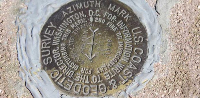
TRIANGULATION STATIONS are markers with positions determined by measuring distances and angles from other stations. Reference marks help keep triangulation stations from being lost with arrows on their disks pointing in the direction of their referenced triangulation station. Azimuth marks, coupled with its triangulation station, provide a compass direction of the true north (which is different from the magnetic north).
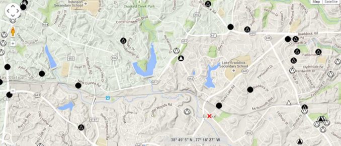
NOAA Geodetic Control Points Data Explorer
Did you know that surveyors have gathered over 240,000 stations over the last two centuries in the United States? The National Geodetic Survey Data Explorer makes this data available to the general public.
From coast to coast dating back to 1832, surveyors have installed benchmarks using a range of different techniques. Surveyors installed survey benchmarks systematically across the region. They have recorded new distances and angles between points.
The NGS database stores each benchmark location with its own unique personal identifier (PID), six-character alphanumeric code, latitude, and longitude. Many have scaled positions from maps.
Types of NOAA Control Points
The National Geodetic Survey Data Explorer shows geodetic control stations maintained by the National Oceanic and Atmospheric Administration (NOAA), National Geodetic Survey.
Here are the various types of NOAA control points:
CONTINUOUSLY OPERATING REFERENCE STATIONS (CORS) NETWORK are control stations with permanently operating Global Positioning System (GPS) receivers.
COMBINED CONTROL STATIONS are horizontal and vertical control stations.
LOW QUALITY STATIONS have low-quality latitudes, longitudes (horizontal), and/or low-quality Orthometric Heights (vertical).
HORIZONTAL CONTROL STATIONS only contain precise latitudes and longitude.
VERTICAL CONTROL STATIONS have precise Orthometric Heights which measure elevation in meters indicating the height above the Geoid.
Note: A single station can be classified in multiple ways – for example having low-quality Orthometric Height and being part of the CORS network.
Geocaching for Survey Monuments (Benchmarking)
The term “benchmark hunting” refers to the hobby of geocaching for historical survey benchmarks. Survey benchmark hunting has carved out its own niche in this exciting hobby.
Why do geocachers seek survey benchmark points?
When you search for a survey benchmark, you really get to see a piece of history. Surveyors haven’t visited these points for decades, even centuries.
When you find these hidden gems placed into the ground years ago, the geocaching community documents and shares them with each other. And you have bragging rights in the community.
There’s a lot of buzz around benchmarks in the geocaching community because there’s almost a hidden history behind them. When you find a survey benchmark, you may be looking at a benchmark surveyed more than a century ago.
Seek out the nearest survey monument to you. Geocache and discover the history of classical surveying.
References
Geodetic Survey Benchmark – Image Courtesy of National Oceanic and Atmospheric Administration and the Department of Commerce


Does anyone know if the Pentagon had any survey benchmarks? I once saw (in the 1990’s) a brass or bronze marker about 4” wide & it said “Pentagon Reservation Boundary” or something like that. I was also itself a 5 sided pentagon shape.
It was one single piece and on the bottom was a ROD (same material) extending perpendicularly downward (as an obvious marker formerly in the ground but sheered off).
I’ve often wondered if anyone knows where the “others” are and if there were 4 or 5 in total. I’ve never seen it written about anywhere.
Hi, I actually found one of these markers at a thrift store in northern Virginia not too long ago! Was doing research and came across your comment. Can’t find anything in these markers. I assumed they were mass produced as souvenirs but maybe not? Mine looks busted up as if it were an actual working marker.
Greetings,
Many, many years ago, a good friend of mine (now deceased) invited me to accompany him to a rather remote (over-grown) area on his property (very near a ‘County Line’ in S.C.) for the expressed purpose to view three [-3-] seldom seen brass/bronze “bench marks” that formed a triad of approx. ninety [-90-] feet. Each bronze marker was mounted atop a rather large (concrete base = the top surface of the base would have probably been less inches (+_), and extended well over 12″ above the ground! I was/am somewhat familiar with some of the local round ‘Bronze Bench Marks’ that in most cases are only a few inches above the ground surface.
QUESTION(s): How rare is such a “triad” as described above? What was
the MAIN reason for such a “triad”? Does an accurate record exist that shows the location(s) of such ‘triads’, and give some general information
concerning the original intended purpose/function of the ‘triad’?
MANY THANKS FOR ANY/ALL TYPE OF RESPONSE!
Regards,
B. LaCoste S. {S.C.}
I think i have a marker in my yard. It’s a round cement but the marker has been removed. Is there a way to know if it is a marker? Is there a web sit that I can put my address in and find out?
It could definitely be one. It depends where you are from. Have you tried the NGS Data Explorer? It’s worth a shot – https://noaa.maps.arcgis.com/apps/webappviewer/index.html?id=190385f9aadb4cf1b0dd8759893032db
I have a geodetic cement marker in my yard her in Brookhaven Mississippi. Dated 1946 with the name Boone within the circle also what does that mean and is it worth anything
Many of the early monuments had published data sheets giving horizontal coordinates based on NAD 27. These same monuments now have coordinates based only on NAD 83. I understand that NGS no longer supports or publishes NAD 27 coordinate data, but I need this NAD 27 coordinate data for a research project I am doing in California, Zone 1 . I need access to the original NAD 27 documents that contained published coordinates, and not those converted from NAD 83 that give approximations . Can you please tell me if there is a site where I can still find this NAD 27 coordinate data? Many thanks.
Is there any history noted with named benchmarks?
How can I log benchmarks that are not listed? I find them all the time, but when I look on the app, Benchmap or on geocaching.com’s website, it doesn’t show up.
Your web site says: “Survey benchmark monuments are brass or metal disks in the ground. They measure exact horizontal positions (latitude and longitude) on the Earth because this gives surveyors a point of reference” Additionally, it says: “A benchmark is a point whose position is known to a high degree of accuracy and is normally marked in some way.”
Benchmarks provide precise orthometric heights. They do NOT necessarily provide precise horizontal positions. Rather, many have scaled positions from maps. Pull any county in the US and you will see both horizontal marks with no orthometric height and BMs with no “adjusted” a.k.a precise positions. It seems the term benchmark is being used interchangeably with geodetic markers or station marker (we even do it at NGS, (sigh)). You may find our FAQs helpful. http://www.ngs.noaa.gov
https://www.ngs.noaa.gov/datasheets/SurveyMarks_FAQ.shtml
Benchmarks do not measure anything. They are just a structure (whether manmade or not onto which an elevation has been attached. To a land surveyor, the word “benchmark” usually means a monument established which is part of a set of survey observations made for the purpose of transferring accurate information to the structures (points) either constructed or used while survey observations were being made.
Humans cannot determine “exact” locations or positions. We are imperfect by nature, therefore our instrumentation is also imperfect. There are so many ways that error occurs during even one observation that we, as humans, cannot eliminate all of them. By making multiple observations, using very accurate equipment in proper working order, we can attain accuracies that are very precise, even to the thousandth of a foot. Surveyors never say that their measurements are “exact”.