What is a Horizontal Datum Reference Frame?

What is a Horizontal Datum?
A horizontal datum provides a reference frame for coordinates on Earth.
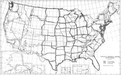
A long time ago, surveyors inserted brass monuments into the Earth with precise X and Y locations. When these monuments were combined using a technique called triangulation, this formed our horizontal datum.
Because all locations reference a datum, we can measure the accuracy of all coordinates in North America.
But different types of horizontal datums exist. We lay out some of these datums below.
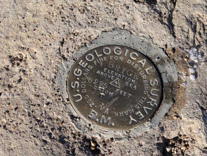
Pinpointing Positions with Survey Benchmarks
A horizontal (geometric) datum (or reference frame) forms a basis for computations of horizontal positions on the Earth.
It is a collection of specific points on the Earth’s surface that have been accurately identified according to their precise northerly or southerly location (latitude) and easterly or westerly location (longitude).
To create the network of horizontal positions, surveyors marked each of the positions they had identified with a brass, bronze, or aluminum disk known as a survey benchmark.
Because surveyors wanted to see one marked position from another, they placed benchmarks on mountaintops or at high elevations. If they were on flat land, surveyors would have towers built to help locate them.
To create a horizontal datum, surveyors connected these monument locations using mathematical techniques like triangulation. The result of triangulation from the unified network of survey monuments was the North American Datum of 1927 (NAD 27) and later the more accurate NAD 83, which is still used today.
NAD 27 and NAD 83 provide a frame of reference for latitude and longitude locations on Earth.
Geographic Coordinate Systems
Real-world objects are defined by coordinate systems. But various coordinate reference systems exist today. In each coordinate system, we can mathematically define geographic locations using a set of coordinate values.
A geographic coordinate system defines three-dimensional coordinates based on the Earth’s surface. It contains an angular unit of measure, prime meridian, and datum (which contains the spheroid).
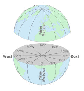
LONGITUDE:
X-coordinates are between -180 and +180, which are called longitudes.
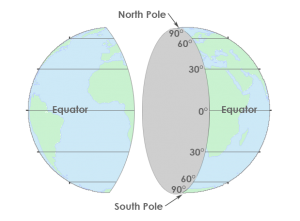
LATITUDE:
Y-values are between -90 and +90 degrees, which are lines of latitudes.
A datum describes the shape of the Earth. In mathematical terms, it defines the radius, major and minor axis, and flattening for an ellipsoid. Then, we reference all coordinates to a datum – including the one you are standing on right now. We incorporate datums in:
- Map projections
- Monitoring the Earth’s crust
- Survey boundary delineation and more
How Do Horizontal Datums Relate to Ellipsoids?
EQUATOR: Horizontal datums give us the capability to measure distances and directions across the surface of the earth. Most horizontal datums define a zero line at the equator from which we measure north and south (latitudes).
GREENWICH MERIDIAN: There is also a zero line at the Greenwich Meridian from which we measure east and west (longitudes).
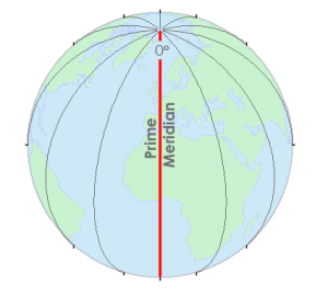
Together, these lines provide a reference for latitude and longitude expressed in decimal degrees. These latitudes and longitude positions (Geographic Coordinate Systems) are based on a spheroid or ellipsoid surface that approximates the surface of the earth – a datum.
We reference all coordinates to a datum. A datum describes the shape of the Earth in mathematical terms. A datum defines the following for an ellipsoid:
- Radius
- Inverse flattening
- Semi-major axis
- Semi-minor axis
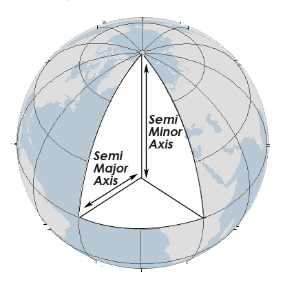
For example, here is the WGS84 datum:
SEMI-MAJOR AXIS: 6,378,137.0m
SEMI-MINOR AXIS: 6,356,752.3m
INVERSE FLATTENING: 294.978698214
Conclusion
Coordinates reference systems, geoids, latitudes, and longitudes, projections, datums, ellipsoids…
Every GIS analyst needs a good base understanding of what they are and how it relates to location.
Because you can’t just put anything on a map without understanding its horizontal reference system.
If you’re still trying to grasp a better concept, here are more articles that can help:
References
Image Credit: National Oceanic and Atmospheric Administration and the Department of Commerce


How does movement to continental/oceanic plates affect, if at all, the data in a horizontal datum?
Tectonic plates move ~ 1–10 cm per year. And over time, this creates measurable coordinate shifts. I haven’t been in touch with how NGS will be replaced… but apparently this new system will take into account plate movements.
Sorry, I couldn’t be more help
What sets of data are usually included in horizontal datum
Great website, very informative. Thank You!