New York County Map

You are free to use our county map of New York for educational and commercial uses. Attribution is required. How to attribute?
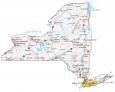
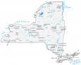
About the map
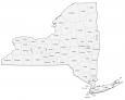
This New York county map displays its 62 counties. New York City is divided into New York County (Manhattan), Kings County (Brooklyn), Bronx County (The Bronx), Queens County (Queens), and Richmond County (Staten Island). So, despite the fact New York City is the most populated city in the United States with 8.4 million people, its populations are distributed rather evenly between these 5 counties.
New York’s most populated county is King’s County with over 2.5 million people. Next, Queens County has a bit over 2.25 million. This is followed by New York County, Suffolk County, and Bronx County. The county with the lowest population in New York is Hamilton County with under 5,000 people.
For size, Saint Lawrence County is the largest with an area of 2821.3 square miles. The smallest county is New York County with just under 23 square miles of area. The counties that belong to Long Island are Kings, Queens, Nassau, and Suffolk from west to east.
New York County List
| FIPS Code | Name | Land (sq mi) | Water (sq mi) | Population (2024) |
|---|---|---|---|---|
| 36-001 | Albany County | 522.8 | 10.5 | 319,964 |
| 36-003 | Allegany County | 1029.4 | 5.0 | 47,299 |
| 36-005 | Bronx County | 42.0 | 15.3 | 1,384,724 |
| 36-007 | Broome County | 705.8 | 9.7 | 196,397 |
| 36-009 | Cattaraugus County | 1308.3 | 14.1 | 75,475 |
| 36-011 | Cayuga County | 691.6 | 172.1 | 74,567 |
| 36-013 | Chautauqua County | 1060.2 | 440.0 | 124,105 |
| 36-015 | Chemung County | 407.3 | 3.4 | 81,115 |
| 36-017 | Chenango County | 893.6 | 5.0 | 45,776 |
| 36-019 | Clinton County | 1037.7 | 79.8 | 77,871 |
| 36-021 | Columbia County | 634.7 | 13.5 | 60,299 |
| 36-023 | Cortland County | 498.8 | 2.7 | 45,945 |
| 36-025 | Delaware County | 1442.4 | 25.0 | 44,191 |
| 36-027 | Dutchess County | 795.6 | 29.7 | 299,963 |
| 36-029 | Erie County | 1042.7 | 184.1 | 950,602 |
| 36-031 | Essex County | 1794.1 | 122.1 | 36,744 |
| 36-033 | Franklin County | 1629.2 | 68.2 | 47,086 |
| 36-035 | Fulton County | 495.5 | 37.4 | 52,073 |
| 36-037 | Genesee County | 492.9 | 2.4 | 57,604 |
| 36-039 | Greene County | 647.2 | 10.9 | 46,903 |
| 36-041 | Hamilton County | 1717.4 | 90.4 | 5,082 |
| 36-043 | Herkimer County | 1411.5 | 46.5 | 59,585 |
| 36-045 | Jefferson County | 1268.7 | 588.7 | 113,140 |
| 36-047 | Kings County | 69.4 | 27.5 | 2,617,631 |
| 36-049 | Lewis County | 1274.6 | 15.3 | 26,570 |
| 36-051 | Livingston County | 631.8 | 8.5 | 61,561 |
| 36-053 | Madison County | 654.9 | 6.4 | 67,072 |
| 36-055 | Monroe County | 656.9 | 709.8 | 752,202 |
| 36-057 | Montgomery County | 403.1 | 7.2 | 49,648 |
| 36-059 | Nassau County | 284.6 | 168.9 | 1,392,438 |
| 36-061 | New York County | 22.7 | 11.0 | 1,660,664 |
| 36-063 | Niagara County | 522.4 | 617.3 | 209,570 |
| 36-065 | Oneida County | 1212.3 | 45.3 | 228,347 |
| 36-067 | Onondaga County | 778.4 | 27.2 | 469,812 |
| 36-069 | Ontario County | 644.0 | 18.5 | 113,012 |
| 36-071 | Orange County | 812.3 | 26.3 | 411,767 |
| 36-073 | Orleans County | 391.3 | 426.2 | 39,686 |
| 36-075 | Oswego County | 951.6 | 360.4 | 118,305 |
| 36-077 | Otsego County | 1001.7 | 14.0 | 60,524 |
| 36-079 | Putnam County | 230.3 | 15.9 | 98,409 |
| 36-081 | Queens County | 108.8 | 69.3 | 2,316,841 |
| 36-083 | Rensselaer County | 652.5 | 12.9 | 160,749 |
| 36-085 | Richmond County | 57.5 | 44.8 | 498,212 |
| 36-087 | Rockland County | 173.4 | 25.8 | 348,144 |
| 36-089 | St. Lawrence County | 2679.3 | 142.0 | 106,198 |
| 36-091 | Saratoga County | 810.0 | 33.8 | 240,360 |
| 36-093 | Schenectady County | 204.6 | 4.9 | 162,261 |
| 36-095 | Schoharie County | 621.8 | 4.5 | 30,151 |
| 36-097 | Schuyler County | 328.3 | 14.0 | 17,121 |
| 36-099 | Seneca County | 323.7 | 66.7 | 32,650 |
| 36-101 | Steuben County | 1390.5 | 13.5 | 92,015 |
| 36-103 | Suffolk County | 911.8 | 1461.4 | 1,535,909 |
| 36-105 | Sullivan County | 968.1 | 28.6 | 80,450 |
| 36-107 | Tioga County | 518.6 | 4.3 | 47,574 |
| 36-109 | Tompkins County | 474.6 | 16.9 | 105,602 |
| 36-111 | Ulster County | 1124.2 | 36.5 | 182,977 |
| 36-113 | Warren County | 867.2 | 64.4 | 65,288 |
| 36-115 | Washington County | 831.2 | 14.7 | 59,839 |
| 36-117 | Wayne County | 603.8 | 779.2 | 90,757 |
| 36-119 | Westchester County | 430.6 | 69.4 | 1,006,447 |
| 36-121 | Wyoming County | 592.7 | 3.5 | 39,588 |
| 36-123 | Yates County | 338.1 | 37.6 | 24,387 |