Latitude, Longitude and Coordinate System Grids

Latitude, Longitude, and Coordinate System Grids
Here’s how you can remember latitude and longitude:
Latitude lines run east-west and are parallel to each other but measure north-north. So if you go north, latitude values increase. Finally, latitude values (Y-values) range between -90 and +90 degrees.
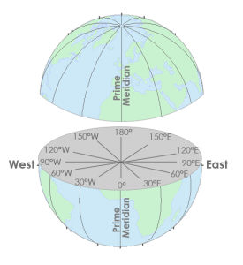
But longitude lines run north-south and measure east-west. They converge at the poles. And its X-coordinates are between -180 and +180 degrees.
Latitude and longitude coordinates make up our geographic coordinate system.
Map Coordinate Systems
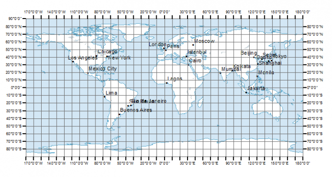
You can give any location on Earth latitude and longitude coordinates.
The field of study that measures the shape and size of the Earth is geodesy. Geodesists use coordinate reference systems such as WGS84, NAD27, and NAD83. In each coordinate system, geodesists use mathematics to give each position on Earth a unique coordinate.
A geographic coordinate system defines two-dimensional coordinates based on the Earth’s surface. It has an angular unit of measure, prime meridian, and datum (which contains the spheroid).
As shown in the image below, lines of longitude have X-coordinates between -180 and +180 degrees.
On the other hand, lines of latitudes have Y-values that are between -90 and +90 degrees.
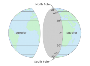
The equator is where we measure north and south. For example, everything north of the equator has positive latitude values. Whereas, everything south of the equator has negative latitude values.
The Greenwich Meridian (or prime meridian) is a zero line of longitude from which we measure east and west. In fact, the zero line passes through the Royal Observatory in Greenwich, England, which is why we call it what it is today.
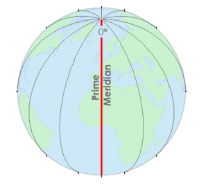
In a geographical coordinate system, the prime meridian is the line that has 0° longitude. Most horizontal datums assign the equator as a zero line of latitude.
The equator is where we measure north and south. Whereas, the Greenwich Meridian (or prime meridian) is a zero line of longitude from which we measure east and west.
Together, these lines provide a reference for latitude and longitude that always zig-zag into each other. This geographic grid gives unique latitude and longitude for every position on Earth.
Find Anything on Earth with Coordinates
Coordinates are pairs (X, Y) in a two-dimensional space referenced to a horizontal datum. Whereas triplets (X, Y, Z) of points not only have a position but also has height referenced to a vertical datum. In other words, the X- and Y-values represent a horizontal position. Whereas, the Z-value represents the vertical position.
Geographic coordinate systems use an ellipsoid to approximate all locations on the surface of the earth. Whereas, the datum defines the surface.
A horizontal datum has a major axis, which is the longest diameter of an ellipse. Also, it has a minor axis, which is the shortest diameter of an ellipse. Finally, a horizontal datum has a radius that represents the position of the surface relative to the center of the earth.
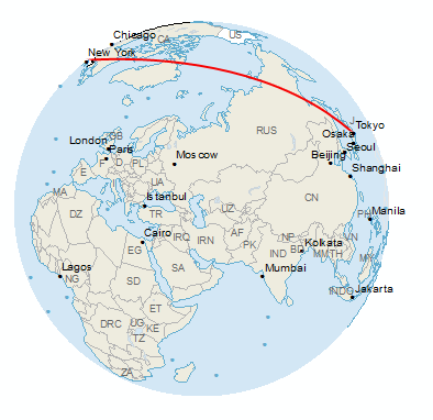
Additionally, time zones roughly use lines of longitude at 15° intervals. Starting at the Prime Meridian, there are 24 different time zones in the world, as shown in the world time zone map.
What is a Coordinate Reference System?
A reference ellipsoid is the mathematical model of the shape of the Earth with the major axis along the equatorial radius.
A geographic coordinate system uses longitude and latitude expressed in decimal degrees. For example, WGS 1984 and NAD 1983 are the most common datums in use today. Before 1983, NAD27 was the most common datum.
Cartographers write spherical coordinates (latitudes and longitudes) in degrees-minutes-seconds (DMS) and decimal degrees. For degrees-minutes-seconds, minutes range from 0 to 60. For example, the geographic coordinate expressed in degrees-minutes-seconds for New York City is:
- Latitude: 40 degrees, 42 minutes, 51 seconds N
- Longitude: 74 degrees, 0 minutes, 21 seconds W
You can also express geographic coordinates in decimal degrees. It’s just another way to represent that same location in a different format. For example, here is New York City in decimal degrees:
- Latitude: 40.714
- Longitude: -74.006
The Federal Communications Commission has a DMS-Decimal converter tool that converts latitude and longitude between decimal degrees and degrees, minutes, and seconds.
Latitude, Longitude, and Spherical Coordinate System Grids
When you put two coordinates together as a pair (X, Y), you can locate anything on Earth.
Latitude and longitude form our coordinate system grid.
Also, you can express coordinates in different ways. For example, you can use decimal degrees or degrees-minutes-seconds.
Thanks to our geographic coordinate system, you can pinpoint any point on Earth such as GPS receivers. This includes the spot where you are reading this article right now.


Can someone explain the min and sec
At the beginning you states:
“Latitude lines run east-west”
“But longitude lines run north-south.”I have a similar question from Maryland. I have a plot plan that contains reference N: 429,433.02 and E: 1,455,456.46. This is an IPF location. Any suggestions?
These are UTM coordinates as northings and eastings, aren’t they?
your coordinate is UTM projection (NE) so Value of 429433.02 N is metre distance from Equator to North and 1455456.46E is from left side of Zone boundary(no Zone number ).Because the value of 1455456.46E can be any zone for same latitude. You should see about UTM projection
Please explain this to a 6 year old
You say:”Together, these lines provide a reference for latitude and longitude that always zig-zag into each other. This geographic grid gives unique latitude and longitude for every position on Earth.”
the zig-zag is not the only way ton explain the locations, many locations go straight away up or down…
Hi,
At the beginning you states:
“Latitude lines run east-west”
“But longitude lines run north-south.”
It’s the opposite! Thank you for correcting!
It’s true actually – lines of latitude do run east-west. But they measure north-south.
I’ve updated the article to clarify that concept. Thanks!
We write the latitudes and longitudes of a place like 20 degrees N and 10 degrees E. This means we mention the latitudes first and then the longitudes. How are grid references different from this? We write the value of Eastings first and then the Northings where Eastings represent the standing lines and Northing represent the sleeping lines. Please explain the difference.
“Latitude, Longitude, and Spherical Coordinate System Grids
When you put two coordinates together as a pair (X, Y), you can locate anything on Earth.”
“For example, here is New York City in decimal degrees:
Latitude: 40.714
Longitude: -74.006”
Surely this is backward? Why would you have the x-axis going north/south and the y-axis going east/west??
No, this is correct. Latitude is the distance north/south away from the equator.
Right you say! that’s mean value of Latitude is along the Longitude or Meridian line and value of Longitude is along the Latitude or Parallel because of Lat and Long are perpendicular each other ok!
For those referring to (land?) Plot plans, these use a different datum(?) than geographic coordinates. They are based on bearings, not locations in (x,y,z), and depend on a fixed starting point other than (0,0,0).
I’m super confused on the minutes and seconds part. Can someone explain it to me?
In our model of the earth, we have 180 degrees of latitude (measuring north-south, typically written with the equator as “zero”) and 360 degrees of longitude (measuring east-west, with the “zero” line running north/south through Greenwich, England). In practice, given the circumference of the earth, that means each degree is about 60 nautical miles (which are about 15% larger than the statute miles used for the odometer of your car) at the equator. Each degree is divided into 60 minutes (so each minute is about 1 nautical mile at the equator) and each minute is divided into 60 seconds. This division allows us to state locations pretty exactly (a second is only about 100 feet at the equator).
Note that I keep writing, “at the equator”. Because we are modeling a three-dimensional, nearly spherical earth in two dimensions, the longitude lines actually converge as we approach the poles (think about drawing our geographic grid on one of those Spaldeen balls kids use for kickball). The north-south distances remain 1 nautical mile for each minute, but the east-west distances get much smaller as we go north (and south) away from the equator. Using the degrees/minutes/seconds notation allows us to ignore the fact that the distances between the longitude lines get much smaller (we can calculate the distances if we need to, but we can keep the directions consistent so that south is always south, even when the longitude lines get really close together near the poles)
So how is coordinate geometry found in latitude and longitude??????
What are the special grids on a map?
To remember latitude is like climbing up and down a stairway. You go up in latitude and down in latitude. Thus, you go from the equator, 0 deg up to 90degs up to the North Pole, and equator, 0 deg down to -90 degs to the South Pole. As for longtitude, is the horizontal movement at 0 deg from 0 deg at Prime Meridian to the East or from 0 deg at Prime Meridian to the West.
I learnt latitude – in the door’, longitude – up the stairs. Doors have mats, that rhyme with lat and it’s a long way up the stairs.
It works when map reading too.
What is the way to get the distance from one reading to a second reading ex 51.50 -47.25
How do we know if they are negative
Negative longitude means it’s west of the prime meridian. But negative latitudes means that it’s south of the equator. I would plug the latitude and longitude values in, and see where they land. If the coordinates make sense, then you would know if it’s negative or positive.
How can the size of an area delineated by latitude and longitude be calculated?
You would need at the very least 3 coordinates. Then, convert point to polygon and calculate area. All can be done in QGIS.
Ha, Hallo! Awful question and I am sure you’re no the correct forum, but maybe you can guide me in this difficult process. Live in Stockholm, Sweden, hired a carpenter that later charged me 2.5 the agreed amount, he didn’t finish the job after 7 weeks and I fired him. He was supposed to be due in 2 weeks! Now I am being sued in court and I try to get data from his mobile telephone, GPS locations, as he has not been in my Stockholm apartment as he states. Stockholm police can assist me if a DA agrees, and if not, the court will not assist. You have any guidance?
if this is a real problem then just get another carpenter
Hi – very nice document on goegraphy, coordinates and projections – all though I think something is wrong in the section “Find Anything on Earth with Coordinates”. It says “In other words, the X-value represents the horizontal position. Whereas, the Y-value represents the vertical position.”
I think the correct words would be:
In other words, the X- and Y-values represents the horizontal position. Whereas, the Z-value represents the vertical position.
Thanks for the suggestion. I updated the post.
Dennis Crane, if you still look here and haven’t had an answer about your Maryland coordinates, there was a program on the internet called “Corpscon7” which can convert coordinates like you have to regular LON LAT coordinates. It takes a little playing with, and a little knowledge, but it works great.
In football, running North-South is to move down the length of the field ?!?
Think in basic football terms.
A Lateral pass is a cross field pass Latitude North – South
Go Long is a downfield pass Longitude East – West
This is an interesting analogy! Thanks for the comment
Interesting article. In some cases it’s required to incorporate a distance correction factors depending on your location and main reference point for the specific project,therefore, this correction factor can be bigger or smaller than 1 that can result in greater or smaller distances on the earth compare with the UTM grid.
In my current project we use what they’ve called Plant Coordinates which are UTM affected by the correction factor.
Is there a reason that latitude and longitude are given in that order instead of longitude and latitude? As I understand the map, it’s like using a coordinate pair of (y,x) instead of (x,y) which is what’s taught in school. Am I reading that incorrectly, or is there a reason for that convention?
Think “ladder” for latitude (north south)
Long for longitude since longitude has a “longer” range of values up to 180 degrees, compare to up to 90 degrees for latitude
Thanks for the comments on GISGeography, David! Very helpful for anyone learning these concepts.
I have a similar question from Maryland. I have a plot plan that contains reference N: 429,433.02 and E: 1,455,456.46. This is an IPF location. Any suggestions?
I have a set of property drawings of the public bus depot in Rochester, NY done in 1974. It shows the coordinates of the corners of the buildings on the property. The format of the coordinates is strange; for example, instead of the usual North and West, the first number is identified as “South,” the second as “East.”
For example: 49,957.44 South, 42,117.36 East. I thought they might be State Plane Coordinates, but I’ve confirmed that they are not. Ultimately I need to convert them into “normal” lat/long coordinates, but my question for now is just, what format is this?
The longitudinal lines are perpendicular to the equator. Are the longitudes perpendicular to the latitudes?