Satellite Map of USA – United States of America
Download our satellite map of the United States. It’s free to use for any purpose. Or choose from any of the 50 states for more satellite maps of the USA.
Download our satellite map of the United States. It’s free to use for any purpose. Or choose from any of the 50 states for more satellite maps of the USA.
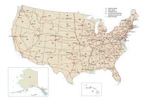
A US road map that displays major interstate highways, limited-access highways and principal roads in the United States including states and capital cities.
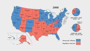
In this US election map collection, you will find the history of presidential elections from 1789 to 2020. Who won the electoral vote in each election year?
This map of the United States of America displays cities, highways, rivers and lakes. It includes the 50 states of America and capital of Washington, DC.
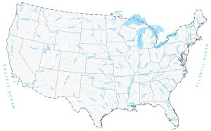
Download our lakes and rivers map of the United States. It’s free to use for any purpose. Or select from any of the 50 states for detailed lakes and rivers.
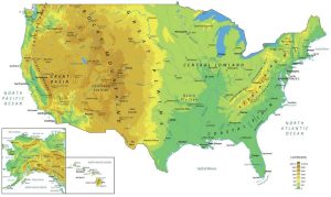
A physical map of the United States that features mountains, plateaus, lakes, rivers, cities and capitals. It includes inset maps for Hawaii and Alaska.
These are the 30 defining maps of the United States. This United States map collection has everything from reference, climate and elections.
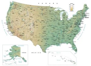
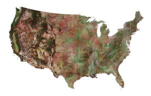
This map of USA displays states, cities and census boundaries. An elevation surface highlights major physical landmarks like mountains, lakes and rivers.
A US county map that displays the 3,142 counties and equivalents including parishes, boroughs, census areas, independent cities and the District of Columbia.
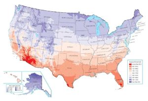
Check out the US temperature map to visualize how climate varies across the United States of America. Each one is derived from NESDIS, a branch of NOAA.