MMQGIS Plugin: Get More Out of QGIS
The MMQGIS Plugin
MMQGIS is a QGIS plugin that contains a collection of GIS tools to simplify data manipulation.
The plugin name, MMQGIS, comes from the name of its developer and maintainer, Michael Minn.
In terms of downloads, it’s one of the top ten downloaded plugins and consistently gets high usage.
MMQGIS provides some capabilities that are not readily available in the Processing toolbox. Let’s take a look at what they are.
MMQGIS Tools
The MMQGIS Plugin contains seven toolsets that add core functionality. Each one comes with a set of tools to help you get the most usage out of QGIS. Here are the toolsets that are a part of MMQGIS:
1. Animate
Animate – Although the animation tools are a bit rudimentary, MMQGIS allows you to create frames so you can build simple animations in QGIS. The tool plots successive rows in a layer – or more than a single layer. This is an exemplary visualization common for showing vectors in a flow map such as the direction of goods traveled.
2. Combine
The “combine” toolset gives you a day of tools for integrating more than one dataset. Here are some of the algorithms that are a part of this toolset.
- Join attributes from CSV layer
- Merge layers to create a new output
- Spatial join that joins attributes based on location (Intersect, within, contains)
3. Create
As the name implies, this set of tools allows you to build derived datasets based on an input or a collection of inputs. Here are some of the capabilities of these tools.
- Create buffers with a set radius and number of edges
- Create a grid layer
- Hub lines – Connect the source and destination points
- Voronoi diagram with points as inputs
4. Geocode
The geocoding tools in MMQGIS are a major part of the reason why this plugin gets so many downloads. Turn your addresses into geocoded points. Or vice versa, you can convert your current point file into addresses.
- Bulk Geocoding – Input is a CSV with address, city, and state. Creates points based on each record address
- Reverse Geocoding – Use an existing set of points and find addresses.
5. Import/Export
These tools are designed for simple conversion between a few selected formats. Either you can work with CSV or KML giving functionality to import and export
- Export attributes or geometry to CSV
- Import geometry from CSV
- Google Maps KML export
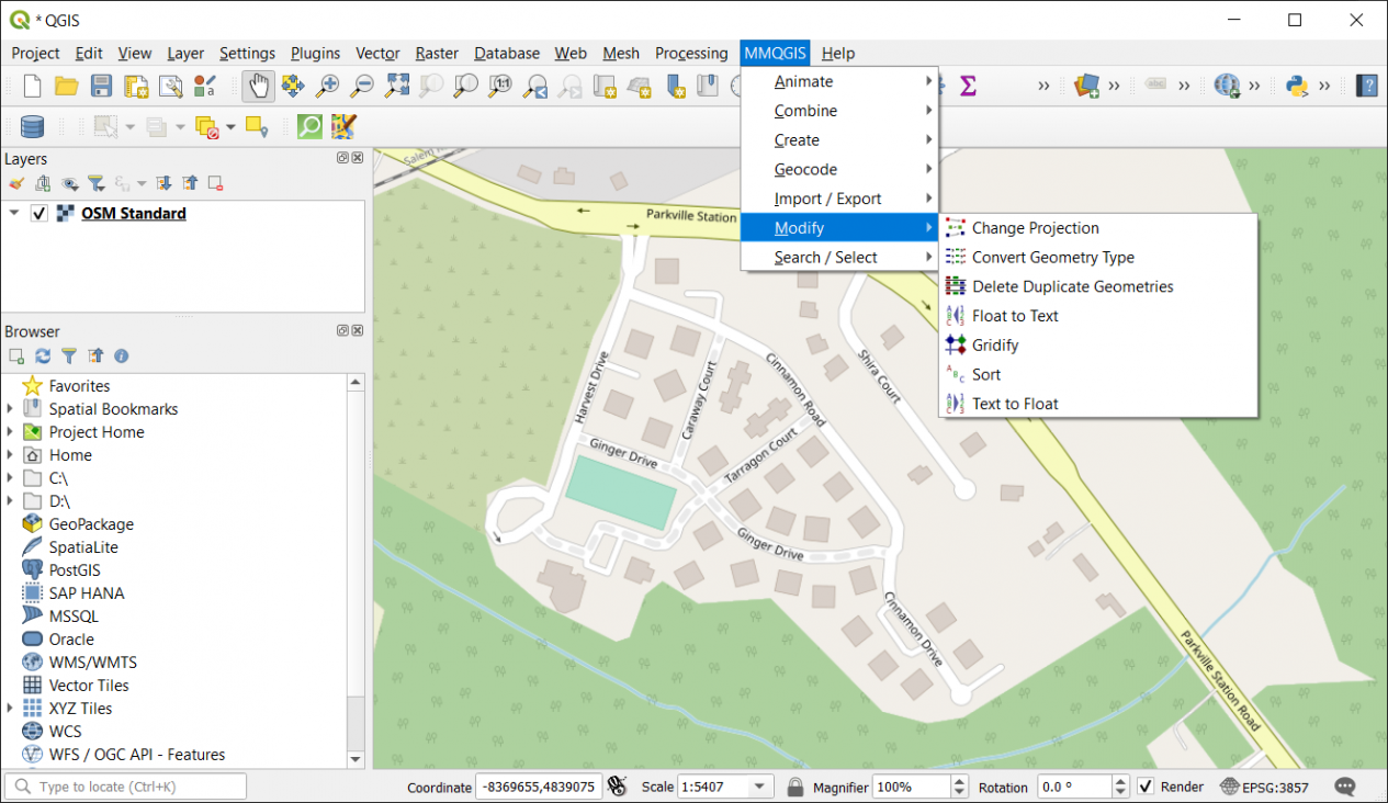
6. Modify
These tools are for modifying your existing data through geometry updates, field changes, or projecting features. You can also locate duplicate geometry or simplify features by aligning vertices to a grid
- Change layer projection
- Convert geometry types (points, lines, and polygons)
- Delete duplicate geometry
- Float to text – Converts a column from float to text
- Gridify – Simplifies points, lines, and polygons by aligning vertices to a grid.
- Sort – Sorts records of a shapefile
- Text to float – Converts a column from text to float
7. Search/Select
This is more of a user interface capability, where you can interactively browse through each record in a data source. Alternatively, you can set the search criteria and match the value based on that query.
Summary: MMQGIS
To exploit the full potential of QGIS, MMQGIS offers a unique set of tools to handle geospatial data in QGIS.
This plugin for QGIS enables you to get access to advanced capabilities not readily available in the Processing toolbox.
For instance, you can add geocoding capabilities, animation tools, and a stealthy interface for searching through your GIS data.
If you need any of these capabilities, make sure to give the free MMQGIS plugin a try today.


