QGIS Plugins: The Lifeblood of Open Source GIS
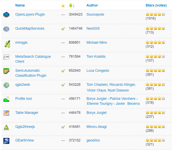
QGIS Plugins Repository
If you’ve ever used QGIS before, you’ll know that QGIS plugins are a centerpiece to its success.
Because when you install a QGIS plugin, you can bolster everything from visualization to analysis, and editing.
It’s this open approach that has done exceedingly well and makes QGIS 3 the most active open source GIS software today.
What are some of the top plugins today? You can easily sort by what’s most downloaded in the QGIS Plugin Repository. Otherwise, read more to know which QGIS plugins we like the most.
The QGIS plugin repository
Tap into 1500+ plugins to lay a solid foundation. tools. Here are some of our favorite QGIS plugins below.
- QuickMapServices – Finds available base maps and web services for any location you zoom in and out. At the very least, you can get OpenStreetMap, Esri, or Google satellite imagery for wherever you are in the world.
- Semi-Automatic Classification – An image classification plugin for supervised classification of coarse resolution imagery. Also, it provides utilities to download and process satellite data.
- go2streetview – If you want to check out the view of an area, Go2StreetView brings up a Google Street View of any location you click on a map.
- QuickOSM – As the name suggests, you can use this plugin to view and download OSM data. You can also query the area or extent as well as the layers and columns from OSM data.
- QGIS2Web – This plugin packages your current QGIS project as a web-compatible map. For example, you can create an OpenLayers, Leaflet, or Mapbox GL JS web map.
- OpenLayers – When someone installs a fresh version of QGIS, people turn to OpenLayers for base maps like Google Maps, Bing Maps, and OpenStreetMap (QGIS 2).
- MMQGIS – A set of plugins for vector analysis. One of the most notable is its geocoding capabilities. When you add a spreadsheet (CSV) of addresses, it can process them in bulk and add them all to your map canvas. Here’s our article on the MMQGIS plugin.
Sponsor or Donate to QGIS
Remember that even without plugins, QGIS 3 has 900+ geoprocessing tools in total that can be divided into the following toolboxes.
- QGIS 3 Toolbox (201 Tools)
- GDAL Toolbox (50 Tools)
- GRASS GIS Toolbox (298 Tools)
- SAGA GIS Toolbox (361 Tools)
As the leading open source GIS software available today, QGIS is developed by a team of dedicated volunteers, companies, and organizations.
Donations or sponsorship to QGIS is always welcome to continue the success of this open source GIS project.


@Richard ;- Rude. Is it necessary to thow an insult?
It seems like you don’t know that Quick Map Services kinda replaced OpenLayers. You have to install the community plugin (Google Maps, Waze, OSM, ESRI,….ALL Maps contained) because it seems like you got no idea of how to use it right because really at least…it replaced the OpenLayers plugin years ago for Pros. Its basically a really good XYZ Service.