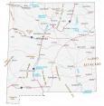
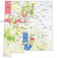
New Mexico County Map

About the map
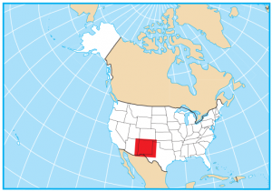
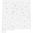
This New Mexico county map displays its 33 counties. New Mexico shares a border with Arizona, Colorado, Utah, Texas, and Oklahoma. Not to mention, it also shares an international border with Mexico.
For area, Catron County is the largest county in New Mexico occupying an area of almost 7000 square miles. Bernalillo is the most populated county in New Mexico and is home to the city of Albuquerque. New Mexico also has one of the least populated counties in the entire United States, Harding County.
The smallest county is Los Alamos. This is the location of the Los Alamos Scientific Laboratory and Manhattan Project. As seen in the film “Oppenheimer”, it’s here that laid the groundwork for the fabrication of the atomic bomb.
You are free to use our county map of New Mexico for educational and commercial uses. Attribution is required. How to attribute?
New Mexico County List
| FIPS Code | Name | Land (sq mi) | Water (sq mi) | Population (2024) |
|---|---|---|---|---|
| 35-001 | Bernalillo County | 1161.3 | 6.1 | 671,747 |
| 35-003 | Catron County | 6924.2 | 5.5 | 3,795 |
| 35-005 | Chaves County | 6067.1 | 7.9 | 63,697 |
| 35-006 | Cibola County | 4540.0 | 2.1 | 26,686 |
| 35-007 | Colfax County | 3758.0 | 10.2 | 12,307 |
| 35-009 | Curry County | 1405.4 | 3.2 | 47,156 |
| 35-011 | De Baca County | 2323.1 | 11.2 | 1,657 |
| 35-013 | Doña Ana County | 3808.2 | 6.8 | 229,366 |
| 35-015 | Eddy County | 4176.4 | 21.7 | 61,436 |
| 35-017 | Grant County | 3961.2 | 5.9 | 27,541 |
| 35-019 | Guadalupe County | 3029.8 | 1.1 | 4,385 |
| 35-021 | Harding County | 2125.5 | 0.4 | 635 |
| 35-023 | Hidalgo County | 3438.5 | 9.1 | 3,966 |
| 35-025 | Lea County | 4391.4 | 3.2 | 75,151 |
| 35-027 | Lincoln County | 4831.1 | 0.2 | 20,025 |
| 35-028 | Los Alamos County | 109.2 | 0.1 | 19,675 |
| 35-029 | Luna County | 2965.2 | 0.2 | 25,878 |
| 35-031 | McKinley County | 5450.7 | 5.3 | 68,945 |
| 35-033 | Mora County | 1926.2 | 2.4 | 4,096 |
| 35-035 | Otero County | 6612.5 | 14.3 | 69,711 |
| 35-037 | Quay County | 2873.9 | 7.2 | 8,403 |
| 35-039 | Rio Arriba County | 5860.8 | 35.3 | 39,955 |
| 35-041 | Roosevelt County | 2446.0 | 7.2 | 18,713 |
| 35-043 | Sandoval County | 3710.1 | 4.2 | 157,757 |
| 35-045 | San Juan County | 5517.2 | 21.2 | 120,817 |
| 35-047 | San Miguel County | 4721.5 | 19.8 | 26,428 |
| 35-049 | Santa Fe County | 1910.1 | 1.3 | 157,765 |
| 35-051 | Sierra County | 4181.2 | 57.0 | 11,389 |
| 35-053 | Socorro County | 6646.4 | 1.9 | 15,967 |
| 35-055 | Taos County | 2202.4 | 1.3 | 34,482 |
| 35-057 | Torrance County | 3345.2 | 0.9 | 15,986 |
| 35-059 | Union County | 3825.0 | 6.0 | 3,926 |
| 35-061 | Valencia County | 1066.7 | 1.1 | 80,813 |