Satellite Image of Earth – Blue Marble (NASA)

The 5 Blue Marbles
Blue Marble is a term used to describe the image of our planet floating in the vastness of space.
It was the crew of the Apollo 17 mission that first captured the iconic satellite image of Earth back in 1972 and called it the “Blue Marble”.
But since then, NASA has undergone several updates to this satellite image of Earth, which are available in the public domain and are for reuse.
Here are the 5 versions of the Blue Marble (Apollo 17 was the first). We will also list the sources on how you can download NASA Earth images and obtain this complete Earth satellite view.
2002 Blue Marble
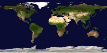
The 2002 version of the Blue Marble is a 1 km per pixel detailed satellite image of Earth in natural color.
This version is based on imagery from the Terra satellite’s Moderate Resolution Imaging Spectrometer (MODIS). The imagery was collected over a period of 4 months.
The full resolution cloudless satellite image of Earth consists of 21,600 pixels across and is over half a gigabyte in size.
These images are freely available to the public through the NASA Visible Earth website. They are available in either georeferenced or unstructured formats.
2005 Blue Marble

NASA’s next release of the Blue Marble was in 2005, which included a much-improved 500-meter per pixel spatial resolution.
Just like other Blue Marble products, you can download this cloud-free globe from NASA’s Earth Observatory website.
NASA didn’t only improve the sharpness and quality of this satellite map of the world.
But it also augmented its capabilities to remove clouds and improve the visual appearance of seasonal changes.
READ MORE: NASA Earth Observatory: Global Environment and Climate Data
2012 Blue Marble

The 2012 version of the Blue Marble is a 64-megapixel (8000 x 8000) composite image of the western and eastern hemispheres.
This satellite image of Earth consists of data collected from the VIIRS (Visible/Infrared Imager Radiometer Suite) instrument onboard the Suomi NPP satellite.
The collection of the 2012 Blue Marble subsequently prompted the creation of Black Marble (Earth at Night), which is a nighttime view of the Earth.
The 2012 Black Marble is available through the EOSDIS Worldview Earthdata website. Whereas the Blue Marble is available through Flickr. Yes, Flickr.
Return of the Blue Marble (2015)
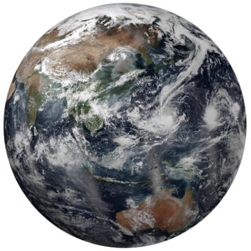
The 2015 version of the Blue Marble takes a different perspective from the previous versions. This is because it includes clouds and is just a single photograph taken on July 6, 2015.
Onboard the U.S. Deep Space Climate Observatory (DSCOVR) in a unique location called the Lagrange point, it collected a day’s worth of imagery when North America was relatively cloud-free.
DSCOVR collected this satellite image of Earth a million miles away between the Sun and our planet (but farther than that moon) to get a full view of the blue marble we call Earth.
The 2015 version of the Blue Marble is available on NASA’s Hyperwall and is also available in video format or as a flat map texture.


The most eminent feature of the “Blue Marble” photo, the image uniformity, is not discussed in the literature, not even mentioned. The earth’s image includes large areas of gas-phase – clouds, liquid-phase – oceans, and solid-phase – land, and the uniformity is nearly true for each phase separately. This feature is not compatible with Lambert’s cosine law. One photo – a thousand theories.