How To Think Spatially with Spatial Relationships
How We Use Spatial Relationships in GIS
Here are a couple of quotes that all good geographers should remember to better understand the concept of spatial relationships.
“Everything is related to everything else. But near things are more related than distant things.”
Waldo R. Tobler
“GIS is the nervous system for the planet.”
Jack Dangermond
“Geography has made us neighbors. History has made us friends. Economics has made us partners, and necessity has made us allies.”
John F Kennedy
What each quote implies is that geography is connected. And this is the same as spatial relationships because they identify how features relate to one another in geographic space.
What Does It Mean to Be “Spatially Intelligent”?
Being “spatially intelligent” refers to a person’s ability to understand, perceive, and work with spatial information effectively. This type of intelligence is one of the multiple intelligences identified by psychologist Howard Gardner in his “Theory of Multiple Intelligences”.
For example, spatially intelligent individuals have a keen spatial perception of their physical environment. They can quickly and accurately perceive the spatial relationships between objects, shapes, and structures.
Spatially intelligent individuals are usually adept at reading maps, understanding directions, and navigating in both familiar and unfamiliar environments. They have a good sense of direction and can create mental maps of spaces.
Finally, spatially intelligent people are often skilled at mental rotation, problem-solving, spatial memory, mechanical skills, and spatial reasoning.
READ MORE: Geospatial vs GIS: What’s the Difference?
Spatial Relationships Types
Adjacency, contiguity, overlap, and proximity are the four ways of describing the relationship between two or more entities.
ADJACENCY: Adjacency is when two polygon entities are directly connected to each other sharing a boundary.
CONTIGUITY: Contiguity is the relationship between two or more entities when they share an edge such as the 48 contiguous states.
OVERLAP: An overlap occurs when a single entity shares the same location or partial location of another entity.
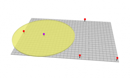
PROXIMITY: Finally, proximity is defined as being close enough that you can establish contact with each other without having physical contact with each other.
There is no single rule for what a spatial relationship between two objects is. But the common types of spatial relationships include overlap, proximity, contiguity, and adjacency.
Spatial Joins and Geographic Relationships
A spatial join is a powerful tool in the GIS world. It allows you to connect or join data together, by sharing layers with the same attributes based on location. In GIS, you can achieve the spatial join through different spatial relationships.
| Spatial Join Type | Description |
|---|---|
| Intersect | Two features touch at any location. An Intersect is commonly used to describe a point where two or more lines, planes, or surfaces meet. |
| Within a distance | Two features are within a set distance. This spatial relationship is defined by how far two or more entities can be found on a map. |
| Completely within | The join feature is within the target feature. This type of geographic relationship involves a feature completely being inside the other. |
| Identical | Both features match identically. When two features are exactly without having any difference or variant of any kind, the features are identical. |
| Closest | The join feature is closest to the target feature. When there are several possible features to join, this spatial join takes only the closest feature. |
Topological Relationships in GIS
A topological relationship exists when two objects are each connected to one another. But one object has a specific set of rules that dictate their relationship. When you create topological relationships, it ensures that related features are clean and free of error.
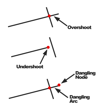
DANGLES: When the end vertex of a line does not snap to a point, line, or polygon resulting in a dangle.
OVERSHOOTS: Overshoots occur when a line’s endpoint does not snap to another feature resulting in a line extended too far.
UNDERSHOOTS: Similarly, undershoots occur when a line’s endpoint does not snap to another feature resulting in a line too short.
SLIVERS: Slivers are often the result of imprecise digitization in GIS which creates undesired gaps in polygons.
OVERLAPS: Overlaps are unwanted extended polygons or lines that cover each other.
Although data can’t always be free of error, we can set topological relationships to improve data quality. These are all unwanted errors that require data cleanup. But each one has spatial relationships associated with them.
READ MORE: Topology Rules in ArcGIS: How To Fix Digitizing Errors
The Underlying Geography of Spatial Relationships
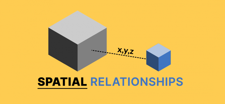
The term “spatial relationships” refers to the way objects are arranged in relation to one another in geographic space.
For example, we can describe them as adjacency, contiguity, overlap, and proximity.
When we run a tool like spatial join, we essentially use their spatial relationship with other features in geographic space.
It’s no different for topological relationships. But in this case, we are understanding error based on its spatial relationship as well.


please send me articles on conjunction of brain
I am working for children with special needs. This article has helped me to generalize how spatial knowledge helps children to solve problems in writing.