Viewshed Analysis in GIS
DEFINITION:
Viewshed Analysis is a technique that finds which areas on a map are visible from a specific point or set of points, based on the terrain’s elevation.
What Is a Viewshed Analysis?
Viewshed analysis is a 3D geospatial technique that enables us to assess what is visible from a specific vantage point.
By analyzing potential obstructions, viewsheds allow us to identify areas that are visible or hidden from a given location.
In GIS, viewshed analysis plays a pivotal role in a wide array of applications. This ranges from urban planning and environmental conservation to telecommunications and archaeology.
This introductory article explores the concept of viewshed analysis in GIS. We try to shed light on its significance and practical applications
10 Applications of Viewshed Analysis
Viewshed analysis in GIS has a wide range of practical applications across various fields. Here are some of its key applications:
1. Urban Planning
Viewshed analysis helps urban planners identify scenic viewpoints. They can also assess the visual impact of new developments, and plan public spaces to preserve views of landmarks or natural features.
2. Environmental Conservation
Conservationists use viewsheds to evaluate the impact of infrastructure projects on the landscape. This ensures the protection of scenic and ecologically sensitive areas.
3. Telecommunications
Telecom companies employ viewsheds to select optimal locations for communication towers and antennas. They consider visibility to provide reliable coverage.
4. Tourism and Recreation
The tourism industry uses viewshed analysis to identify picturesque viewpoints. They can also use it to design trails or attractions that showcase scenic vistas, enhancing visitor experiences.
5. Archaeology
Archaeologists use viewsheds to understand how historical sites were connected visually. This can help shed light on ancient communication networks and settlement patterns.
6. Military Strategy
The military employs viewsheds to assess strategic positions. They can identify areas with advantageous visibility and understand potential blind spots.
7. Real Estate
Viewsheds are valuable for property development. It allows real estate professionals to market properties with desirable views and assess the impact of new constructions.
8. Renewable Energy
When siting wind farms, viewshed analysis helps determine areas where these structures are visible. It can also help address concerns and minimize visual impacts.
9. Emergency Response
Viewsheds aid emergency planners in identifying optimal locations for observation points, communication towers, or command centers to ensure clear visibility.
10. Visual Impact Assessment
In landscape architecture and engineering, viewshed analysis assists in assessing the visual impact of infrastructure projects on the surrounding environment.
These applications show how viewshed analysis contributes to effective decision-making. From spatial planning to resource management, we can use it across diverse industries.
READ MORE: Viewshed Analysis vs Line of Sight
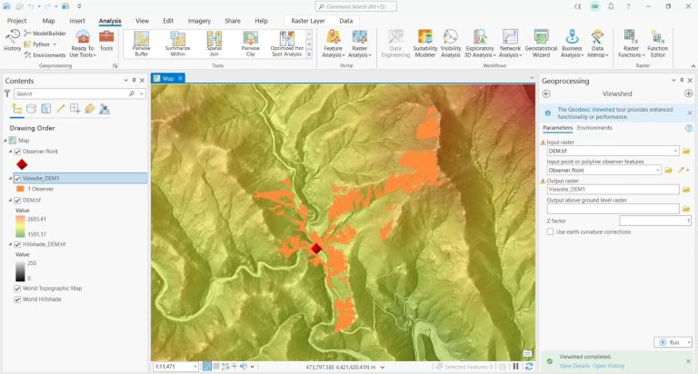
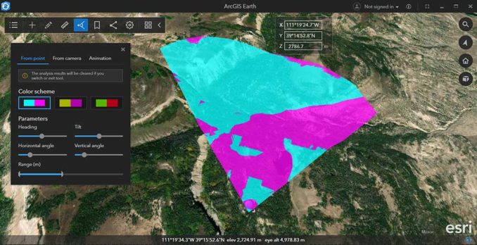
Viewshed Analysis in GIS
A viewshed illustrates the observable areas from a given observer’s standpoint. Unlike using a linear input like the line of sight analysis, viewshed analysis uses a single point as its input.
Similar to the line of sight, the goal is to understand visibility from the observer’s perspective. However, the output takes the form of a raster, indicating visibility.
Do you have any questions?
We’d love to hear from you. Please let us know any questions you may have in the comments section below.


