What is an Aspect Map?
DEFINITION:
An aspect map shows the direction a slope faces, telling you whether the slope faces north, south, east, west, or any direction in between.
How do slope and aspect relate?
When the terrain is flat, there is no slope… So this also means that there is no aspect.
But in the mountains, there are slopes in all directions. There are north-facing, west-facing, south-facing, and east-facing slopes. The compass direction that the slope faces is aspect.
…And there are some unique real-world applications of aspect maps:
Let’s look into this a bit deeper. How do you measure the aspect? And how can we use aspect data for analysis?
Understanding an aspect map
The concept of an aspect map is simple to understand. Aspect values indicate the directions the physical slopes face. We can classify aspect directions based on the slope angle with a descriptive direction. An output aspect raster will typically result in several slope direction classes.
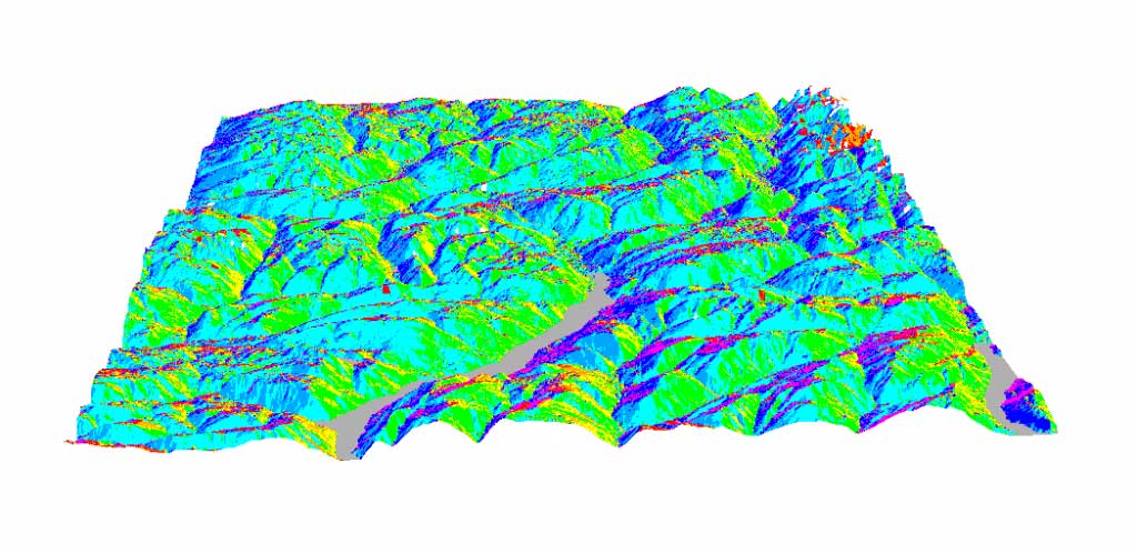
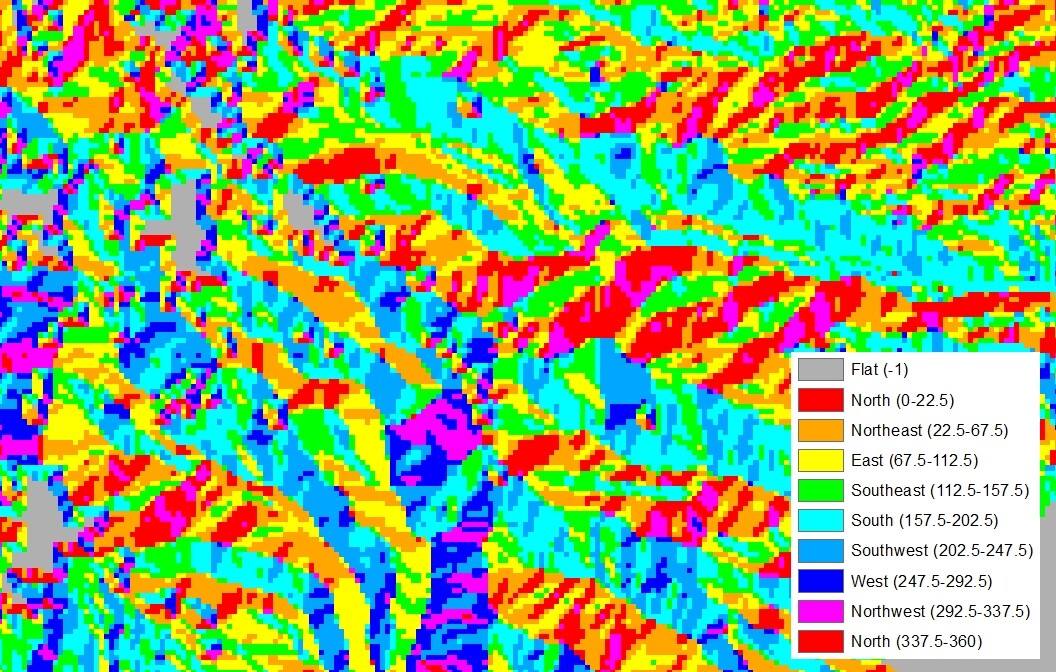
Here is an example of an aspect map from the south point of view:
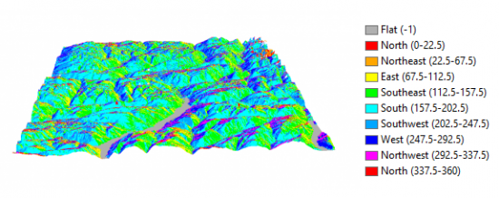
If no slope exists, then the cell value will be -1. These are the grey cells in the aspect map above. Where slope exists, aspect is measured clockwise starting north at 0°. It returns back as 360° north again.
Here is how the Aspect tool classifies an aspect map:
- Flat (-1)
- North (0°to 22.5°)
- Northeast (22.5° to 67.5°)
- East (67.5° to 112.5°)
- Southeast (112.5° to 157.5°)
- South (157.5° to 202.5°)
- Southwest (202.5° to 247.5°)
- West (247.5° to 292.5°)
- Northwest (292.5° to 337.5°)
- North (337.5° to 360°)
The aspect map above is from a south point of view. That’s why the shades on the map are mostly light green (southeast), light blue (south), and blue (southwest).
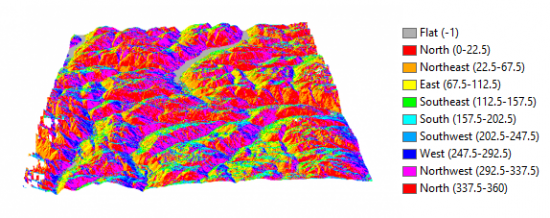
When you rotate the map as a north point-of-view, you see mostly purple (northwest), red (north), and orange (north-east):
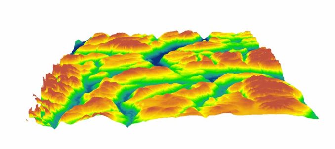
How to create an aspect map
You will need a Digital Elevation Model (DEM) to generate an aspect map. Here’s a list of free global DEM data sources or free LiDAR data sources to help you get started.
You only need one input to create an aspect map. That one input is your DEM:
After running the Aspect tool, the output raster symbolizes based on the direction slope. Each slope direction will represent a slope angle range.
You can reclassify the aspect map by changing the symbology and setting the number of classes.
For example, if you only want to display north, east, south, west, and flat classes in the color ramp, you can reduce the classes to 5. From here you can set breaks at -1, 45°, 90°, 135°, and 180°.
Uses and applications of slope aspect maps
The direction a slope faces with respect to the sun (aspect) has a profound influence on vegetation, snowpack, and construction. On top of that, exposure to the wind is being researched as two aspect applications:

MICROCLIMATE: When you expose slopes to sunlight, it creates microclimate conditions. In other words, these are mini-climate areas different from the area around them. For example, there can be a south-facing hill that supports small woody plant species because it is much hotter, dryer, and more desert-adapted.
SPECIALIZED AGRICULTURE: Cultivating south-facing slopes in the Swiss Alps using aspect data because it shelters from cold and dry winds which is critical to successful crop growth. Farmers also herd cattle and sheep in the Swiss Alps and move them away from the snow-covered peaks to the valley floor.
SKI SLOPE SELECTION: Aspect maps are ideal in ski slope site selection because the slope direction determines how much incoming solar radiation directly hits the face of the slope affecting the overall quality of ski slopes. For this reason, planners prefer north, northwest, and northeast slopes for ski slopes.
BUILDING CONSTRAINTS: Prohibiting construction on south-facing slopes because they undergo more extensive freeze/thaw cycles. This freeze/thaw cycle can erode the ground beneath and reduce the overall stability. Aspect data can determine these prohibited building zones.
REMNANTS RAINFOREST: Remnants of rainforest (in Australia) are almost always found on east-facing slopes because they protect from the westerly wind. Also, lower radiation loads result in reduced water loss. This protects rainforests from fires and helps these species survive in these microclimates.
VEGETATION EROSION: Finding the dominant vegetation types dependent on aspect and enhancing erosion modeling using aspect and vegetation to see how slopes will erode over time along with precipitation, temperature, and growing periods. Also, land degradation by interpreting soil erosion and surface runoff has been extensively modeled using its aspect.
Now, you try
The compass direction that the slope faces is your slope aspect.
You’ve learned some unique real-world applications of using the Aspect tool such as mountain agriculture, building constraints, and microclimate vegetation.
Also, you don’t have to express aspect maps only with elevation values. For example, you can represent pH and soil moisture in aspect maps.
Where have you used the Aspect tool? Let me know with a comment below.


I just stumbled upon this, really informative, but I think the breaks in the Section “How to create an aspect map” should be -1,45, 135,225,315. But other than that thanks for this nice piece of information!
Thanks for this. I really appreciate this article
Another application: The wind today is from the NE, where can I fly my paraglider and get ridge lift? I need to know both aspect, slope, and distance.
Another question is this, how does south-facing slopes undergo more extensive freeze/thaw cycles.
That was a wonderful explanation of an aspect map. My question is this: apart from west-facing slope which other slope facing direction have high amounts of sun radiation
Hi after executing my aspect map I don’t have any colours on it, everything is grey. How can I do it to have the colour ramp you said ?
You can add the image from this post (non-georeferenced), then use the color picker to find the RGB value. Next, change the aspect map accordingly.
Hi, I am using the MODIS snow product, I have created an aspect map and slope map so now I need to study the snow cover area for different eight aspects and in different slopes could you give me some hints how to do it using Arc map?
Hey guys, what a great article, helped me a lot, but I still have one doubt, that I believe is extremely simple for you to answer me, given your vast knowledge. How can I display my aspect map in 3D in ArcScene?