5 Live Satellite Maps to See Earth in Real-Time
Live Satellite Maps to See Earth in Real-Time
Ever since Apollo 17 captured the famous Blue Marble photograph of Earth in 1972, we have had a good idea of what our planet looks like.
But have you ever wondered what Earth looks like right NOW?
This article aims to show you how to view a live satellite map of the world.
From near real-time satellite views to live feeds, make sure to stay tuned and give them all a try.
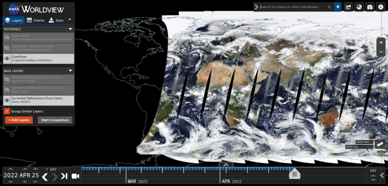
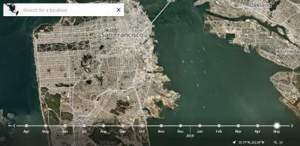
1. NASA Worldview
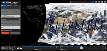
NASA’s Worldview is a real-time satellite map that is available online. It shows satellite imagery, real-time cloud cover, and 800+ layers of the world.
It uses Corrected Reflectance (True Color) from Terra/MODIS that refreshes daily. But the platform is able to publish images generally within 60 to 125 minutes after a satellite observation.
Using its slick interface, you can zoom in and out of different areas. But the resolution of the imagery is 250 meters per pixel so you can’t see too much detail.
2. USGS EarthNow (FarEarth Observer)
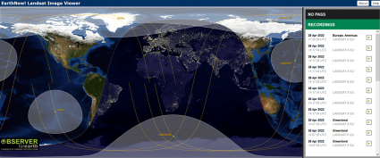
The USGS pulls together Landsat 7 and 8 recordings through the EarthNow application. After a ground station receives a Landsat transmission, it takes just seconds for it to be uploaded on the USGS EarthNow platform.
You have the option of choosing to view the image in true color, which is similar to how our human eyes see the world. Otherwise, you can also select the vegetation analysis band combination to highlight chlorophyll fluorescence.
One of the best things about the application is how it scans the Earth similar to a live stream video. And don’t forget that if you want to download Landsat imagery, check out this guide that we are linking to.
3. ISS Satellite Feed

It’s true that the International Space Station has a high-definition streaming video (HDEV) mounted on it. And if you haven’t seen it before, it’s one of the neatest things you can find on YouTube.
Although you don’t get georeferenced information that you would on a map, the ISS satellite feed provides a real-time planetary perspective from 248 miles (400 kilometers) above Earth.
And it’s seen its fair share of excitement. From the dancing Aurora Borealis over the Arctic to thunderclouds and lightning bolts, some things just look better from space.
4. Real-time Weather App
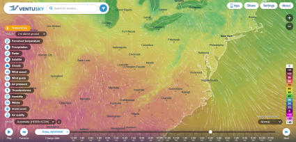
Weather apps like Ventusky leverage satellite layers from GOES-16, GOES-17, and EUMETSAT. Not only do you get near-real-time weather data, but it also includes forecasts.
This stylish mapping platform includes wind, rain, and temperature in an animated map. Plus, it incorporates data from forecast models to predict weather outcomes around the world.
If you’re looking for an alternative to Ventusky, don’t forget to check Earth Null School which has similar capabilities. Supercomputers power Earth Null School weather forecasts with updates every 3 hours.
5. Planetscope
First, PlanetScope isn’t free. But it’s the sharpest picture of Earth that we can achieve every day. This is why its motto is: “The Entire Earth, Everyday”.
Thanks to the lightweight and low-cost constellation of 200+ nanosatellites or CubeSats, each and every small payload brings big opportunities to the world of satellite imaging.
Planet is able to put it all together into its cloud-based imagery platform, PlanetScope. As such, it delivers images of Earth at 3 meters per pixel every day, which is uncontested in satellite imagery.
Live Satellite Maps
Although there are several options for a live satellite map of the world, each one has its advantages and disadvantages.
If you’re looking for a live feed, the ISS feed is the perfect option.
But if you want the latest georeferenced imagery, then NASA’s Worldview and USGS EarthNow are perfect for you.
Otherwise, the sharpest and near real-time satellite view would be Planetscope at 3 meters per pixel and a new image of Earth every day.


I want to see my house
can I see my house
It seems like none of these maps are live. They show vehicles in my driveway that haven’t been for over a year.
The more high-resolution maps are near real-time
that’s what I have noticed, too… I wanted to see if there is a way I could see even near real time images of a place I had to leave my car overnight to see that it has not been broken into or vandalized or worse… don’t think that is an option tho either :/
The imagery is not that good yet in real-time. The best it gets are the cube satellites from Planet. Unfortunately, it has a cost though
How do I apply and pay for the best satellite application to watch the progress of our new house being constructed in La Paz, MEXICO?
I would suggest using Planet (PlanetLabs)
are you aware of the requirements to be registered for the users of my property? Anyone that utilizes any portion of my property is expected to be a registered user. effective 1994-present. No the usage is not free.
I would like to see my house right now as I am out of the country and a hurricane just went through.
i want to see my neighborhood find out where jerk is thats lighting off fireworks and m80’s 12:30am! supposedly 13 fires in antioch, CA~
l want to see my house live
Is it true?
No.
I want to see a house that I want to buy
I would like to watch my region in a real time for Deforestation and Mining issue to conserve. Which one is the best for real time watching please
I recommend checking out the Global Forest Watch website, which specializes in deforestation monitoring – https://www.globalforestwatch.org/map/
which site is like Google earth, but gives more current pics?? like updates every month or 2 months?
The best one is actually a PlanetLabs which is a paid website. Their constellation uses nano satellites and basically gives you a fresh picture of Earth daily.
What is best to use, to see real time street movement
So movement is something different. The only thing I can think of is SkySat. It’s capable of capturing video footage at sub-meter resolution.
See #29 from our satellite list – https://gisgeography.com/earth-satellite-list/
I think that this is much better suited for security cameras.
I really hope this is a joke!! no planes release massive amount of mist that would in any way do anything you are describing.
Eric says:
Which satellite website would show planes that are releasing massive amounts of mist that covers the whole town and heats up our temperature
Actually Greg, they truly do. Take some time to do some EXTENSIVE research through a search engine other than the big names (Google, Bing, etc.) and I guarantee you’ll be surprised at what you may find out.
They actually do. Massachusetts just passed a law outlawing spraying to block the sun. Ever see contrails that don’t go away but expand within hours to look like clouds? Its calcium carbonate. That makes up most of what is sprayed but there is a small amount that is not revealed. A small percentage but its kept secret.
Weather modification has been completely normalized in the west. We see it all the time. I’m happy to hear MA is not allowing it. Sadly our sky’s are full of chemicals (silver iodide) to increase rain.
Chem trails. There are Solar Geo Engineering projects/programs(Harvard)… They spray atomized aluminum and barium in order to reflect the Sun from the Earth and prevent global warming or slow it down anyway. There is a woman from the Air Force, who used to authorize the chemicals that gets sprayed in the sky. when she realized that chemtrails were real and that she was the one approving the chemicals to be sprayed, she decided to turn against it and become a whistleblower. I believe she’s suing right now actually and should be able to be searched for online..
Which satellite website would show planes that are releasing massive amounts of mist that covers the whole town and heats up our temperature
You mean huge amounts of any kind of chemtrails being sprayed daily all over the world ( and especially across of my country sky which is Italy )… Governments are involved in this evil project but they would never say the truth about it.
Who wants to watch their house? ….when you can watch wildlife and thunderstorms. When a thunderstorm is going on right now? That’s what I don’t understand.
how do I see location of current wildfire in NC
It’s possible for (near) real-time wildfires with these maps… But here are a couple of other suggestions:
If you’re looking for a simple point location of where there are wildfires in North Carolina, you can try out #2 (Worldview/FIRMS) on our list of wildfire maps – https://gisgeography.com/wildfire-maps-real-time/
The last option I’d like to recommend is Sentinel Playground (now the Copernicus Browser). I tested it out… it’s a bit slow at time. All you have to do is click the green arrow to the see the latest date of imagery. You have to zoom into your area of interest and you’ll be able to see the latest available satellite imagery for that area. It seems have a one day lag time. But imagery is 10m resolution, which is pretty good for free – https://dataspace.copernicus.eu/browser/
The Earth is such a beautiful thing to humans
Thank you for this article. It came up in a search for exactly this info and here you have put it into one easy to find place.
Thank you also for the excellent links to more GIS info. Peace.
Can I use my GPS tools to see satellite image of my house? Thanks.
What satellite system will help you watch your house in real-time?
I’m pretty sure you could probably find something but not without paying a heap of money and it’s probably a good thing because real time satalite might be used for purposes of nefarious nature, if you need to watch your own house, get security cameras and a drone, not saying this is about you, but I don’t think the public (or government etc ) can be trusted with real time satalite,
Just saying
I want to see the forest fire near my town
Take a look at our article on real-time wildfire maps – https://gisgeography.com/wildfire-maps-real-time/
Can I see the most beautiful places in Dubai?
I need to see my province Manus Island
I need to watch your house 🤣
when I first started using Google Earth a long time ago, you were able to choose whether you wanted to have borders such as between states and provinces Etc and street names as you gradually zoomed down close to the area you wanted the street names would pop up that was so helpful. I don’t know if I’m missing something or not can somebody tell me if it’s still possible to get street names?
I always want to see wildlife and family live! that’s not really stalking is it?
I don’t understand all these peeps who want to be able to view their house in real time.. invest in a security camera system!
I already know what my house looks like! There are endless places on our Earth that are more exciting to look at!!
A wife you can trust? 🤣🤣🤣🤣 With this legal system?
RIGHT!!
“…we don’t have a divine right to expect people to give us the results of their work for nothing. You’ve been loading ‘free’ apps for too long. Nothing is entirely free forever.”
The US space-program was funded by the US taxpayer, and much of the technology was later ‘transterred’ to private corporate interests – who is really gaining from the work of others? The entire industry owes its existence to the unending generosity of the US taxpayer, as do many so-called ‘private’ corporate enterprises.
Everybody stop watching each other’s houses and watch your wallets and go do some work.
Need to watch your house? Get a wife you can trust or buy a security system. Even if you could watch live view like the Government can. There are still rules such as privacy. you guys sound more like stalkers or control freaks
Can I see del Rosario oas live?
To the person who wrote “Useless. Google Maps/Earth gives me a far better view than these websites.” – you DO realize that Google maps most detailed images are taken from low-flying aircraft, not satellites. That’s why they are less detailed in ‘inaccessible’ parts of the world like North Korea, and also why they are usually years old
.
To the person who complained that 7 years ago there were more and free…. we don’t have a divine right to expect people to give us the results of their work for nothing. You’ve been loading ‘free’ apps for too long. Nothing is entirely free forever.
That’s the best we have?
7 yrs ago there were better sites…and they were free!
Useless. Google Maps/Earth gives me a far better view than these websites.
I need to watch your house too!
I need to watch my house
I need to watch my house